List of bridges on the National Register of Historic Places in Missouri
This is a list of bridges and tunnels on the National Register of Historic Places in the U.S. state of Missouri.[1]
| Name | Image | Built | Listed | Location | County | Type | |
|---|---|---|---|---|---|---|---|
| Arrow Rock State Historic Site Bridge | ca. 1937 | 1985-03-04 | Arrow Rock 39°4′6″N 92°56′39″W / 39.06833°N 92.94417°W / 39.06833; -92.94417 (Arrow Rock State Historic Site Bridge) | Saline | |||
| Barretts Tunnels |  | 1851, 1853 | 1978-12-08 | Kirkwood 38°34′21″N 90°27′18″W / 38.57250°N 90.45500°W / 38.57250; -90.45500 (Barretts Tunnels) | St. Louis | ||
| Boeckman Bridge | 1926 | 1979-03-19 | St. Elizabeth 38°13′35″N 92°14′23″W / 38.22639°N 92.23972°W / 38.22639; -92.23972 (Boeckman Bridge) | Miller | |||
| Brownville Bridge |  | 1939 | 1993-06-17 | Phelps City 40°23′57″N 95°39′6″W / 40.39917°N 95.65167°W / 40.39917; -95.65167 (Brownville Bridge) | Atchison | ||
| Burfordville Covered Bridge | 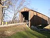 | 1858 | 1970-05-19 | Burfordville 37°22′2″N 89°48′9″W / 37.36722°N 89.80250°W / 37.36722; -89.80250 (Burfordville Covered Bridge) | Cape Girardeau | Howe truss | |
| Chain of Rocks Bridge |  | 1929, 1936 | 2006-12-01 | St. Louis | St. Louis City | Warrant Truss | |
| Crowder State Park Vehicle Bridge | ca. 1939 | 1985-03-04 | Trenton 40°5′31″N 93°39′51″W / 40.09194°N 93.66417°W / 40.09194; -93.66417 (Crowder State Park Vehicle Bridge) | Grundy | Rustic arch | ||
| Eads Bridge |  | 1867, 1874 | 1966-10-15 | St. Louis 38°37′45″N 90°11′8″W / 38.62917°N 90.18556°W / 38.62917; -90.18556 (Eads Bridge) | St. Louis City | Cantilever deck arch | |
| Grand Auglaize Bridge | 1931-31 | 2020-10-08 | vic. of Brumley | Miller | A suspension and swinging bridge designed and built by Dice. | ||
| Hargrove Pivot Bridge | 1917 | 1985-10-15 | Poplar Bluff 36°38′50″N 90°18′0″W / 36.64722°N 90.30000°W / 36.64722; -90.30000 (Hargrove Pivot Bridge) | Butler | Wichert and Warren Truss | ||
| Jefferson Street Footbridge |  | 2003-09-02 | Springfield 37°13′58″N 93°17′21″W / 37.23278°N 93.28917°W / 37.23278; -93.28917 (Jefferson Street Footbridge) | Greene | Cantilever Through Truss | ||
| Locust Creek Covered Bridge | 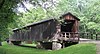 | 1868 | 1970-05-19 | Laclede 39°47′30″N 93°14′3″W / 39.79167°N 93.23417°W / 39.79167; -93.23417 (Locust Creek Covered Bridge) | Linn | ||
| Meramec River U.S. 66 Bridge - J421 | 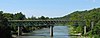 | 2009-9-16 | Eureka38°30′20″N 90°35′31.19″W / 38.50556°N 90.5919972°W / 38.50556; -90.5919972 (Meramec River U.S. Bridge - J421) | St. Louis | Warren deck truss | ||
| Montserrat Recreation Demonstration Area Bridge | 1937 | 1985-03-04 | Knob Noster 38°45′13″N 93°34′36″W / 38.75361°N 93.57667°W / 38.75361; -93.57667 (Montserrat Recreation Demonstration Area Bridge) | Johnson | |||
| Papinville Marais des Cygnes River Bridge | 1884 | 2002-10-22 | Papinville 38°4′6″N 94°13′54″W / 38.06833°N 94.23167°W / 38.06833; -94.23167 (Papinville Marais des Cygnes River Bridge) | Bates | Pinned Pratt through truss | ||
| Pin Oak Hollow Bridge | 1934, 1938 | 1985-09-13 | Pin Oak Hollow 38°6′50″N 92°36′43″W / 38.11389°N 92.61194°W / 38.11389; -92.61194 (Pin Oak Hollow Bridge) | Camden | Single-arch | ||
| Powell Bridge |  | 1915 | 2011-4-20 | Powell vicinity 36°36′57″N 94°10′56″W / 36.61583°N 94.18222°W / 36.61583; -94.18222 (Powell Bridge) | McDonald | Pinned Pratt through truss | |
| Rulo Bridge |  | 1938, 1939 | 1993-01-04 | Fortescue 40°3′14″N 95°25′14″W / 40.05389°N 95.42056°W / 40.05389; -95.42056 (Rulo Bridge) | Holt | Pennsylvania through truss | |
| Sandy Creek Covered Bridge | 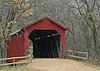 | 1872 | 1970-07-08 | Hillsboro 38°17′38″N 90°31′5″W / 38.29389°N 90.51806°W / 38.29389; -90.51806 (Sandy Creek Covered Bridge) | Jefferson | Howe Truss | |
| Swan Creek Bridge | 1914, 1932 | 1983-09-08 | Forsyth 36°42′2″N 93°5′8″W / 36.70056°N 93.08556°W / 36.70056; -93.08556 (Swan Creek Bridge) | Taney | |||
| Union Covered Bridge | 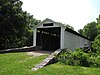 | 1870, 1871 | 1970-06-15 | Paris 39°25′58″N 92°6′9″W / 39.43278°N 92.10250°W / 39.43278; -92.10250 (Union Covered Bridge) | Monroe | ||
| Upper Bridge | 1928 | 1999-09-17 | Warsaw 38°14′39″N 93°23′16″W / 38.24417°N 93.38778°W / 38.24417; -93.38778 (Upper Bridge) | Benton | |||
| Waddell "A" Truss Bridge | 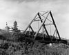 | 1898, 1980, 1987 | 1991-01-25 | Parkville 39°11′9″N 94°40′55″W / 39.18583°N 94.68194°W / 39.18583; -94.68194 (Waddell "A" Truss Bridge) | Platte | Waddell "A" truss | |
| Waverly Bridge | |||||||
| Windsor Harbor Road Bridge | 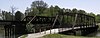 | 1874, 1875 | 1983-09-08 | Kimmswick 38°21′50″N 90°21′44″W / 38.36389°N 90.36222°W / 38.36389; -90.36222 (Windsor Harbor Road Bridge) | Jefferson | ||
| Y Bridge |  | 1926, 1927 | 1991-05-23 | Galena 36°48′18″N 93°27′41″W / 36.80500°N 93.46139°W / 36.80500; -93.46139 (Y Bridge) | Stone | Open spandrel arch Y bridge |
References
Map all coordinates using OpenStreetMap
Download coordinates as:
- KML
- GPX (all coordinates)
- GPX (primary coordinates)
- GPX (secondary coordinates)
- ^ "National Register Information System". National Register of Historic Places. National Park Service. July 9, 2010.
- v
- t
- e
- Alabama
- Alaska
- Arizona
- Arkansas
- California
- Colorado
- Connecticut
- Delaware
- Florida
- Georgia
- Guam
- Hawaii
- Idaho
- Illinois
- Indiana
- Iowa
- Kansas
- Kentucky
- Louisiana
- Maine
- Maryland
- Massachusetts
- Michigan
- Minnesota
- Mississippi
- Missouri
- Montana
- Nebraska
- Nevada
- New Hampshire
- New Jersey
- New Mexico
- New York
- North Carolina
- North Dakota
- Ohio
- Oklahoma
- Oregon
- Pennsylvania
- Puerto Rico
- Rhode Island
- South Carolina
- South Dakota
- Tennessee
- Texas
- Utah
- Vermont
- Virginia
- Washington
- Washington, D.C.
- West Virginia
- Wisconsin
- Wyoming


