List of bridges on the National Register of Historic Places in Alabama
This is a list of bridges and tunnels on the National Register of Historic Places in the U.S. state of Alabama.[1]
| Name | Image | Built | Listed | Location | County | Type |
|---|---|---|---|---|---|---|
| Clarkson–Legg Covered Bridge |  | 1904 | 1974-06-25 | Cullman 34°12′27″N 86°59′28″W / 34.20750°N 86.99111°W / 34.20750; -86.99111 (Clarkson Bridge) | Cullman | Two-span Town truss |
| Coldwater Covered Bridge |  | ca. 1845 | 1973-04-11 | Coldwater 33°35′10″N 85°54′47″W / 33.58611°N 85.91306°W / 33.58611; -85.91306 (Coldwater Creek Covered Bridge) | Calhoun | Covered kingpost truss |
| Easley Covered Bridge |  | ca. 1927 | 1981-08-20 | Oneonta 33°58′15″N 86°31′6″W / 33.97083°N 86.51833°W / 33.97083; -86.51833 (Easley Covered Bridge) | Blount | Covered Town truss |
| Five Mile Creek Bridge | ca. 1911 | 1973-02-28 | McCalla 33°21′7″N 87°1′19″W / 33.35194°N 87.02194°W / 33.35194; -87.02194 (Five Mile Creek Bridge) | Jefferson | ||
| Half Chance Iron Bridge |  | ca. 1880 | 1972-09-14 | Dayton 32°18′39″N 87°41′59″W / 32.31083°N 87.69972°W / 32.31083; -87.69972 (Half-Chance Bridge) | Marengo | Bowstring truss |
| Horton Mill Covered Bridge | 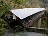 | 1934, 1935 | 1970-12-29 | Oneonta 34°0′58″N 86°26′55″W / 34.01611°N 86.44861°W / 34.01611; -86.44861 (Horton Mill Covered Bridge) | Blount | Covered Town truss |
| Kymulga Mill & Covered Bridge |  | ca. 1860, ca. 1864 | 1976-10-29 | Childersburg 33°20′3″N 86°18′1″W / 33.33417°N 86.30028°W / 33.33417; -86.30028 (Kymulga Mill and Covered Bridge) | Talladega | Covered |
| Nectar Covered Bridge |  | 1934 | 1981-08-20 | Nectar 33°57′22″N 86°37′34″W / 33.95611°N 86.62611°W / 33.95611; -86.62611 (Nectar Covered Bridge) | Blount | Covered Town truss |
| Oakachoy Covered Bridge | 1915 | removed 2001-09-23 | Nixburg | Coosa | Covered queen post truss | |
| Edmund Pettus Bridge |  | 1940 | 2013-03-11 | Selma 32°24′20″N 87°01′07″W / 32.4056°N 87.0186°W / 32.4056; -87.0186 (Edmund Pettus Bridge) | Dallas | Steel through arch bridge |
| Swann Covered Bridge | 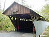 | 1933 | 1981-08-20 | Cleveland 33°59′50″N 86°36′6″W / 33.99722°N 86.60167°W / 33.99722; -86.60167 (Swann Covered Bridge) | Blount | Covered Town truss |
See also
References
Map all coordinates using OpenStreetMap
Download coordinates as:
- KML
- GPX (all coordinates)
- GPX (primary coordinates)
- GPX (secondary coordinates)
- ^ "National Register Information System". National Register of Historic Places. National Park Service. July 9, 2010.
- v
- t
- e
- Alabama
- Alaska
- Arizona
- Arkansas
- California
- Colorado
- Connecticut
- Delaware
- Florida
- Georgia
- Guam
- Hawaii
- Idaho
- Illinois
- Indiana
- Iowa
- Kansas
- Kentucky
- Louisiana
- Maine
- Maryland
- Massachusetts
- Michigan
- Minnesota
- Mississippi
- Missouri
- Montana
- Nebraska
- Nevada
- New Hampshire
- New Jersey
- New Mexico
- New York
- North Carolina
- North Dakota
- Ohio
- Oklahoma
- Oregon
- Pennsylvania
- Puerto Rico
- Rhode Island
- South Carolina
- South Dakota
- Tennessee
- Texas
- Utah
- Vermont
- Virginia
- Washington
- Washington, D.C.
- West Virginia
- Wisconsin
- Wyoming


