List of lighthouses in Cape Verde
The following article is a list of lighthouses in Cape Verde.[1][2] Cape Verde has tens of lighthouses scattered across its nine major islands. The lighthouses are administered by the Direction of Marine and Ports (Direcção Geral de Marinha e Portos) or DGMP.[3]
Map all coordinates using OpenStreetMap
Download coordinates as:
- KML
- GPX (all coordinates)
- GPX (primary coordinates)
- GPX (secondary coordinates)
Boa Vista
| Name | Image | Year built | Location & coordinates | Class of Light[2] | Focal height (metres)[2] | NGA number[2] | Admiralty number[2] | Range (nautical miles)[2] |
|---|---|---|---|---|---|---|---|---|
| Morro Negro Lighthouse | 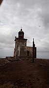 | 1930 | Morre Negro 16°6′0″N 22°41′0″W | Fl W 20s | 163 | 113-24196 | D2914 | 31 |
| Ponta da Escuma Lighthouse | 1888 | Ilhéu de Sal-Rei 16°10′21″N 22°55′55″W | Fl(5) WR 20s | 28 | 113-24192 | D2918 | 11 | |
| Ponta Varandinha Lighthouse | Image | Ponta Varandinha 16°2′31″N 22°57′56″W | Fl(2) W 6s | 22 | 113-24197 | D2916 | 10 |
Brava
| Name | Image | Year built | Location & coordinates | Class of Light[2] | Focal height (metres)[2] | NGA number[2] | Admiralty number[2] | Range (nautical miles)[2] |
|---|---|---|---|---|---|---|---|---|
| Ilhéu de Cima Lighthouse | Ilhéu de Cima 14°57′55″N 24°38′31″W | Fl(3) W 12s | 80 | 113-24260 | D2904 | 9 | ||
| Ponta Nhô Martinho Lighthouse | Ponta Nho Martinho 14°48′12″N 24°42′6″W | Fl(4) W 15s | 29 | 113-24240 | D2910 | 9 | ||
| Ponta Jalunga Lighthouse | Image | 1891 | Furna 14°53′26″N 24°40′26″W | Fl(2+1) W 15s | 26 | 113-24236 | D2908 | 5[4] |
Fogo
| Name | Image | Year built | Location & coordinates | Class of Light [2] | Focal height [2] | NGA number [2] | Admiralty number [2] | Range nml [2] |
|---|---|---|---|---|---|---|---|---|
| Ponta do Alcatraz Lighthouse | n/a | Dacabalaio 14°50′14″N 24°18′52″W / 14.837139°N 24.314333°W / 14.837139; -24.314333 | Fl W 4s. | 135 metres (443 ft) | 24256 | D2904 | 9 |
Maio
| Name | Image | Year built | Location & coordinates | Class of Light [2] | Focal height [2] | NGA number [2] | Admiralty number [2] | Range nml [2] |
|---|---|---|---|---|---|---|---|---|
| Forte de São José Lighthouse | Image | 1887 | Forte de São José 15°08′12″N 23°12′45″W / 15.136639°N 23.212472°W / 15.136639; -23.212472 | Fl (3) R 12s. | 22 metres (72 ft) | 24200 | D2872 | 9 |
| Ponta Cais Lighthouse | n/a | Ponta Cais 15°20′15″N 23°10′47″W / 15.337631°N 23.179723°W / 15.337631; -23.179723 | Fl W 7s. | 14 metres (46 ft) | 24202 | D2874 | 10 |
Sal
| Name | Image | Year built | Location & coordinates | Class of Light [2] | Focal height [2] | NGA number [2] | Admiralty number [2] | Range nml [2] |
|---|---|---|---|---|---|---|---|---|
| Pedra de Lume Lighthouse |  | n/a | Pedra de Lume 16°45′50″N 22°53′34″W / 16.763917°N 22.892833°W / 16.763917; -22.892833 | F R (occasional) | 13 metres (43 ft) | 24180 | D2923.1 | 1 |
| Ponta do Norte Lighthouse | ~1940 | Ponta do Norte 16°51′05″N 22°54′54″W / 16.851444°N 22.915083°W / 16.851444; -22.915083 | Fl (3) W 12s. | 16 metres (52 ft) | 24147 | D2919.75 | 8 | |
| Ponta do Sinó Lighthouse |  | 1892 | Santa Maria 16°35′20″N 22°55′17″W / 16.588992°N 22.921497°W / 16.588992; -22.921497 | Fl (2+1) W 15s. | 11 metres (36 ft) | 24164 | D2922 | 8 |
| Ponta de Vera Cruz Lighthouse | n/a | Santa Maria 16°35′47″N 22°54′15″W / 16.596389°N 22.904139°W / 16.596389; -22.904139 | F R | 5 metres (16 ft) | 24168 | D2922.5 | 3 |
Santiago
| Name | Image | Year built | Location & coordinates | Class of Light [2] | Focal height [2] | NGA number [2] | Admiralty number [2] | Range nml [2] |
|---|---|---|---|---|---|---|---|---|
| Dona Maria Pia Lighthouse | 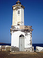 | 1881 | Ponta Temerosa 14°54′02″N 23°30′33″W / 14.900417°N 23.509056°W / 14.900417; -23.509056 | Fl (2) W 6s. | 25 metres (82 ft) | 24204 | D2876 | 15 |
| Ponta do Lobo Lighthouse | Image | 1887 | Ponta do Lobo 14°59′14″N 23°25′49″W / 14.987111°N 23.430306°W / 14.987111; -23.430306 | Fl (4) W 15s. | 17 metres (56 ft) | 24210 | D2882 | 6 |
| Ponta Moreia Lighthouse | Image | n/a | Municipality of Tarrafal 15°20′18″N 23°44′34″W / 15.338472°N 23.742667°W / 15.338472; -23.742667 | Fl (5) W 20s. | 97 metres (318 ft) | 24214 | D2888 | 10 |
| Ponta Preta Lighthouse |  | 1889 est. | Tarrafal 15°17′34″N 23°46′16″W / 15.292889°N 23.771222°W / 15.292889; -23.771222 | Fl (3) W 12s. | 34 metres (112 ft) | 24215 | D2890 | 8 |
Santo Antão
| Name | Image | Year built | Location & coordinates | Class of Light [2] | Focal height [2] | NGA number [2] | Admiralty number [2] | Range nml [2] |
|---|---|---|---|---|---|---|---|---|
| Ponta de Mangrade Lighthouse | n/a | Ponta de Mangrade 17°03′14″N 25°21′26″W / 17.054°N 25.357167°W / 17.054; -25.357167 | Fl (2) W 10s. | 112 metres (367 ft) | 24092 | D2954 | 13 | |
| Ponta do Sol Lighthouse | Image Archived 2016-10-29 at the Wayback Machine | n/a | Ponta do Sol 17°12′15″N 25°05′23″W / 17.204139°N 25.089611°W / 17.204139; -25.089611 | Fl W 4s. | 15 metres (49 ft) | 24088 | D2952 | 9 |
| Ponta de Tumbo Lighthouse |  | 1886 | Janela 17°06′52″N 24°58′13″W / 17.114364°N 24.970214°W / 17.114364; -24.970214 | Fl (4) 20s. | 162 metres (531 ft) | 24080 | D2950 | 17 |
São Nicolau
| Name | Image | Year built | Location & coordinates | Class of Light [2] | Focal height [2] | NGA number [2] | Admiralty number [2] | Range nml [2] |
|---|---|---|---|---|---|---|---|---|
| Ponta do Barril Lighthouse | Image | 1891 | Ponta do Barril 16°36′19″N 24°25′07″W / 16.605222°N 24.418528°W / 16.605222; -24.418528 | Fl (3) W 12s. | 13 metres (43 ft) | 24132 | D2934 | 15 |
| Ponta Leste Lighthouse | n/a | Ponta Leste 16°34′09″N 24°00′37″W / 16.569139°N 24.010333°W / 16.569139; -24.010333 | Fl (4) 10s. | 73 metres (240 ft) | 24144 | D2930 | 11 | |
| Pregujça Lighthouse | n/a | Preguiça 16°33′42″N 24°17′06″W / 16.561683°N 24.285030°W / 16.561683; -24.285030 | Fl (2+1) R 15s. | 25 metres (82 ft) | 24136 | D2936 | 5 |
São Vicente
| Name | Image | Year built | Location & coordinates | Class of Light [2] | Focal height [2] | NGA number [2] | Admiralty number [2] | Range nml [2] |
|---|---|---|---|---|---|---|---|---|
| Cabnave Lighthouse | n/a | Mindelo 16°54′01″N 24°59′56″W / 16.900395°N 24.998836°W / 16.900395; -24.998836 | Fl R 2s. | 8 metres (26 ft) | 24104 | D2943 | 8 | |
| Don Luís Lighthouse |  | 1882 est. | Ilhéu dos Pássaros 16°54′39″N 25°00′43″W / 16.910889°N 25.011972°W / 16.910889; -25.011972 | Fl (3) W 12s. | 86 metres (282 ft) | 24100 | D2942 | 14 |
| Dona Amélia Lighthouse | 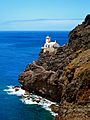 | 1894 | São Pedro 16°49′36″N 25°05′09″W / 16.826611°N 25.08575°W / 16.826611; -25.08575 | Fl W 5s. | 56 metres (184 ft) | 24096 | D2946 | 17 |
See also
References
- ^ Rowlett, Russ. "Lighthouses of Cape Verde". The Lighthouse Directory. University of North Carolina at Chapel Hill.
- ^ a b c d e f g h i j k l m n o p q r s t u v w x y z aa ab ac ad ae af ag ah ai aj ak al am an ao ap aq ar as at List of Lights, Pub. 113: The West Coasts of Europe and Africa, the Mediterranean Sea, Black Sea and Azovskoye More (Sea of Azov) (PDF). List of Lights. United States National Geospatial-Intelligence Agency. 2015.
- ^ "DGMP". Archived from the original on 2017-10-26. Retrieved 2018-02-12.
- ^ NGA List of Lights, Radio Aids and Fog Signals, National Geospatial-Intelligence Agency, Wikidata Q13872896
External links
Wikimedia Commons has media related to Lighthouses in Cape Verde.
Rowlett, Russ. "The Lighthouse Directory". University of North Carolina at Chapel Hill.
Portals:
 Africa
 Engineering
 Architecture
 Lists
Lists


- v
- t
- e
| Construction |
|
|---|---|
| Navigational purpose |

- Lighthouse builders
- Lighthouses by heritage register
- Lighthouses by century of completion
- Lighthouses by year of completion
organizations
 Category
 Commons
 Wiktionary
 WikiProject

Lists of lighthouses in Africa | ||||||
|---|---|---|---|---|---|---|
| Sovereign states |
|  | ||||


