List of listed buildings in Dunscore, Dumfries and Galloway
This is a list of listed buildings in the parish of Dunscore in Dumfries and Galloway, Scotland.
Map all coordinates using OpenStreetMap
Download coordinates as:
- KML
- GPX (all coordinates)
- GPX (primary coordinates)
- GPX (secondary coordinates)
List
| Name | Location | Date Listed | Grid Ref. [note 1] | Geo-coordinates | Notes | LB Number [note 2] | Image |
|---|---|---|---|---|---|---|---|
| Dunscore Old Churchyard (Near Farthingwell) | 55°07′55″N 3°41′06″W / 55.131867°N 3.685096°W / 55.131867; -3.685096 (Dunscore Old Churchyard (Near Farthingwell)) | Category B | 4229 |  Upload Photo | |||
| Upper Maccubbington Farmhouse | 55°08′06″N 3°43′11″W / 55.134977°N 3.71977°W / 55.134977; -3.71977 (Upper Maccubbington Farmhouse) | Category B | 4165 | Upload Photo | |||
| Dalgonar Bridge Over Cairn Water | 55°08′17″N 3°47′22″W / 55.13792°N 3.789397°W / 55.13792; -3.789397 (Dalgonar Bridge Over Cairn Water) | Category A | 4227 | Upload Photo | |||
| Dunscore Village Fairview | 55°08′26″N 3°46′41″W / 55.140611°N 3.77808°W / 55.140611; -3.77808 (Dunscore Village Fairview) | Category C(S) | 4231 | Upload Photo | |||
| Friars Carse Former Stables Including Beech Cottage | 55°08′47″N 3°41′20″W / 55.146319°N 3.688953°W / 55.146319; -3.688953 (Friars Carse Former Stables Including Beech Cottage) | Category B | 4234 | Upload Photo | |||
| Dunscore Village Dunscore Parish Church And Churchyard | 55°08′25″N 3°46′47″W / 55.140401°N 3.779592°W / 55.140401; -3.779592 (Dunscore Village Dunscore Parish Church And Churchyard) | Category A | 4230 | 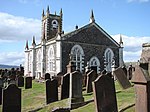 Upload another image | |||
| Lagganhill House And Steading Wing | 55°08′08″N 3°44′27″W / 55.135678°N 3.740696°W / 55.135678; -3.740696 (Lagganhill House And Steading Wing) | Category C(S) | 4236 | Upload Photo | |||
| Demperston Farmhouse | 55°08′45″N 3°46′09″W / 55.145817°N 3.769289°W / 55.145817; -3.769289 (Demperston Farmhouse) | Category C(S) | 4228 | Upload Photo | |||
| Bogrie | 55°08′41″N 3°51′56″W / 55.144802°N 3.865668°W / 55.144802; -3.865668 (Bogrie) | Category B | 4248 | Upload Photo | |||
| Stroquan Lodge, Gates And Gatepiers | 55°08′00″N 3°48′39″W / 55.133459°N 3.810909°W / 55.133459; -3.810909 (Stroquan Lodge, Gates And Gatepiers) | Category B | 4161 | Upload Photo | |||
| Throughgate Macphail Drover's Toll Tower House R J Cessford (House And Veterinary Surgery) | 55°08′22″N 3°46′03″W / 55.139362°N 3.76756°W / 55.139362; -3.76756 (Throughgate Macphail Drover's Toll Tower House R J Cessford (House And Veterinary Surgery)) | Category C(S) | 4163 | Upload Photo | |||
| Ellisland Farmhouse And Steading | 55°08′15″N 3°40′49″W / 55.137408°N 3.680215°W / 55.137408; -3.680215 (Ellisland Farmhouse And Steading) | Category A | 4232 | Upload Photo | |||
| Friars Carse Burns Hermitage | 55°08′36″N 3°41′12″W / 55.14333°N 3.686709°W / 55.14333; -3.686709 (Friars Carse Burns Hermitage) | Category B | 4233 | Upload Photo | |||
| Craigenputtock | 55°07′13″N 3°55′42″W / 55.120371°N 3.928198°W / 55.120371; -3.928198 (Craigenputtock) | Category B | 4250 | Upload Photo | |||
| Stroquan Walled Garden | 55°07′54″N 3°48′53″W / 55.131652°N 3.814591°W / 55.131652; -3.814591 (Stroquan Walled Garden) | Category C(S) | 4160 | Upload Photo | |||
| Upper Kilroy (Or High Kilroy) Farmhouse And Steading | 55°07′52″N 3°41′52″W / 55.130988°N 3.697905°W / 55.130988; -3.697905 (Upper Kilroy (Or High Kilroy) Farmhouse And Steading) | Category B | 4164 | Upload Photo | |||
| Chapel Mill Block | 55°08′32″N 3°49′58″W / 55.142131°N 3.83264°W / 55.142131; -3.83264 (Chapel Mill Block) | Category B | 4249 | Upload Photo | |||
| Stroquan House | 55°07′56″N 3°48′59″W / 55.132273°N 3.816298°W / 55.132273; -3.816298 (Stroquan House) | Category B | 4159 | Upload Photo | |||
| Sundaywell Tower Farmhouse And Steading | 55°08′23″N 3°51′58″W / 55.1398°N 3.866015°W / 55.1398; -3.866015 (Sundaywell Tower Farmhouse And Steading) | Category B | 4162 | Upload Photo | |||
| Hearse House | 55°08′25″N 3°46′37″W / 55.140242°N 3.776934°W / 55.140242; -3.776934 (Hearse House) | Category B | 6579 | Upload Photo | |||
| Glenesslin Farmhouse | 55°08′01″N 3°49′26″W / 55.13348°N 3.823977°W / 55.13348; -3.823977 (Glenesslin Farmhouse) | Category C(S) | 4235 | Upload Photo | |||
| Maccheynston Farmhouse | 55°08′26″N 3°43′04″W / 55.140659°N 3.717771°W / 55.140659; -3.717771 (Maccheynston Farmhouse) | Category B | 4237 | Upload Photo |
Key
The scheme for classifying buildings in Scotland is:
- Category A: "buildings of national or international importance, either architectural or historic; or fine, little-altered examples of some particular period, style or building type."[1]
- Category B: "buildings of regional or more than local importance; or major examples of some particular period, style or building type, which may have been altered."[1]
- Category C: "buildings of local importance; lesser examples of any period, style, or building type, as originally constructed or moderately altered; and simple traditional buildings which group well with other listed buildings."[1]
In March 2016 there were 47,288 listed buildings in Scotland. Of these, 8% were Category A, and 50% were Category B, with the remaining 42% being Category C.[2]
Notes
- ^ Sometimes known as OSGB36, the grid reference (where provided) is based on the British national grid reference system used by the Ordnance Survey.
• "Guide to National Grid". Ordnance Survey. Retrieved 12 December 2007.
• "Get-a-map". Ordnance Survey. Retrieved 17 December 2007. - ^ Historic Environment Scotland assign a unique alphanumeric identifier to each designated site in Scotland, for listed buildings this always begins with "LB", for example "LB12345".
References
- All entries, addresses and coordinates are based on data from Historic Scotland. This data falls under the Open Government Licence
- ^ a b c "What is Listing?". Historic Environment Scotland. Retrieved 29 May 2018.
- ^ Scotland's Historic Environment Audit 2016 (PDF). Historic Environment Scotland and the Built Environment Forum Scotland. pp. 15–16. Retrieved 29 May 2018.
- v
- t
- e
- Annan
- Applegarth
- Caerlaverock
- Canonbie
- Closeburn
- Cummertrees
- Dalton
- Dornock
- Dryfesdale
- Dumfries
- Dunscore
- Durisdeer
- Eskdalemuir
- Ewes
- Glencairn
- Gretna
- Half Morton
- Hoddom
- Holywood
- Hutton and Corrie
- Johnstone
- Keir
- Kirkconnel
- Kirkmahoe
- Kirkmichael
- Kirkpatrick-Fleming
- Kirkpatrick-Juxta
- Langholm
- Lochmaben
- Lockerbie
- Middlebie
- Moffat
- Morton
- Mouswald
- Penpont
- Ruthwell
- Sanquhar
- St Mungo
- Tinwald
- Torthorwald
- Tundergarth
- Tynron
- Wamphray
- Westerkirk
- Anwoth
- Balmaclellan
- Balmaghie
- Borgue
- Buittle
- Carsphairn
- Castle Douglas
- Colvend and Southwick
- Crossmichael
- Dalbeattie
- Dalry
- Gatehouse of Fleet
- Girthon
- Kells
- Kelton
- Kirkbean
- Kirkcudbright
- Kirkgunzeon
- Kirkmabreck
- Kirkpatrick Durham
- Kirkpatrick Irongray
- Lochrutton
- Minnigaff
- New Abbey
- New Galloway
- Newton Stewart
- Parton
- Rerrick
- Terregles
- Tongland
- Troqueer
- Twynholm
- Urr


