List of listed buildings in Ruthwell, Dumfries and Galloway
This is a list of listed buildings in the civil parish of Ruthwell in Dumfries and Galloway, Scotland.
Map all coordinates using OpenStreetMap
Download coordinates as:
- KML
- GPX (all coordinates)
- GPX (primary coordinates)
- GPX (secondary coordinates)
List
| Name | Location | Date Listed | Grid Ref. [note 1] | Geo-coordinates | Notes | LB Number [note 2] | Image |
|---|---|---|---|---|---|---|---|
| Clarencefield Village Whitegate And Outbuilding To North, Farmer's Inn And Mr Hair | 55°00′09″N 3°25′13″W / 55.00253°N 3.420359°W / 55.00253; -3.420359 (Clarencefield Village Whitegate And Outbuilding To North, Farmer's Inn And Mr Hair) | Category B | 17214 |  Upload Photo | |||
| Comlongon Castle And Mansion House | 55°00′24″N 3°26′27″W / 55.006566°N 3.440923°W / 55.006566; -3.440923 (Comlongon Castle And Mansion House) | Category A | 17245 | Upload Photo | |||
| Ruthwell Village Rivel Cottage And Outbuildings | 54°59′36″N 3°24′30″W / 54.993343°N 3.408201°W / 54.993343; -3.408201 (Ruthwell Village Rivel Cottage And Outbuildings) | Category B | 17248 | Upload Photo | |||
| Ruthwell Village Ruthwell Museum Henry Duncan Savings Bank And Museum | 54°59′35″N 3°24′19″W / 54.992936°N 3.405311°W / 54.992936; -3.405311 (Ruthwell Village Ruthwell Museum Henry Duncan Savings Bank And Museum) | Category A | 17249 | 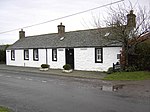 Upload another image | |||
| Brow Well | 54°59′37″N 3°25′54″W / 54.993725°N 3.43163°W / 54.993725; -3.43163 (Brow Well) | Category C(S) | 17212 | Upload Photo | |||
| Summerfield Farmhouse And Steading | 54°59′54″N 3°23′27″W / 54.998233°N 3.390863°W / 54.998233; -3.390863 (Summerfield Farmhouse And Steading) | Category C(S) | 17250 | Upload Photo | |||
| Ruthwell Parish Church And Churchyard | 55°00′01″N 3°24′27″W / 55.00028°N 3.407459°W / 55.00028; -3.407459 (Ruthwell Parish Church And Churchyard) | Category B | 17247 |  Upload another image | |||
| Aiket Farmhouse And Flanking Wings | 54°59′59″N 3°24′52″W / 54.999777°N 3.414446°W / 54.999777; -3.414446 (Aiket Farmhouse And Flanking Wings) | Category C(S) | 17210 | Upload Photo | |||
| Margaretsfield Cottages | 55°00′45″N 3°25′44″W / 55.012575°N 3.429002°W / 55.012575; -3.429002 (Margaretsfield Cottages) | Category C(S) | 17246 | Upload Photo | |||
| Clarencefield Solway View, Mr D Graham And Roadside Cottage | 55°00′10″N 3°25′14″W / 55.002842°N 3.420573°W / 55.002842; -3.420573 (Clarencefield Solway View, Mr D Graham And Roadside Cottage) | Category C(S) | 17213 | Upload Photo |
Key
The scheme for classifying buildings in Scotland is:
- Category A: "buildings of national or international importance, either architectural or historic; or fine, little-altered examples of some particular period, style or building type."[1]
- Category B: "buildings of regional or more than local importance; or major examples of some particular period, style or building type, which may have been altered."[1]
- Category C: "buildings of local importance; lesser examples of any period, style, or building type, as originally constructed or moderately altered; and simple traditional buildings which group well with other listed buildings."[1]
In March 2016 there were 47,288 listed buildings in Scotland. Of these, 8% were Category A, and 50% were Category B, with the remaining 42% being Category C.[2]
Notes
- ^ Sometimes known as OSGB36, the grid reference (where provided) is based on the British national grid reference system used by the Ordnance Survey.
• "Guide to National Grid". Ordnance Survey. Retrieved 12 December 2007.
• "Get-a-map". Ordnance Survey. Retrieved 17 December 2007. - ^ Historic Environment Scotland assign a unique alphanumeric identifier to each designated site in Scotland, for listed buildings this always begins with "LB", for example "LB12345".
References
- All entries, addresses and coordinates are based on data from Historic Scotland. This data falls under the Open Government Licence
- ^ a b c "What is Listing?". Historic Environment Scotland. Retrieved 29 May 2018.
- ^ Scotland's Historic Environment Audit 2016 (PDF). Historic Environment Scotland and the Built Environment Forum Scotland. pp. 15–16. Retrieved 29 May 2018.
- v
- t
- e
- Annan
- Applegarth
- Caerlaverock
- Canonbie
- Closeburn
- Cummertrees
- Dalton
- Dornock
- Dryfesdale
- Dumfries
- Dunscore
- Durisdeer
- Eskdalemuir
- Ewes
- Glencairn
- Gretna
- Half Morton
- Hoddom
- Holywood
- Hutton and Corrie
- Johnstone
- Keir
- Kirkconnel
- Kirkmahoe
- Kirkmichael
- Kirkpatrick-Fleming
- Kirkpatrick-Juxta
- Langholm
- Lochmaben
- Lockerbie
- Middlebie
- Moffat
- Morton
- Mouswald
- Penpont
- Ruthwell
- Sanquhar
- St Mungo
- Tinwald
- Torthorwald
- Tundergarth
- Tynron
- Wamphray
- Westerkirk
- Anwoth
- Balmaclellan
- Balmaghie
- Borgue
- Buittle
- Carsphairn
- Castle Douglas
- Colvend and Southwick
- Crossmichael
- Dalbeattie
- Dalry
- Gatehouse of Fleet
- Girthon
- Kells
- Kelton
- Kirkbean
- Kirkcudbright
- Kirkgunzeon
- Kirkmabreck
- Kirkpatrick Durham
- Kirkpatrick Irongray
- Lochrutton
- Minnigaff
- New Abbey
- New Galloway
- Newton Stewart
- Parton
- Rerrick
- Terregles
- Tongland
- Troqueer
- Twynholm
- Urr


