Minchinbury, New South Wales
Suburb of Sydney, New South Wales, Australia
| Minchinbury Sydney, New South Wales | |||||||||||||||
|---|---|---|---|---|---|---|---|---|---|---|---|---|---|---|---|
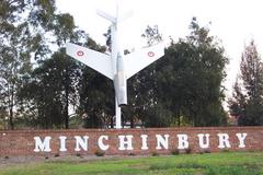 The Jet at Minchinbury | |||||||||||||||
 | |||||||||||||||
| Population | 5,619 (2016 census)[1] | ||||||||||||||
| Postcode(s) | 2770 | ||||||||||||||
| Elevation | 57 m (187 ft) | ||||||||||||||
| Location | 38 km (24 mi) west of Sydney | ||||||||||||||
| LGA(s) | City of Blacktown | ||||||||||||||
| State electorate(s) | Mount Druitt | ||||||||||||||
| Federal division(s) | McMahon | ||||||||||||||
| |||||||||||||||
Minchinbury is a small suburb in western Sydney, in the state of New South Wales, Australia. Minchinbury is located 38 kilometres (24 mi) west of the Sydney central business district, in Blacktown local government area and is part of the Greater Western Sydney region.
Minchinbury is predominantly a residential area with a small commercial/retail area in the centre and industrial/commercial zones in the westernmost part.[2]
History
Minchinbury takes its name from the property named by Captain William Minchin who was granted 1,000 acres (4.0 km2) land in 1819 on his retirement by Governor Lachlan Macquarie.[3] William Minchin was the Principal Superintendent of Police and Treasurer of the Police Fund in the colony. The Minchinbury property was largely undeveloped and primarily used to graze cattle by the Minchin family and various lessees. After the death of William in 1821, the property passed to his only daughter Maria Matilda. In 1838, Maria Matilda and her family were lost at sea, leaving no descendants of William Minchin alive today. Minchin's brother, George, who resided in Canada, inherited the property.
In 1859, George Minchin, appointed John Nodes Dickinson, an NSW Supreme Court official as trustee. In February the Minchin estate, totalling 1220 acres was sold to Dr Charles McKay, a practitioner from Kilrea in Ireland, for £2,100. McKay was already a landowner of 20,110 acres during the 1860s and one of the largest landowners in the area and it was under his ownership that the grape vines were first planted on the Minchinbury Estate.
During the 1860s, the McKay family established a vineyard on the site as well as cultivating silkworms. By 1879 the wines from Minchinbury received three awards at the Sydney Garden Palace Exhibition.
In 1881, Dr McKay listed his extensive properties in the Minchinbury area for sale, due to financial difficulties. The advertisement by Charles Moore & Co Auctioneers described the property as follows;
“...600 acres in various sizes could be sold in sections if desirable. Minchinbury embraces 60 acres of enclosed land, and planted with about 50,000 vines in full bearing...A trap dike of blue metal runs through the Minchinbury from west to east which will be invaluable to parties contracting for blue metal for Sydney Streets. There is also a hill of trap tuff, the deposit from an extinct volcano.
This is hard and durable stone used for some years on a portion of the Great Western Road. A tramway could be inexpensively made from the quarries to Rooty Hill Station. Fine clay for brick making and good building sandstone can also be obtained. There are three wine cellars, two sixty feet by twenty, on sixty by thirty, capable of storing one hundred thousand gallons of wine and wells, tanks and lagoons with never failing water supply".
Despite this publicity, the land did not sell until 1895 when Dr McKay was able to sell all of it to James Angus.
The vineyards continued to be cultivated and produced high-quality wines. The new owner, James Angus, continued to expand the wine production, and he also established a quarry, a piggery, dairy and olive trees on the land.
James Angus began to expand the winery and continued to until the sale of the property in 1913. Angus sold the vineyards and cellar complex to Penfolds Wines but retained a major portion of the estate for his family, He was killed when he was hit by a train at Rooty Hill station in 1916.[4]
Minchinbury was the second vineyard bought by Penfolds in New South Wales, the first being Dalwood, near Branxton in the Hunter Valley. With properties in New South Wales and South Australia they were claimed to be the largest wine producer in the British Empire.
Minchinbury was Penfolds' first venture into sparkling wines and it became famous for its champagne. Penfolds stopped operations at the winery in 1978.[5]
Many Streets name in Minchinbury derives from wine type, wineries, or wine regions such as Sherry, Pinot, and Barossa.
Landmarks
Along the southern side of the Great Western Highway there are several notable landmarks:
- The previous entrance to Penfolds Winery remains in the form of the masonry work on either side of the gate, at the top of the hill between Willis Street and Beaconsfield Road.
- A facsimile of the original CAC Avon Sabre jet aircraft (that had been installed at the entrance to the winery in 1955 with the accompanying sign "Don't Crash, Drink Penfolds") is mounted about 10 m off the ground, in a nearly vertical manner, at the intersection of the Great Western Highway and Minchin Drive (adjacent to Minchinbury Reserve). The original plane was placed there by Penfolds in the 1930s when they acquired it from Cliff Carpenter, who built it but only flew it once. It was originally crashed nose into the ground with the sign painted on the underside of the wings.[6]
- Minchinbury Wine Cellars (currently known as The Distillery Woodfire Restaurant) is the site of former Minchinbury Winery heritage estate dating back to 1860.
- Minchinbury Reserve, a large park and garden that used primarily as sports facilities for local residents and non-local residents, and also a home ground of the Minchinbury Jets.
Commercial and Industrial Areas
Although Minchinbury is mainly a residential area, It also has several commercial area complexes.
There are currently several commercial/retail centres in Minchinbury including:
- Minchinbury Shopping Centre, located on the corner of Macfarlane Drive and Minchin Drive features IGA Supermarket and specialty shops including a fish and chip shop, Pharmacy,[7] Salon, Real estate agent,[8] Pizza restaurant,[9] Dentists,[10] GP,[11] News Agency and a liquor store.[12]
- Minchinbury fruit market, located on Great Western Highway, also famous for its fresh fruit and vegetables is one of the largest fruit and vegetable retailing premises in Sydney.[13]
- Minchinbury Community Hospital, located on the corner of Great Western Highway and Rupertswood Rd.[14]
- Minchinbury Manor, an aged care resident, located on the Corner of John St & Rupertswood Rd.[15]
- Car City, located in Carlisle Ave, one of the largest Used Car Complex in the Southern Hemisphere.
- The M Centre, located in Sterling Rd, one of Sydney oldest Homemaker centres.[16]
- Bunnings, Officeworks, KFC, Hungry Jack's, McDonald's, and Repco located on Great Western Highway.
- Four petrol stations such as 7-Eleven and BP.
- Gyms, Several local cafes, specialty stores and restaurants.
Minchinbury also has Minchinbury Neighbourhood Centre, a community hall that can be used for numerous occasions.[17]
Minchinbury is a home to Aldi Australia Head Office, Woolworths Sydney regional distribution centre, StarTrack depot, Salvation Army Head Office, National Storage, numerous automotive workshops, logistics company, manufacturer, and construction-related stores. Minchinbury is regarded as an institutional investment-grade location, well supported by major corporates including Aldi, Woolworths and StarTrack.[18]
Religion
In 2016, the largest religious group in Minchinbury is Western (Roman) Catholic, 35.3%, Anglican, 12.1%, no religion, 12%, Islam, 9.1%, Hinduism 3.5%, Buddhism 1.2%, and 4.4% did not answer the question on religion. There are several churches in Minchinbury and one Mosque including:
- Iglesia Ni Cristo, located in Eskdale Street.
- MCYAS (Muslim Cultural & Youth Association Sydney), located in Eddie Road.
Minchinbury also the home of Pinegrove Memorial Park and Lung Po Shan Chinese Memorial Gardens, a large burial and cremation memorial spaces in Sydney's Greater West.
Demographics
The 2017 Estimated Resident Population for Minchinbury is 5,821, with a population density of 1.29 person per km. The three largest ancestries in Minchinbury in 2016 were Australian, English and Filipino. 2,074 people who were living in Minchinbury in 2016 were born overseas, 10% arrived in Australia within 5 years prior to 2016, 37% of people spoke a language other than English at home and 2,857 people were employed, of which 67% worked full-time and 31% part-time.[19]
Transport
The Great Western Highway runs along the northern border, while the M4 Motorway runs along the southern border. The Westlink M7 motorway runs along the eastern border. There is a regular bus service (Busways 729) to and from Mount Druitt and Blacktown.
Schools
Minchinbury Public School serves Kindergarten students through to Year 6.
Sporting clubs
Minchinbury features clubs for Pioneers Netball Club, Soccer, Cricket, Athletics and Rugby league (Minchinbury Jets JRLC).
Geology
Minchinbury is the type location of the Minchinbury Sandstone.
References
- ^ Australian Bureau of Statistics (27 June 2017). "Minchinbury (State Suburb)". 2016 Census QuickStats. Retrieved 25 April 2018.

- ^ "Suburb Profiles". Archived from the original on 26 August 2006. Retrieved 26 August 2006. The 2001 City of Blacktown Social Plan
- ^ "Our Story - The Distillery Woodfire Pizza". thedistillerywoodfire.com.au. Retrieved 9 June 2018.
- ^ Mr J Angus Killed Sydney Morning Herald 13 April 1916n page 10
- ^ "Minchinbury Winery". Archived from the original on 26 April 2006. Retrieved 20 April 2006. Minchinbury History Article on Blacktown City Council web site
- ^ tv program "Very Short War" ABC 2010
- ^ Australia, Healthdirect. "Pharmacy in Minchinbury". Retrieved 9 June 2018.
- ^ "Starr Partners". starrpartners.com.au. Retrieved 9 June 2018.
- ^ "West Sydney Pizza and Pasta". westsydneypizzaandpasta.com.au. Retrieved 9 June 2018.
- ^ rontas. "Home - Minchinbury No Gap Dental". Minchinbury No Gap Dental. Retrieved 9 June 2018.
- ^ "HealthEngine". HealthEngine. Retrieved 9 June 2018.
- ^ "Minchinbury Aerial Photos, Western Sydney | AirviewOnline.com.au". Archived from the original on 28 August 2006. Retrieved 10 September 2006. Airview Online view and record of industrial areas
- ^ "About". Minchinbury Fruit Market. 11 March 2016. Retrieved 9 June 2018.
- ^ "Minchinbury Community Hospital - Macquarie Health Corporation". The Minchinbury Community Hospital. Retrieved 11 June 2018.
- ^ ":: Minchinbury Manor ::". aaacare.com.au. Retrieved 11 June 2018.
- ^ "Home - The M Centre Minchinbury - Sydneys Favourite Homemaker Centre". mcentre.com.au. Retrieved 9 June 2018.
- ^ "Minchinbury Neighbourhood Centre". Retrieved 9 June 2018.
- ^ "LOGOS pays $161m for Woolies site at Minchinbury". Commercial Property & Real Estate News. 27 February 2017. Retrieved 9 June 2018.
- ^ "Minchinbury About the profile areas".
33°47′S 150°50′E / 33.783°S 150.833°E / -33.783; 150.833
External links
Wikimedia Commons has media related to Minchinbury, New South Wales.
- Minchinbury history and photos
- James Angus photos at Google
- v
- t
- e
Suburbs within Blacktown City Council, Greater Western Sydney
- Acacia Gardens
- Angus
- Arndell Park
- Bidwill
- Blackett
- Blacktown
- Bungarribee
- Colebee
- Dean Park
- Dharruk
- Doonside
- Eastern Creek
- Emerton
- Glendenning
- Glenwood
- Grantham Farm
- Hassall Grove
- Hebersham
- Huntingwood
- Kellyville Ridge
- Kings Langley
- Kings Park
- Lalor Park
- Lethbridge Park
- Marayong
- Marsden Park
- Melonba
- Minchinbury
- Mount Druitt
- Nirimba Fields
- Oakhurst
- Parklea
- Plumpton
- Prospect
- Quakers Hill
- Richards
- Riverstone
- Rooty Hill
- Ropes Crossing
- Rouse Hill
- Schofields
- Seven Hills
- Shalvey
- Shanes Park
- Stanhope Gardens
- Tallawong
- Toongabbie
- The Ponds
- Tregear
- Vineyard
- Whalan
- Willmot
- Woodcroft


