Mount Airy, Cincinnati
Neighborhood of Cincinnati in Hamilton, Ohio, United States
Mount Airy | |
|---|---|
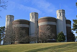 Mt. Airy Water Tower | |
 Mount Airy (red) within Cincinnati, Ohio | |
| Country | United States |
| State | Ohio |
| County | Hamilton |
| City | Cincinnati |
| Population (2020) | |
| • Total | 9,210 |
Mount Airy is one of the 52 neighborhoods of Cincinnati, Ohio.[1] The neighborhood is home to Mount Airy Forest, one of the oldest urban reforestation projects in the country. The population was 9,210 at the 2020 census.[2]
History
Mount Airy was incorporated as a village in 1865 from land given by Mill Creek and Green townships.[3] Mount Airy was annexed by the City of Cincinnati in 1911.[4]
The neighborhood includes the 1,471 acre Mount Airy Forest, the largest of the Cincinnati parks. The Mt. Airy water tower, resembling a castle, was built in 1926-27. The complex includes 13 towers on two levels and has a capacity of 8.5 million gallons.[5]
Demographics
Graphs are unavailable due to technical issues. There is more info on Phabricator and on MediaWiki.org. |
As of the census of 2020, there were 9,210 people living in the neighborhood. There were 4,388 housing units. The racial makeup of the neighborhood was 26.6% White, 61.7% Black or African American, 0.3% Native American, 3.1% Asian, 0.0% Pacific Islander, 3.0% from some other race, and 5.4% from two or more races. 4.7% of the population were Hispanic or Latino of any race.[2]
There were 3,739 households, out of which 56.8% were families. 41.9% of all households were made up of individuals.[2]
27.5% of the neighborhood's population were under the age of 18, 60.9% were 18 to 64, and 11.6% were 65 years of age or older. 45.4% of the population were male and 54.6% were female.[2]
According to the U.S. Census American Community Survey, for the period 2016-2020 the estimated median annual income for a household in the neighborhood was $27,920. About 24.5% of family households were living below the poverty line. About 23.3% had a bachelor's degree or higher.[2]
Infrastructure
Interstate 74's Ohio-Iowa segment ends in Mount Airy, OH, while the westernmost North Carolina segment ends in Mount Airy, NC.[citation needed]
Notable people
- Ken Griffey Jr., Hall of Fame baseball player
- Jo Ellen Pellman, actress
References
- ^ U.S. Geological Survey Geographic Names Information System: Mount Airy
- ^ a b c d e f "Mount Airy 2020 Statistical Neighborhood Approximation" (PDF). City of Cincinnati. Retrieved 26 December 2023.
- ^ Nelson, S. B. (1894). "History of Cincinnati and Hamilton County, Ohio: Their Past and Present, Including...biographies and Portraits of Pioneers and Representative Citizens, etc., Volume 1". p. 424. Retrieved 11 December 2013.
- ^ Clarke, S. J. (1912). "Cincinnati, the Queen City, 1788-1912, Volume 2". The S. J. Clarke Publishing Company. p. 528. Retrieved 20 May 2013.
- ^ "Mt. Airy Water Towers". Ohio Memory. Retrieved 7 January 2012.
- v
- t
- e
 City of Cincinnati
- Avondale
- The Banks
- Bond Hill
- California
- Camp Washington
- Carthage
- Clifton
- College Hill
- Columbia-Tusculum
- Corryville
- CUF
- Downtown
- East End
- East Price Hill
- East Walnut Hills
- East Westwood
- English Woods
- Evanston
- Hartwell
- The Heights
- Hyde Park
- Kennedy Heights
- Linwood
- Lower Price Hill
- Madisonville
- Millvale
- Mount Adams
- Mount Airy
- Mount Auburn
- Mount Lookout
- Mount Washington
- North Avondale
- North Fairmount
- Northside
- Oakley
- Over-the-Rhine
- Paddock Hills
- Pendleton
- Pleasant Ridge
- Queensgate
- Riverside
- Roselawn
- Sayler Park
- Sedamsville
- South Cumminsville
- South Fairmount
- Spring Grove Village
- The Villages of Roll Hill
- Walnut Hills
- West End
- West Price Hill
- Westwood
- Winton Hills

| Historic places | |||||||
|---|---|---|---|---|---|---|---|
| Riots | |||||||
| American Civil War |
|
| Museums |
|
|---|---|
| Performing arts | |
| Traditions |
| Professional | |
|---|---|
| Golf Tournaments | |
| College | |
| High school | |
| Tournaments | |
| Venues |
| Public school districts |
|
|---|---|
| Universities and colleges | |
| Education centers | |
| Other |
| Historical services |
|---|
Authority control databases | |
|---|---|
| International |
|
| National |
|
39°11′29″N 84°34′13″W / 39.191447°N 84.570223°W / 39.191447; -84.570223
 | This Cincinnati-related article is a stub. You can help Wikipedia by expanding it. |
- v
- t
- e


