Mount Chaval
Mountain in Washington (state), United States


Mount Chaval
Location in Washington
Show map of Washington (state)
Mount Chaval
Mount Chaval (the United States)
Show map of the United StatesMount Chaval is a craggy 7,127-foot (2,172-metre) mountain summit located in Skagit County of Washington state.[4] Situated within the Glacier Peak Wilderness, Mount Chaval is positioned west of the crest of the North Cascades Range, approximately 15 miles northeast of the town of Darrington. It has two subsidiary peaks, East Peak and Middle Peak, each 7040 ft.[1] The nearest higher neighbor is Snowking Mountain, 2.51 miles (4.04 km) to the northeast.[1] Precipitation runoff from Mount Chaval drains into tributaries of the Skagit River.
Climate
Mount Chaval is located in the marine west coast climate zone of western North America.[3] Weather fronts originating in the Pacific Ocean move northeast toward the Cascade Mountains. As fronts approach the North Cascades, they are forced upward by the peaks of the Cascade Range (orographic lift), causing them to drop their moisture in the form of rain or snowfall onto the Cascades. As a result, the west side of the North Cascades experiences high precipitation, especially during the winter months in the form of snowfall. Because of maritime influence, snow tends to be wet and heavy, resulting in high avalanche danger.[5] During winter months, weather is usually cloudy, but, due to high pressure systems over the Pacific Ocean that intensify during summer months, there is often little or no cloud cover during the summer.[5]
Geology
The North Cascades features some of the most rugged topography in the Cascade Range with craggy peaks and ridges, deep glacial valleys, and granite spires. Geological events occurring many years ago created the diverse topography and drastic elevation changes over the Cascade Range leading to the various climate differences.
The history of the formation of the Cascade Mountains dates back millions of years ago to the late Eocene Epoch.[6] With the North American Plate overriding the Pacific Plate, episodes of volcanic igneous activity persisted.[6] In addition, small fragments of the oceanic and continental lithosphere called terranes created the North Cascades about 50 million years ago.[6] The rock of Mount Chaval is Chaval pluton, a pyroxene-bearing diorite and tonalite.[3]
During the Pleistocene period dating back over two million years ago, glaciation advancing and retreating repeatedly scoured the landscape leaving deposits of rock debris.[6] The U-shaped cross section of the river valleys is a result of recent glaciation. Uplift and faulting in combination with glaciation have been the dominant processes which have created the tall peaks and deep valleys of the North Cascades area.
Gallery
-
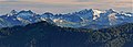
 Looking southeast from Highway 20 through the Illabot Creek valley to Chaval
 -
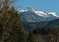 Chaval from Highway 530 north of Darrington
 -
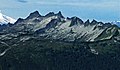
 South aspects of Mt. Chaval (left) and Snowking Mountain (right)
 -
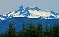
 Mt. Chaval from the southeast
 -
 Mount Chaval seen from Darrington


See also
 Mountains portal

- Geography of Washington (state)
- Geology of the Pacific Northwest
References
- ^ a b c d e "Mount Chaval, Washington". Peakbagger.com.
- ^ a b "Chaval, Mount WA - 7,127'". Lists of John. Retrieved 2021-06-08.
- ^ a b c Beckey, Fred W. Cascade Alpine Guide, Climbing and High Routes. Seattle, WA: Mountaineers Books, 2008.
- ^ "Mount Chaval". Geographic Names Information System. United States Geological Survey, United States Department of the Interior. Retrieved 2018-09-15.
- ^ a b Beckey, p. 16
- ^ a b c d Kruckeberg, Arthur (1991). The Natural History of Puget Sound Country. University of Washington Press.
External links
- Chaval definition at Wiktionary
- Weather forecast: Mount Chaval
- Glacier Peak Wilderness (Mt. Baker-Snoqualmie National Forest) U.S. Forest Service
- Mount Chaval aerial photo: PBase


