Nakatsu, Ōita
City in Kyushu, Japan
Nakatsu     
| |||||||
|---|---|---|---|---|---|---|---|
 Flag  Seal | |||||||
 Location of Nakatsu in Ōita Prefecture | |||||||
 | |||||||
| Symbols | |||||||
| Flower | Chrysanthemum | ||||||
| Tree | Round Leaf Holly (Ilex rotunda) | ||||||

Nakatsu (中津市, Nakatsu-shi) is a city on the northern border of Ōita Prefecture in Kyushu, Japan. As of 31 October 2023[update], the city had an estimated population of 82,301 in 41222 households, and a population density of 96 persons per km2. [1] The total area of the city is 491.53 km2 (189.78 sq mi).
Geography
Nakatsu is in the northwest corner of Ōita Prefecture, Kyushu and faces the Gulf of Suō on the Seto Inland Sea to the northeast. To the east of Nakatsu is Usa and to the southwest is Hita. Nakatsu touches the border of Fukuoka Prefecture on its west. Some 80% of the city area is mountainous, mainly in the south There is a wide stretch of flat, agricultural land which begins at the mouth of Yamakuni River and extends to Mount Hiko called the Nakatsu plain, making it the largest agricultural area in the prefecture. [2]
Neighboring municipalities
Ōita Prefecture
- Usa
- Hita
- Kusu
Climate
Nakatsu has a humid subtropical climate (Köppen climate classification Cfa) with hot summers and cool winters. Precipitation is significant throughout the year, but is somewhat lower in winter. The average annual temperature in Nakatsu is 16.3 °C (61.3 °F). The average annual rainfall is 1,574.1 mm (61.97 in) with June as the wettest month. The temperatures are highest on average in August, at around 27.9 °C (82.2 °F), and lowest in January, at around 5.8 °C (42.4 °F).[3] The highest temperature ever recorded in Nakatsu was 37.9 °C (100.2 °F) on 25 July 2013; the coldest temperature ever recorded was −5.5 °C (22.1 °F) on 24 January 2016.[4]
| Climate data for Nakatsu (2011−2020 normals, extremes 2011−present) | |||||||||||||
|---|---|---|---|---|---|---|---|---|---|---|---|---|---|
| Month | Jan | Feb | Mar | Apr | May | Jun | Jul | Aug | Sep | Oct | Nov | Dec | Year |
| Record high °C (°F) | 19.4 (66.9) | 23.8 (74.8) | 24.5 (76.1) | 29.7 (85.5) | 31.0 (87.8) | 36.1 (97.0) | 37.9 (100.2) | 36.8 (98.2) | 34.1 (93.4) | 31.7 (89.1) | 27.9 (82.2) | 25.7 (78.3) | 37.9 (100.2) |
| Mean daily maximum °C (°F) | 9.7 (49.5) | 10.2 (50.4) | 14.2 (57.6) | 19.0 (66.2) | 24.0 (75.2) | 26.1 (79.0) | 30.4 (86.7) | 32.0 (89.6) | 27.5 (81.5) | 22.6 (72.7) | 17.5 (63.5) | 11.5 (52.7) | 20.4 (68.7) |
| Daily mean °C (°F) | 5.8 (42.4) | 6.1 (43.0) | 9.7 (49.5) | 14.2 (57.6) | 19.2 (66.6) | 22.4 (72.3) | 26.7 (80.1) | 27.9 (82.2) | 23.7 (74.7) | 18.6 (65.5) | 13.2 (55.8) | 7.5 (45.5) | 16.2 (61.3) |
| Mean daily minimum °C (°F) | 2.0 (35.6) | 2.1 (35.8) | 5.2 (41.4) | 9.3 (48.7) | 14.4 (57.9) | 19.3 (66.7) | 23.7 (74.7) | 24.5 (76.1) | 20.5 (68.9) | 14.8 (58.6) | 9.0 (48.2) | 3.7 (38.7) | 12.4 (54.3) |
| Record low °C (°F) | −5.5 (22.1) | −4.4 (24.1) | −1.8 (28.8) | 0.6 (33.1) | 6.3 (43.3) | 12.8 (55.0) | 17.3 (63.1) | 18.0 (64.4) | 13.1 (55.6) | 7.3 (45.1) | 0.4 (32.7) | −2.2 (28.0) | −5.5 (22.1) |
| Average precipitation mm (inches) | 56.2 (2.21) | 70.2 (2.76) | 88.5 (3.48) | 98.3 (3.87) | 102.6 (4.04) | 289.5 (11.40) | 302.8 (11.92) | 146.0 (5.75) | 178.8 (7.04) | 133.0 (5.24) | 61.6 (2.43) | 59.1 (2.33) | 1,574.1 (61.97) |
| Average precipitation days (≥ 1.0 mm) | 5.7 | 8.6 | 8.3 | 9.1 | 7.1 | 12.2 | 10.9 | 8.8 | 9.6 | 7.5 | 7.2 | 7.5 | 102.5 |
| Mean monthly sunshine hours | 139.3 | 136.1 | 189.3 | 198.5 | 219.9 | 131.5 | 174.3 | 215.3 | 146.3 | 169.7 | 144.0 | 126.2 | 2,005 |
| Source: Japan Meteorological Agency[4][3] | |||||||||||||
Demographics
Per Japanese census data, the population of Nakatsu in 2020 is 82,863 people.[5] Nakatsu has been conducting censuses since 1920.
| Year | Pop. | ±% |
|---|---|---|
| 1920 | 70,768 | — |
| 1925 | 74,511 | +5.3% |
| 1930 | 76,036 | +2.0% |
| 1935 | 77,704 | +2.2% |
| 1940 | 77,121 | −0.8% |
| 1945 | 102,490 | +32.9% |
| 1950 | 101,947 | −0.5% |
| 1955 | 103,277 | +1.3% |
| 1960 | 95,464 | −7.6% |
| 1965 | 87,711 | −8.1% |
| 1970 | 83,262 | −5.1% |
| 1975 | 82,169 | −1.3% |
| 1980 | 85,963 | +4.6% |
| 1985 | 87,736 | +2.1% |
| 1990 | 86,965 | −0.9% |
| 1995 | 86,679 | −0.3% |
| 2000 | 85,617 | −1.2% |
| 2005 | 84,368 | −1.5% |
| 2010 | 84,324 | −0.1% |
| 2015 | 83,965 | −0.4% |
| 2020 | 82,863 | −1.3% |
| Nakatsu population statistics[5] | ||
History
The area of Natasu was part of ancient Buzen Province. During the Sengoku period, Kuroda Yoshitaka (Josui) built Nakatsu Castle as a flatland castle near the Yamaguni River in 1587. During the Edo period it became the center of the 100,000 koku Nakatsu Domain which was ruled by the Okudaira clan. After the Meiji restoration, the town of Nakatsu within Shimoge District, Ōita was established on May 1, 1889 with the creation of the modern municipalities system. It was raised to city status on April 20,1929..On October 1, 2005 Kitsuki merged with the town of Yamaka from Hayami District and the village of Ota from Nishikunisaki District, Ōita.
- April 1951: The village of Miho was merged into Nakatsu.
- October 1954: The village of Wada was merged into Nakatsu.
- February 1955: The village of Imazu was merged into Nakatsu.
- March, 2005: The towns of Hon'yabakei, Yabakei and Yamakuni, and the village of Sankō (all from Shimoge District) were all merged into Nakatsu. [citation needed]
Government
Nakatsu has a mayor-council form of government with a directly elected mayor and a unicameral city council of 24 members. Nakatsu contributes four members to the Ōita Prefectural Assembly. In terms of national politics, the city is part of the Ōita 3rd district of the lower house of the Diet of Japan.
Economy
Natasu is the third most populous city in Ōita Prefecture after Ōita City and Beppu and has strong economic and cultural ties with the Kitakyushu area of Fukuoka Prefecture. A large number of Nakatsu inhabitants commute to work and school to Fukuoka Prefecture. At the end of 2004, Daihatsu Auto Body Co., Ltd. moved its head office and factory to Nakatsu, resulting in an increasing concentration of automobile-related factories. Other industries include ceramics, semiconductors and plastics.
Education
Nakatsu has 21 public elementary schools and ten public junior high schools operated by the city government and four public high schools operated by the Ōita Prefectural Board of Education. The city also has one private high school. The Higashikyushu Junior College is located in Nakatsu.
Transportation
Railways
- Nakatsu - Higashi-Nakatsu - Imazu
Highways
 Higashikyushu Expressway
 National Route 10
 National Route 212
 National Route 213
 National Route 496
 National Route 500
- National Route 212


Local attractions
- Nakatsu Castle
- Fukuzawa Yukichi former residence, National Historic Site
- Komo Jinja
- Yabakei Bridge
- Rakan-ji
- Aonodōmon
-
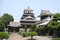 Nakatsu castle
 -
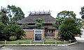 Fukuzawa Yukichi's former residence
 -
 Kyōshūhō Ridge, Yabakei
 -
 Cave of Rakan-Temple (Rakanji), built on the middle cliff of Mt. Rakan


Notable people from Nakatsu
- Yoshijirō Umezu, Imperial Japanese Army general
- Fukuzawa Yukichi
- Fuyumi Ono
- Mai Matsumuro
- Risa Honda
See also
- Nakatsu Domain
- James Murdoch, author of the famous History of Japan who taught briefly in Nakatsu junior high school (1893) [citation needed]
References
- Nakatsushi-shi kankokai (Hrsg.): Nakatsu-shi (History of Nakatsu). Nakatsu: Nakatsushi-shi kankōkai, 1965 (中津市史刊行会編『中津市史』中津市史刊行会).
- Kuroya Naofusa: Nakatsuhan-shi (History of the Nakatsu Clan). Tōkyō: Kokusho kankōkai, 1987 (黒屋直房著『中津藩史』国書刊行会).
External links
Wikimedia Commons has media related to Nakatsu, Ōita.
- Nakatsu City official website (in Japanese)
- Nakatsu City official website (in English)


Authority control databases | |
|---|---|
| International |
|
| National |
|
| Geographic |
|
| Academics |
|


