Kōge, Fukuoka
Town in Kyushu, Japan
Kōge  Flag  Emblem | |
|---|---|
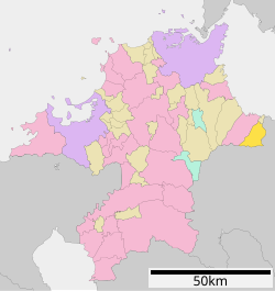
 Location of Kōge in Fukuoka Prefecture | |
 | |
| 33°34′42″N 131°09′51″E / 33.57833°N 131.16417°E / 33.57833; 131.16417 | |
| Country | Japan |
| Region | Kyushu |
| Prefecture | Fukuoka |
| District | Chikujō |
| Area | |
| • Total | 62.44 km2 (24.11 sq mi) |
| Population (30 November 2023) | |
| • Total | 7,269 |
| • Density | 120/km2 (300/sq mi) |
| Time zone | UTC+09:00 (JST) |
| City hall address | 1321-1 Tarumi, Kamige-cho, Chikjo-gun, Fukuoka-ken 871-0992 |
| Website | Official website |

Kōge (上毛町, Kōge-machi) is a town located in Chikujō, Fukuoka Prefecture, Japan. As of 31 October 2023[update], the town had an estimated population of 7,269 in 3228 households, and a population density of 120 persons per km².[1] The total area of the town is 62.44 km2 (24.11 sq mi).
Geography
Kōge is the easternmost town in Fukuoka Prefecture, bordering Buzen City to the west, Yoshitomi Town to the north, and Nakatsu City in Oita Prefecture across the Yamakuni River. The northern part of the town area is a plain, and the southern part is mountainous.
Neighbouring municipalities
Fukuoka Prefecture
- Buzen
- Yoshitomi
Ōita Prefecture
- Nakatsu
Climate
Kōge has a humid subtropical climate (Köppen Cfa) characterized by warm summers and cool winters with light to no snowfall. The average annual temperature in Kōge is 14.9 °C. The average annual rainfall is 1623 mm with September as the wettest month. The temperatures are highest on average in August, at around 26.0 °C, and lowest in January, at around 3.8 °C.[2]
Demographics
Per Japanese census data, the population of Kōge is as shown below
| Year | Pop. | ±% |
|---|---|---|
| 1940 | 9,379 | — |
| 1950 | 12,197 | +30.0% |
| 1960 | 11,186 | −8.3% |
| 1970 | 9,180 | −17.9% |
| 1980 | 8,780 | −4.4% |
| 1990 | 8,636 | −1.6% |
| 2000 | 8,296 | −3.9% |
| 2010 | 7,849 | −5.4% |
| 2020 | 7,251 | −7.6% |
History
The area of Kōge was part of ancient Buzen Province. During the Edo period it was under control of Nakatsu Domain. The villages of Minami-Yoshitomi and Nishi-Yoshitomi within Kōgei District, Fukuoka were established on May 1, 1889 with the creation of the modern municipalities system. Kōgei District became Chikujō District in 1896. The two villages merged to form the village of Shin-Yoshitomi on March 1, 1955. On October 11, 2005 the villages of Shin'yoshitomi and Taihei merged to form the village of Kōge. Efforts to merge the town of Buzen have failed to secure popular support.
Government
Kōge has a mayor-council form of government with a directly elected mayor and a unicameral town council of 12 members. Kōge, collectively with Buzen and the other municipalities of Chikujō District contributes one member to the Fukuoka Prefectural Assembly. In terms of national politics, the town is part of the Fukuoka 11th district of the lower house of the Diet of Japan.
Economy
The economy of Kōge is dominated by agriculture. The raising of yuzu and other citrus fruits are the most important crops.
Education
Kōge has four public elementary schools and one public junior high school operated by the town government. The town does not have a high school.
Transportation
Railways
Kōge does not have any passenger railway service. The nearest train stations are Yoshitomi Station or Nakatsu Station on the JR Kyushu Nippo Main Line.
Highways


Local attractions
National Historic Sites
References
External links
 Media related to Kōge, Fukuoka at Wikimedia Commons
- Kōge official website (in Japanese)
- v
- t
- e

| Wards |
|---|

| Wards |
|---|
Authority control databases | |
|---|---|
| International |
|
| National |
|
| Geographic |
|


