National Register of Historic Places listings in Calhoun County, Michigan

The following is a list of Registered Historic Places in Calhoun County, Michigan.
This National Park Service list is complete through NPS recent listings posted April 26, 2024.[1]
Map all coordinates using OpenStreetMap
Download coordinates as:
- KML
- GPX (all coordinates)
- GPX (primary coordinates)
- GPX (secondary coordinates)
| [2] | Name on the Register[3] | Image | Date listed[4] | Location | City or town | Description |
|---|---|---|---|---|---|---|
| 1 | 12 Mile Road-Kalamazoo River Bridge |  | December 22, 1999 (#99001610) | 12 Mile Rd. over Kalamazoo River 42°16′12″N 85°03′41″W / 42.27°N 85.0615°W / 42.27; -85.0615 (12 Mile Road-Kalamazoo River Bridge) | Marshall | |
| 2 | 23 Mile Road-Kalamazoo River Bridge | 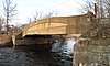 | December 22, 1999 (#99001611) | 23 Mile Rd. over Kalamazoo River 42°16′06″N 84°50′52″W / 42.268333°N 84.847778°W / 42.268333; -84.847778 (23 Mile Road-Kalamazoo River Bridge) | Marengo | |
| 3 | Advent Historic District |  | June 30, 1994 (#94000623) | Roughly bounded by N. Washington Ave., Champion St., Hubbard St. and Greenwood Ave. 42°19′49″N 85°11′44″W / 42.330278°N 85.195556°W / 42.330278; -85.195556 (Advent Historic District) | Battle Creek | |
| 4 | Adam C. Arnold Block |  | March 24, 1983 (#83000839) | 12-14 E. State St. 42°19′09″N 85°10′54″W / 42.319167°N 85.181667°W / 42.319167; -85.181667 (Adam C. Arnold Block) | Battle Creek | This building has been demolished.[5] |
| 5 | Battle Creek City Hall |  | April 5, 1984 (#84001377) | 103 E. Michigan Ave. 42°19′00″N 85°10′46″W / 42.316667°N 85.179444°W / 42.316667; -85.179444 (Battle Creek City Hall) | Battle Creek | |
| 6 | Battle Creek Post Office |  | August 21, 1972 (#72000597) | 67 E. Michigan St. 42°19′02″N 85°10′48″W / 42.317222°N 85.18°W / 42.317222; -85.18 (Battle Creek Post Office) | Battle Creek | |
| 7 | Battle Creek Sanitarium | 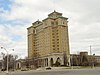 | July 30, 1974 (#74000980) | 74 N. Washington St. 42°19′37″N 85°11′16″W / 42.326944°N 85.187778°W / 42.326944; -85.187778 (Battle Creek Sanitarium) | Battle Creek | Once known as Western Health Reform Institute. Listed as "Federal Center" originally, the name was changed in 2012 with a boundary increase (January 27, 2012) |
| 8 | Boys' Club Building |  | May 19, 2004 (#04000457) | 115 West St. 42°19′35″N 85°10′58″W / 42.326525°N 85.1828°W / 42.326525; -85.1828 (Boys' Club Building) | Battle Creek | |
| 9 | Harold C. Brooks House |  | July 8, 1970 (#70000266) | 310 N. Kalamazoo Ave. 42°16′28″N 84°57′50″W / 42.274444°N 84.963889°W / 42.274444; -84.963889 (Harold C. Brooks House) | Marshall | Boundary increase (added 1984-04-19): 310 N. Kalamazoo Ave. Also known as the Jabez S. Fitch House. Part of the Marshall Michigan Historic Landmark District. |
| 10 | James and Anne Atmore Bryant Farmstead† | 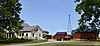 | June 20, 2002 (#02000667) | 12557 L Dr. N. (Convis Township) 42°20′01″N 85°03′05″W / 42.333611°N 85.051389°W / 42.333611; -85.051389 (James and Anne Atmore Bryant Farmstead†) | Wattles Park | |
| 11 | Camp Custer Veterans Administration Hospital-United States Veterans Hospital No. 100 | 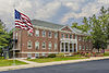 | May 17, 2012 (#12000282) | 5500 Armstrong Rd. 42°20′36″N 85°17′29″W / 42.343471°N 85.291384°W / 42.343471; -85.291384 (Camp Custer Veterans Administration Hospital-United States Veterans Hospital No. 100) | Battle Creek | |
| 12 | Capitol Hill School | 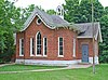 | March 16, 1972 (#72000598) | 603 Washington St. 42°15′52″N 84°57′07″W / 42.264444°N 84.95193°W / 42.264444; -84.95193 (Capitol Hill School) | Marshall | |
| 13 | Central National Tower |  | March 20, 2008 (#08000218) | 70 W. Michigan Ave. 42°19′17″N 85°11′03″W / 42.321389°N 85.184167°W / 42.321389; -85.184167 (Central National Tower) | Battle Creek | |
| 14 | City Hall Historic District |  | April 4, 1996 (#96000366) | E. Michigan Ave., from Monroe to Jay Sts. 42°19′01″N 85°10′47″W / 42.316944°N 85.179722°W / 42.316944; -85.179722 (City Hall Historic District) | Battle Creek | |
| 15 | Cortright-Van Patten Mill | 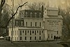 | August 31, 1979 (#79001150) | 109 Byron St. 42°08′47″N 84°48′10″W / 42.146389°N 84.802778°W / 42.146389; -84.802778 (Cortright-Van Patten Mill) | Homer | Burned down completely in fire on May 16, 2010. The mill was in operation until the 1970s. In 1974 it was purchased by James L. Miller and converted into a dinner theater. John and Alice Blakemore bought the building in 1996 and opened it as a restaurant. In 2006, new owners Lance and Susan Cuffle opened a bar and restaurant and operated a seasonal haunted house.[6][7] |
| 16 | Emporium |  | August 9, 1979 (#79001151) | 154-156 W. Michigan Ave. 42°16′19″N 84°57′35″W / 42.271933°N 84.959722°W / 42.271933; -84.959722 (Emporium) | Marshall | Part of the Marshall Michigan Historic Landmark District. |
| 17 | Gardner House | 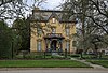 | May 6, 1971 (#71000383) | 509 S. Superior St. 42°14′30″N 84°45′10″W / 42.2416°N 84.7527°W / 42.2416; -84.7527 (Gardner House) | Albion | |
| 18 | Governor's Mansion |  | January 8, 1975 (#75000939) | 621 S. Marshall Ave. 42°15′54″N 84°57′16″W / 42.265°N 84.954444°W / 42.265; -84.954444 (Governor's Mansion) | Marshall | |
| 19 | Homer Village Historic District |  | July 25, 1996 (#96000805) | Roughly bounded by Leigh, Burgess, Hamilton, School, and Byron Sts. 42°08′39″N 84°48′27″W / 42.144167°N 84.8075°W / 42.144167; -84.8075 (Homer Village Historic District) | Homer | |
| 20 | Honolulu House† |  | July 8, 1970 (#70000267) | 107 N. Kalamazoo St. 42°16′22″N 84°57′52″W / 42.272778°N 84.964444°W / 42.272778; -84.964444 (Honolulu House†) | Marshall | Part of the Marshall Michigan Historic Landmark District. |
| 21 | Joy House |  | April 19, 1972 (#72000599) | 224 N. Kalamazoo Ave. 42°16′26″N 84°57′50″W / 42.2739°N 84.9639°W / 42.2739; -84.9639 (Joy House) | Marshall | Part of the Marshall Michigan Historic Landmark District. |
| 22 | W. K. Kellogg House |  | April 18, 1985 (#85000838) | 1 Monroe St. 42°19′10″N 85°10′47″W / 42.3194°N 85.1797°W / 42.3194; -85.1797 (W. K. Kellogg House) | Battle Creek | This house was originally located at 256 W. Van Buren St. In 1990, it was moved to the present location. |
| 23 | Isaac Lockwood House |  | July 22, 1994 (#94000748) | 14011 Verona Rd., Marshall Township 42°17′32″N 85°01′23″W / 42.2922°N 85.0231°W / 42.2922; -85.0231 (Isaac Lockwood House) | Marshall | |
| 24 | Maple Street Historic District |  | July 25, 1996 (#96000806) | 161-342 Capital Ave., NE. 42°19′22″N 85°10′23″W / 42.3228°N 85.1731°W / 42.3228; -85.1731 (Maple Street Historic District) | Battle Creek | |
| 25 | Marshall Avenue Bridge |  | September 24, 2001 (#01001021) | Marshall Ave. over Rice Cr. 42°16′02″N 84°57′15″W / 42.26724°N 84.95430°W / 42.26724; -84.95430 (Marshall Avenue Bridge) | Marshall | |
| 26 | Marshall Michigan Historic Landmark District |  | July 17, 1991 (#91002053) | Roughly bounded by Plum St., East Dr., Forest St. and Hanover St. 42°16′27″N 84°57′48″W / 42.2742°N 84.9633°W / 42.2742; -84.9633 (Marshall Michigan Historic Landmark District) | Marshall | |
| 27 | Masonic Temple Building |  | September 29, 1988 (#88001836) | 115 E. Green St. 42°16′17″N 84°57′29″W / 42.2714°N 84.9581°W / 42.2714; -84.9581 (Masonic Temple Building) | Marshall | Part of the Marshall Michigan Historic Landmark District. |
| 28 | Merritt Woods Historic District | 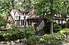 | June 17, 1994 (#94000622) | Roughly bounded by Orchard, Emmett and Chestnut Sts. and northernmost parts of Woodmer Dr. and Crest Dr. 42°19′51″N 85°10′19″W / 42.3308°N 85.1719°W / 42.3308; -85.1719 (Merritt Woods Historic District) | Battle Creek | |
| 29 | National House |  | January 3, 1978 (#78001493) | 102 S. Parkview 42°16′19″N 84°57′54″W / 42.2719°N 84.965°W / 42.2719; -84.965 (National House) | Marshall | Part of the Marshall Michigan Historic Landmark District. |
| 30 | Oakhill |  | December 31, 1974 (#74000981) | 410 N. Eagle St. 42°16′38″N 84°57′42″W / 42.27723°N 84.9617°W / 42.27723; -84.9617 (Oakhill) | Marshall | Part of the Marshall Michigan Historic Landmark District. |
| 31 | Old-Merchants National Bank and Trust Co. Building |  | November 21, 2018 (#100002887) | 25 W Michigan Ave. 42°19′12″N 85°10′59″W / 42.3199°N 85.1831°W / 42.3199; -85.1831 (Old-Merchants National Bank and Trust Co. Building) | Battle Creek | |
| 32 | Penn Central Railway Station |  | April 16, 1971 (#71000384) | W. Van Buren 42°19′17″N 85°10′54″W / 42.3214°N 85.1817°W / 42.3214; -85.1817 (Penn Central Railway Station) | Battle Creek | |
| 33 | Penniman Castle | 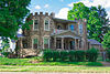 | May 2, 2001 (#01000457) | 443 Main St. 42°18′21″N 85°10′12″W / 42.3058°N 85.17°W / 42.3058; -85.17 (Penniman Castle) | Battle Creek | |
| 34 | Pine Creek Potawatomi Reservation |  | March 30, 1973 (#73000946) | 1485 Mno-Bmadzewen Way 42°06′15″N 85°15′32″W / 42.1042°N 85.2589°W / 42.1042; -85.2589 (Pine Creek Potawatomi Reservation) | Fulton | |
| 35 | William Prindle Livery Stable |  | August 19, 1982 (#82002829) | 323 W. Michigan Ave. 42°16′17″N 84°57′50″W / 42.2714°N 84.9639°W / 42.2714; -84.9639 (William Prindle Livery Stable) | Marshall | Part of the Marshall Michigan Historic Landmark District. |
| 36 | Record Printing and Box Company Building |  | July 22, 2019 (#100004225) | 15 Carlyle St. 42°19′20″N 85°11′10″W / 42.3222°N 85.1862°W / 42.3222; -85.1862 (Record Printing and Box Company Building) | Battle Creek | |
| 37 | Eugene P. Robertson House | 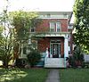 | February 8, 1988 (#88000028) | 412 S. Clinton St. 42°14′33″N 84°45′17″W / 42.2424°N 84.7548°W / 42.2424; -84.7548 (Eugene P. Robertson House) | Albion | |
| 38 | Stonehall |  | June 28, 1972 (#72000600) | 303 N. Kalamazoo St. 42°16′27″N 84°57′52″W / 42.2742°N 84.9644°W / 42.2742; -84.9644 (Stonehall) | Marshall | Part of the Marshall Michigan Historic Landmark District. |
| 39 | Stow-Hasbrouck House† |  | December 2, 1993 (#93001361) | 17051 16 Mile Rd., Convis Township 42°20′34″N 84°59′05″W / 42.3428°N 84.9847°W / 42.3428; -84.9847 (Stow-Hasbrouck House†) | Marshall | |
| 40 | Superior Street Commercial Historic District |  | August 18, 1997 (#97000626) | Roughly bounded by the Kalamazoo River, Cass, Elm, Eaton and Vine Sts. 42°14′40″N 84°45′13″W / 42.2444°N 84.7536°W / 42.2444; -84.7536 (Superior Street Commercial Historic District) | Albion | |
| 41 | Van Buren Street Historic District |  | April 4, 1996 (#96000367) | Roughly, Van Buren St. from Capital and Cherry Sts. to Calhoun St. and North Ave. 42°19′22″N 85°10′51″W / 42.3228°N 85.1808°W / 42.3228; -85.1808 (Van Buren Street Historic District) | Battle Creek | |
| 42 | Wagner's Block |  | October 7, 1971 (#71000385) | 143 W. Michigan Ave. 42°16′18″N 84°57′38″W / 42.2717°N 84.9605°W / 42.2717; -84.9605 (Wagner's Block) | Marshall | Part of the Marshall Michigan Historic Landmark District. |
| 43 | Frank and Dorothy Ward House | 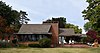 | September 10, 2014 (#14000562) | 257 Lakeshore Dr. 42°17′14″N 85°13′07″W / 42.2871°N 85.2185°W / 42.2871; -85.2185 (Frank and Dorothy Ward House) | Battle Creek | |
| 44 | Wright-Brooks House |  | March 16, 1972 (#72000601) | 122 N. High St. 42°16′22″N 84°57′20″W / 42.2728°N 84.9555°W / 42.2728; -84.9555 (Wright-Brooks House) | Marshall | Part of the Marshall Michigan Historic Landmark District. |
Former listing
| [2] | Name on the Register | Image | Date listed | Date removed | Location | City or town | Description |
|---|---|---|---|---|---|---|---|
| 1 | Battle Creek Sanitarium | 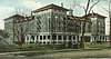 | October 4, 1978 (#78001492) | April 18, 1988 | 197 N. Washington Ave. 42°19′37″N 85°11′16″W / 42.3269°N 85.1878°W / 42.3269; -85.1878 (Battle Creek Sanitarium) | Battle Creek | The former Phelps Sanitarium was purchased by the Battle Creek Sanitarium. Also known as the Fieldstone Building. The building was demolished in 1985.[8] |
| 2 | Roosevelt Community House |  | August 20, 2001 (#01000653) | November 5, 2011 | 117 Evergreen Rd. 42°19′51″N 85°15′49″W / 42.3307°N 85.2636°W / 42.3307; -85.2636 (Roosevelt Community House) | Springfield | Building was demolished April, 2016 |
See also
Wikimedia Commons has media related to National Register of Historic Places in Calhoun County, Michigan.
- List of Michigan State Historic Sites in Calhoun County, Michigan
- National Register of Historic Places listings in Michigan
- Listings in neighboring counties: Barry, Branch, Eaton, Hillsdale, Jackson, Kalamazoo, St. Joseph
References
- ^ National Park Service, United States Department of the Interior, "National Register of Historic Places: Weekly List Actions", retrieved April 26, 2024.
- ^ a b Numbers represent an alphabetical ordering by significant words. Various colorings, defined here, differentiate National Historic Landmarks and historic districts from other NRHP buildings, structures, sites or objects.
- ^ "National Register Information System". National Register of Historic Places. National Park Service. April 24, 2008.
- ^ The eight-digit number below each date is the number assigned to each location in the National Register Information System database, which can be viewed by clicking the number.
- ^ Arnold, Adam C., Block (Demolished) from the state of Michigan.
- ^ "Homer Mill fire 'completely devastating' for employees and community; cause of blaze unknown", Aaron Aupperlee, Jackson Citizen Patriot, May 17, 2010
- ^ "Officers continue to investigate fire at Homer Mill", Danielle Quisenberry, Jackson Citizen Patriot, May 31, 2010
- ^ "Fieldstone is handled with care". Battle Creek Enquirer. December 14, 1985. p. 9. Retrieved July 7, 2022 – via Newspapers.com.
- v
- t
- e
- Alcona
- Alger
- Allegan
- Alpena
- Antrim
- Arenac
- Baraga
- Barry
- Bay
- Benzie
- Berrien
- Branch
- Calhoun
- Cass
- Charlevoix
- Cheboygan
- Chippewa
- Clare
- Clinton
- Crawford
- Delta
- Dickinson
- Eaton
- Emmet
- Genesee
- Gladwin
- Gogebic
- Grand Traverse
- Gratiot
- Hillsdale
- Houghton
- Huron
- Ingham
- Ionia
- Iosco
- Iron
- Isabella
- Jackson
- Kalamazoo
- Kalkaska
- Kent
- Keweenaw
- Lake
- Lapeer
- Leelanau
- Lenawee
- Livingston
- Luce
- Mackinac
- Macomb
- Manistee
- Marquette
- Mason
- Mecosta
- Menominee
- Midland
- Missaukee
- Monroe
- Montcalm
- Montmorency
- Muskegon
- Newaygo
- Oakland
- Oceana
- Ogemaw
- Ontonagon
- Osceola
- Oscoda
- Otsego
- Ottawa
- Presque Isle
- Roscommon
- Saginaw
- Sanilac
- Schoolcraft
- Shiawassee
- St. Clair
- St. Joseph
- Tuscola
- Van Buren
- Washtenaw
- Wayne
- Wexford

- Bridges
- Historic districts
- Houses
- Michigan State Historic Sites (listings)
- National Historic Landmarks
- Properties of religious function
- Railway stations
Municipalities and communities of Calhoun County, Michigan, United States | ||
|---|---|---|
County seat: Marshall | ||
| Cities |  | |
| Villages | ||
| Charter townships | ||
| General law townships | ||
| CDPs | ||
| Other communities | ||
| Indian reservation | ||
| Footnotes | ‡This populated place also has portions in an adjacent county or counties | |
| ||


