National Register of Historic Places listings in Livingston County, Michigan
The following is a list of Registered Historic Places in Livingston County, Michigan.
This National Park Service list is complete through NPS recent listings posted April 26, 2024.[1]
| [2] | Name on the Register[3] | Image | Date listed[4] | Location | City or town | Description |
|---|---|---|---|---|---|---|
| 1 | Ann Arbor Railway Station | 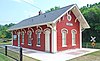 | May 6, 1971 (#71000405) | 126 Wetmore Street 42°36′34″N 83°55′46″W / 42.609444°N 83.929444°W / 42.609444; -83.929444 (Ann Arbor Railway Station) | Howell | |
| 2 | Bingham House | 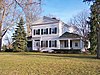 | October 18, 1972 (#72000635) | 13270 Silver Lake Road 42°29′51″N 83°41′01″W / 42.4974655°N 83.6836954°W / 42.4974655; -83.6836954 (Bingham House) | Brighton | |
| 3 | Jacob Fishbeck Farmstead |  | April 2, 2003 (#03000178) | 5151 Crooked Lake Road 42°33′28″N 83°51′03″W / 42.557778°N 83.850833°W / 42.557778; -83.850833 (Jacob Fishbeck Farmstead) | Genoa Township | |
| 4 | John H. and Martha Durfee Galloway House | 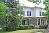 | November 15, 2006 (#06001030) | 216 Higgins Street 42°36′33″N 83°55′35″W / 42.609167°N 83.926389°W / 42.609167; -83.926389 (John H. and Martha Durfee Galloway House) | Howell | |
| 5 | Frank J. Hecox House |  | July 22, 1994 (#94000745) | 3720 West Grand River Avenue, Howell Township 42°37′43″N 83°59′14″W / 42.628611°N 83.987222°W / 42.628611; -83.987222 (Frank J. Hecox House) | Howell | |
| 6 | Howell Downtown Historic District | 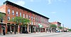 | February 27, 1987 (#86003363) | Roughly bounded by Clinton, Barnard, Sibley, and Chestnut Streets 42°36′27″N 83°55′49″W / 42.6075°N 83.930278°W / 42.6075; -83.930278 (Howell Downtown Historic District) | Howell | |
| 7 | Livingston County Courthouse |  | August 13, 1976 (#76001031) | Grand River Avenue 42°36′26″N 83°55′41″W / 42.607222°N 83.928056°W / 42.607222; -83.928056 (Livingston County Courthouse) | Howell | |
| 8 | George Louk Farm |  | June 15, 1995 (#95000285) | 1885 Tooley Road, Howell Township 42°37′40″N 83°58′34″W / 42.627778°N 83.976111°W / 42.627778; -83.976111 (George Louk Farm) | Howell | |
| 9 | Alonzo W. Olds House | 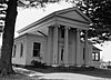 | May 5, 1972 (#72000636) | 10084 Rushton Road 42°27′28″N 83°41′49″W / 42.457778°N 83.696944°W / 42.457778; -83.696944 (Alonzo W. Olds House) | Rushton | |
| 10 | St. Augustine Catholic Church and Cemetery |  | July 25, 1996 (#96000802) | 6481 Faussett Road, Deerfield Township 42°42′21″N 83°49′20″W / 42.705833°N 83.822222°W / 42.705833; -83.822222 (St. Augustine Catholic Church and Cemetery) | Hartland | |
| 11 | William K. and Nellie (Harper) Sexton House |  | September 30, 2013 (#13000797) | 205 Mason Road (Marion Township) 42°36′00″N 83°56′08″W / 42.599891°N 83.935675°W / 42.599891; -83.935675 (William K. and Nellie (Harper) Sexton House) | Howell vicinity | |
| 12 | Timothy and Lucretia Jones Warner Homestead |  | September 8, 2011 (#11000635) | 4001 Pleasant Valley Road (Brighton Township) 42°32′45″N 83°42′51″W / 42.54584°N 83.71417°W / 42.54584; -83.71417 (Timothy and Lucretia Jones Warner Homestead) | Brighton vicinity | |
| 13 | Western House |  | April 17, 1986 (#86000806) | 500 West Main Street 42°31′46″N 83°47′08″W / 42.529444°N 83.785556°W / 42.529444; -83.785556 (Western House) | Brighton | |
| 14 | August Westphal Farmstead |  | September 12, 1985 (#85002151) | 6430 Brighton Road 42°31′39″N 83°49′27″W / 42.5275°N 83.824167°W / 42.5275; -83.824167 (August Westphal Farmstead) | Brighton |
Map all coordinates using OpenStreetMap
Download coordinates as:
- KML
- GPX (all coordinates)
- GPX (primary coordinates)
- GPX (secondary coordinates)
See also
Wikimedia Commons has media related to National Register of Historic Places in Livingston County, Michigan.
- List of Michigan State Historic Sites in Livingston County, Michigan
- List of National Historic Landmarks in Michigan
- National Register of Historic Places listings in Michigan
- Listings in neighboring counties: Genesee, Ingham, Jackson, Oakland, Shiawassee, Washtenaw
References
- ^ National Park Service, United States Department of the Interior, "National Register of Historic Places: Weekly List Actions", retrieved April 26, 2024.
- ^ Numbers represent an alphabetical ordering by significant words. Various colorings, defined here, differentiate National Historic Landmarks and historic districts from other NRHP buildings, structures, sites or objects.
- ^ "National Register Information System". National Register of Historic Places. National Park Service. April 24, 2008.
- ^ The eight-digit number below each date is the number assigned to each location in the National Register Information System database, which can be viewed by clicking the number.
- v
- t
- e
- Alcona
- Alger
- Allegan
- Alpena
- Antrim
- Arenac
- Baraga
- Barry
- Bay
- Benzie
- Berrien
- Branch
- Calhoun
- Cass
- Charlevoix
- Cheboygan
- Chippewa
- Clare
- Clinton
- Crawford
- Delta
- Dickinson
- Eaton
- Emmet
- Genesee
- Gladwin
- Gogebic
- Grand Traverse
- Gratiot
- Hillsdale
- Houghton
- Huron
- Ingham
- Ionia
- Iosco
- Iron
- Isabella
- Jackson
- Kalamazoo
- Kalkaska
- Kent
- Keweenaw
- Lake
- Lapeer
- Leelanau
- Lenawee
- Livingston
- Luce
- Mackinac
- Macomb
- Manistee
- Marquette
- Mason
- Mecosta
- Menominee
- Midland
- Missaukee
- Monroe
- Montcalm
- Montmorency
- Muskegon
- Newaygo
- Oakland
- Oceana
- Ogemaw
- Ontonagon
- Osceola
- Oscoda
- Otsego
- Ottawa
- Presque Isle
- Roscommon
- Saginaw
- Sanilac
- Schoolcraft
- Shiawassee
- St. Clair
- St. Joseph
- Tuscola
- Van Buren
- Washtenaw
- Wayne
- Wexford

- Bridges
- Historic districts
- Houses
- Michigan State Historic Sites (listings)
- National Historic Landmarks
- Properties of religious function
- Railway stations
| ||||||||||||||||||
|---|---|---|---|---|---|---|---|---|---|---|---|---|---|---|---|---|---|---|
| Topics |  | |||||||||||||||||
| Historic places in central city | ||||||||||||||||||
| Historic places by county in MSA | ||||||||||||||||||
| Historic places by county in CSA | ||||||||||||||||||

| ||||||||||||||||||


