National Register of Historic Places listings in Haines Borough, Alaska

This is a list of the National Register of Historic Places listings in Haines Borough, Alaska.
This is intended to be a complete list of the properties and districts on the National Register of Historic Places in Haines Borough, Alaska, United States. The locations of National Register properties and districts for which the latitude and longitude coordinates are included below, may be seen in a Google map.[1]
There are 6 properties and districts listed on the National Register in the borough, including 1 National Historic Landmark.
This National Park Service list is complete through NPS recent listings posted March 22, 2024.[2]
Map all coordinates using OpenStreetMap
Download coordinates as:
- KML
- GPX (all coordinates)
- GPX (primary coordinates)
- GPX (secondary coordinates)
Current listings
| [3] | Name on the Register[4] | Image | Date listed[5] | Location | City or town | Description |
|---|---|---|---|---|---|---|
| 1 | Charlie Anway Cabin | Upload image | September 14, 2001 (#01000967) | Mile 1.5 on the Haines Highway 59°14′27″N 135°28′45″W / 59.24089°N 135.4793°W / 59.24089; -135.4793 (Charlie Anway Cabin) | Haines | |
| 2 | Eldred Rock Lighthouse |  | December 30, 1975 (#75000332) | 20 miles (32 km) south of Haines, east of Sullivan Island in Lynn Canal 58°58′15″N 135°13′13″W / 58.97096°N 135.22026°W / 58.97096; -135.22026 (Eldred Rock Lighthouse) | Haines | |
| 3 | Fort William H. Seward |  | April 11, 1972 (#72000190) | Port Chilkoot, about 0.5 miles (0.80 km) south of Haines, Alaska 59°13′37″N 135°26′38″W / 59.22705°N 135.44379°W / 59.22705; -135.44379 (Fort William H. Seward) | Haines | |
| 4 | Government Indian School | Upload image | February 8, 1980 (#80000756) | 1st Avenue, between Union Street and View Street. 59°14′16″N 135°26′35″W / 59.23768°N 135.44313°W / 59.23768; -135.44313 (Government Indian School) | Haines | |
| 5 | Pleasant Camp | 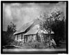 | July 5, 1973 (#73000376) | Mile 40 on the Haines Highway, near US-Canadian border 59°27′00″N 136°21′46″W / 59.45008°N 136.36282°W / 59.45008; -136.36282 (Pleasant Camp) | Haines | Also known as the Dalton Trail Camp, it was an outpost of the Canadian Northwest Mounted Police in the late 19th century. |
| 6 | Porcupine District |  | November 13, 1976 (#76000358) | 1 mile (1.6 km) southwest of Mile 35 of Haines Highway, across Klehini River 59°25′20″N 136°14′14″W / 59.4223°N 136.23714°W / 59.4223; -136.23714 (Porcupine District) | Haines | Mining camp mostly active in the early 20th century. |
See also
Wikimedia Commons has media related to National Register of Historic Places in Haines Borough, Alaska.
- List of National Historic Landmarks in Alaska
- National Register of Historic Places listings in Alaska
References
- ^ The latitude and longitude information provided in this table was derived originally from the National Register Information System, which has been found to be fairly accurate for about 99% of listings. Some locations in this table may have been corrected to current GPS standards.
- ^ National Park Service, United States Department of the Interior, "National Register of Historic Places: Weekly List Actions", retrieved March 22, 2024.
- ^ Numbers represent an alphabetical ordering by significant words. Various colorings, defined here, differentiate National Historic Landmarks and historic districts from other NRHP buildings, structures, sites or objects.
- ^ "National Register Information System". National Register of Historic Places. National Park Service. April 24, 2008.
- ^ The eight-digit number below each date is the number assigned to each location in the National Register Information System database, which can be viewed by clicking the number.
- v
- t
- e
- List of U.S. National Historic Landmarks by state:
- Alabama
- Alaska
- Arizona
- Arkansas
- California
- Colorado
- Connecticut
- Delaware
- Florida
- Georgia
- Hawaii
- Idaho
- Illinois
- Indiana
- Iowa
- Kansas
- Kentucky
- Louisiana
- Maine
- Maryland
- Massachusetts
- Michigan
- Minnesota
- Mississippi
- Missouri
- Montana
- Nebraska
- Nevada
- New Hampshire
- New Jersey
- New Mexico
- New York
- North Carolina
- North Dakota
- Ohio
- Oklahoma
- Oregon
- Pennsylvania
- Rhode Island
- South Carolina
- South Dakota
- Tennessee
- Texas
- Utah
- Vermont
- Virginia
- Washington
- West Virginia
- Wisconsin
- Wyoming
 National Register of Historic Places portal
 Category


| |||
|---|---|---|---|
Boroughs |  | ||
Census areas | |||
There are no sites listed on the National Register of Historic Places in Kusilvak Census Area. | |||
Municipalities and communities of Haines Borough, Alaska, United States | ||
|---|---|---|
Borough seat: Haines | ||
| CDPs | 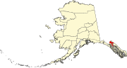 | |
| ||


