National Register of Historic Places listings in Matanuska-Susitna Borough, Alaska

This is a list of the National Register of Historic Places listings in Matanuska-Susitna Borough, Alaska.
This is intended to be a complete list of the properties and districts on the National Register of Historic Places in Matanuska-Susitna Borough, Alaska, United States. The locations of National Register properties and districts for which the latitude and longitude coordinates are included below, may be seen in an online map.[1]
There are 30 properties and districts listed on the National Register in the borough.
This National Park Service list is complete through NPS recent listings posted April 26, 2024.[2]
Map all coordinates using OpenStreetMap
Download coordinates as:
- KML
- GPX (all coordinates)
- GPX (primary coordinates)
- GPX (secondary coordinates)
Current listings
| [3] | Name on the Register[4] | Image | Date listed[5] | Location | City or town | Description |
|---|---|---|---|---|---|---|
| 1 | Bailey Colony Farm | 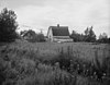 | June 21, 1991 (#91000775) | 3150 North Glenn Highway 61°36′57″N 149°07′10″W / 61.61585°N 149.11931°W / 61.61585; -149.11931 (Bailey Colony Farm) | Palmer | |
| 2 | Berry House | Upload image | June 21, 1991 (#91000779) | 5805 North Farm Loop Road 61°38′42″N 149°08′53″W / 61.64509°N 149.14801°W / 61.64509; -149.14801 (Berry House) | Palmer | |
| 3 | Campbell House |  | April 3, 2013 (#13000129) | 1540 Inner Springer Loop 61°34′15″N 149°07′38″W / 61.57094°N 149.1271°W / 61.57094; -149.1271 (Campbell House) | Palmer | |
| 4 | Cunningham-Hall PT-6, NC-692W | Upload image | December 29, 1978 (#78000531) | In Alaska Museum of Transportation and Industry, 3800 West Museum Drive 61°34′38″N 149°32′39″W / 61.57734°N 149.54426°W / 61.57734; -149.54426 (Cunningham-Hall PT-6, NC-692W) | Wasilla | Originally in the Transportation Museum of Alaska, in Palmer. |
| 5 | Curry Lookout | Upload image | April 27, 1992 (#92000424) | Atop Curry Ridge, mile 137.2 of the Parks Highway 62°37′22″N 150°05′54″W / 62.62264°N 150.09832°W / 62.62264; -150.09832 (Curry Lookout) | Talkeetna | |
| 6 | Fairview Inn |  | May 7, 1982 (#82004905) | Main Street 62°19′24″N 150°06′48″W / 62.32328°N 150.11332°W / 62.32328; -150.11332 (Fairview Inn) | Talkeetna | Also a contributing property to Talkeetna Historic District |
| 7 | Herried House | Upload image | June 21, 1991 (#91000778) | 4400 North Palmer-Fishook Road 61°37′41″N 149°10′13″W / 61.62793°N 149.17025°W / 61.62793; -149.17025 (Herried House) | Palmer | |
| 8 | High Ridge | Upload image | August 19, 2021 (#100006829) | 9721 East Hilscher Hwy. 61°34′39″N 149°10′26″W / 61.5775°N 149.1740°W / 61.5775; -149.1740 (High Ridge) | Palmer | Homesite of Fred Machetanz |
| 8 | Hyland Hotel |  | June 21, 1991 (#91000774) | 333 Evergreen Avenue 61°35′59″N 149°07′11″W / 61.5996°N 149.11974°W / 61.5996; -149.11974 (Hyland Hotel) | Palmer | |
| 9 | Independence Mines |  | October 9, 1974 (#74000440) | About 14.2 miles (22.9 km) northwest of Palmer 61°47′25″N 149°17′05″W / 61.7903°N 149.28467°W / 61.7903; -149.28467 (Independence Mines) | Palmer | |
| 10 | Kirsch's Place | Upload image | January 9, 1998 (#97001631) | About 10.5 miles (16.9 km) south of Talkeetna 62°10′01″N 150°04′30″W / 62.16704°N 150.07493°W / 62.16704; -150.07493 (Kirsch's Place) | Talkeetna | |
| 11 | Knik Site |  | July 24, 1973 (#73000379) | Along South Knik Goose Bay Road, about 13 miles (21 km) southwest of Wasilla 61°27′27″N 149°43′52″W / 61.45748°N 149.73108°W / 61.45748; -149.73108 (Knik Site) | Wasilla | |
| 12 | Matanuska Colony Community Center | Upload image | June 21, 1991 (#91000773) | Roughly bounded by South Colony Way, East Firewood Avenue, South Eklutna Street, East Elmwood Avenue, South Denali Street and a line of properties along East Dahlia Avenue 61°35′56″N 149°06′34″W / 61.59881°N 149.10944°W / 61.59881; -149.10944 (Matanuska Colony Community Center) | Palmer | |
| 13 | Old Willow Community Center | Upload image | October 5, 2017 (#100001695) | W. Willow Community Center Cir. 61°44′40″N 150°03′03″W / 61.744534°N 150.050840°W / 61.744534; -150.050840 (Old Willow Community Center) | Willow | |
| 14 | Palmer Depot | 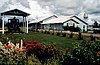 | January 9, 1978 (#78000530) | Corner of Evergreen Avenue and South Valley Way 61°36′00″N 149°06′49″W / 61.59999°N 149.11362°W / 61.59999; -149.11362 (Palmer Depot) | Palmer | Also a contributing property to Matanuska Colony Community Center |
| 15 | Patten Colony Farm | Upload image | June 21, 1991 (#91000776) | Mile 39.9 of the Glenn Highway, about 1.7 miles (2.7 km) southwest of Palmer 61°34′43″N 149°08′29″W / 61.57862°N 149.14138°W / 61.57862; -149.14138 (Patten Colony Farm) | Palmer | |
| 16 | Puhl House | 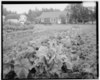 | June 21, 1991 (#91000777) | Corner of Scott Road and Glenn Highway 61°36′38″N 149°07′09″W / 61.61062°N 149.11908°W / 61.61062; -149.11908 (Puhl House) | Palmer | |
| 17 | Raymond Rebarchek Colony Farm | 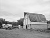 | October 3, 1978 (#78000532) | Along East Rebarcheck Avenue, about 1.6 miles (2.6 km) southwest of Palmer 61°34′38″N 149°07′37″W / 61.57728°N 149.1269°W / 61.57728; -149.1269 (Raymond Rebarchek Colony Farm) | Palmer | |
| 18 | Susitna River Bridge |  | September 15, 1977 (#77000227) | Alaska Railroad Mile 264.1, North of Gold Creek 62°46′05″N 149°41′35″W / 62.76793°N 149.69318°W / 62.76793; -149.69318 (Susitna River Bridge) | Gold Creek | Railroad bridge |
| 19 | Sutton Community Hall | Upload image | August 27, 2013 (#13000617) | Alon Jonesville Road, about 0.25 miles (0.40 km) north of Glenn Highway 61°42′40″N 148°53′49″W / 61.71118°N 148.89685°W / 61.71118; -148.89685 (Sutton Community Hall) | Sutton | |
| 20 | Talkeetna Airstrip |  | August 2, 2002 (#02000814) | Along D Street, from East First Street to the Susitna River 62°19′12″N 150°06′48″W / 62.31997°N 150.11333°W / 62.31997; -150.11333 (Talkeetna Airstrip) | Talkeetna | |
| 21 | Talkeetna Historic District |  | April 26, 1993 (#93000321) | Roughly bounded by C Street, East First Street, D Street, and Front Street 62°19′23″N 150°06′52″W / 62.32318°N 150.11437°W / 62.32318; -150.11437 (Talkeetna Historic District) | Talkeetna | Includes Fairview Inn |
| 22 | Tangle Lakes Archeological District | Upload image | November 12, 1971 (#71001091) | Address restricted[6] | Paxson | The archeological district is mostly comprised in Valdez–Cordova Census Area, Alaska.[7] |
| 23 | Teeland's Country Store |  | November 14, 1978 (#78000533) | Corner of East Herning Avenue and North Boundary Street 61°34′57″N 149°26′24″W / 61.58239°N 149.43991°W / 61.58239; -149.43991 (Teeland's Country Store) | Wasilla | |
| 24 | Blanche and Oscar Tryck House | Upload image | September 15, 2004 (#04000968) | North Knik Street, between Parks Highway and East Herning Avenue 61°34′53″N 149°26′38″W / 61.58133°N 149.44392°W / 61.58133; -149.44392 (Blanche and Oscar Tryck House) | Wasilla | |
| 25 | United Protestant Church | 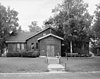 | April 10, 1980 (#80000757) | Corner of South Denali Street and East Elmwood Avenue 61°35′55″N 149°06′29″W / 61.59848°N 149.10793°W / 61.59848; -149.10793 (United Protestant Church) | Palmer | Also a contributing property to Matanuska Colony Community Center |
| 26 | Wasilla Community Hall | Upload image | September 8, 1982 (#82002072) | 323 Main Street 61°34′58″N 149°26′27″W / 61.58265°N 149.44095°W / 61.58265; -149.44095 (Wasilla Community Hall) | Wasilla | |
| 27 | Wasilla Depot |  | December 16, 1977 (#77000218) | 415 East Railroad Avenue 61°34′49″N 149°26′26″W / 61.58041°N 149.44054°W / 61.58041; -149.44054 (Wasilla Depot) | Wasilla | |
| 28 | Wasilla Elementary School |  | February 5, 1980 (#80000758) | Corner of East Swanson Avenue and North Boundary Street 61°34′58″N 149°26′24″W / 61.58288°N 149.4401°W / 61.58288; -149.4401 (Wasilla Elementary School) | Wasilla | |
| 29 | Whitney Section House | Upload image | October 6, 2004 (#04001106) | In Alaska Museum of Transportation and Industry, 3800 West Museum Drive 61°34′38″N 149°32′36″W / 61.57725°N 149.5433°W / 61.57725; -149.5433 (Whitney Section House) | Wasilla | Originally located in Anchorage, was moved to Palmer in 1976, and then to Wasilla in 1992.[8] |
See also
Wikimedia Commons has media related to National Register of Historic Places in Matanuska-Susitna Borough, Alaska.
- List of National Historic Landmarks in Alaska
- National Register of Historic Places listings in Alaska
References
- ^ The latitude and longitude information provided in this table was derived originally from the National Register Information System, which has been found to be fairly accurate for about 99% of listings. Some locations in this table may have been corrected to current GPS standards.
- ^ National Park Service, United States Department of the Interior, "National Register of Historic Places: Weekly List Actions", retrieved April 26, 2024.
- ^ Numbers represent an alphabetical ordering by significant words. Various colorings, defined here, differentiate National Historic Landmarks and historic districts from other NRHP buildings, structures, sites or objects.
- ^ "National Register Information System". National Register of Historic Places. National Park Service. April 24, 2008.
- ^ The eight-digit number below each date is the number assigned to each location in the National Register Information System database, which can be viewed by clicking the number.
- ^ Federal and state laws and practices restrict general public access to information regarding the specific location of this resource. In some cases, this is to protect archeological sites from vandalism, while in other cases it is restricted at the request of the owner. See: Knoerl, John; Miller, Diane; Shrimpton, Rebecca H. (1990), Guidelines for Restricting Information about Historic and Prehistoric Resources, National Register Bulletin, National Park Service, U.S. Department of the Interior, OCLC 20706997.
- ^ US Bureau of Land Management (2016). "Tangle Lakes Archaeological District trail brochure" (PDF). Retrieved May 30, 2017.
- ^ National Park Service. "Nomination form for Whitney Section House". Retrieved May 30, 2017. and accompanying photos
- v
- t
- e
- List of U.S. National Historic Landmarks by state:
- Alabama
- Alaska
- Arizona
- Arkansas
- California
- Colorado
- Connecticut
- Delaware
- Florida
- Georgia
- Hawaii
- Idaho
- Illinois
- Indiana
- Iowa
- Kansas
- Kentucky
- Louisiana
- Maine
- Maryland
- Massachusetts
- Michigan
- Minnesota
- Mississippi
- Missouri
- Montana
- Nebraska
- Nevada
- New Hampshire
- New Jersey
- New Mexico
- New York
- North Carolina
- North Dakota
- Ohio
- Oklahoma
- Oregon
- Pennsylvania
- Rhode Island
- South Carolina
- South Dakota
- Tennessee
- Texas
- Utah
- Vermont
- Virginia
- Washington
- West Virginia
- Wisconsin
- Wyoming
 National Register of Historic Places portal
 Category


| |||
|---|---|---|---|
Boroughs |  | ||
Census areas | |||
There are no sites listed on the National Register of Historic Places in Kusilvak Census Area. | |||
Municipalities and communities of Matanuska-Susitna Borough, Alaska, United States | ||
|---|---|---|
Borough seat: Palmer | ||
| Cities |  | |
| CDPs |
| |
| Former CDPs | ||
| Unincorporated communities |
| |
| ||


