National Register of Historic Places listings in Perry County, Alabama
This is a list of the National Register of Historic Places listings in Perry County, Alabama.
This is intended to be a complete list of the properties and districts on the National Register of Historic Places in Perry County, Alabama, United States. Latitude and longitude coordinates are provided for many National Register properties and districts; these locations may be seen together in a Google map.[1]
There are 19 properties and districts listed on the National Register in the county, including 1 National Historic Landmark.
This National Park Service list is complete through NPS recent listings posted April 26, 2024.[2]
Map all coordinates using OpenStreetMap
Download coordinates as:
- KML
- GPX (all coordinates)
- GPX (primary coordinates)
- GPX (secondary coordinates)
Current listings
| [3] | Name on the Register | Image | Date listed[4] | Location | City or town | Description |
|---|---|---|---|---|---|---|
| 1 | Bryand Brand House | Upload image | August 6, 2010 (#10000523) | Route 1, Box 260 32°40′26″N 87°23′46″W / 32.673889°N 87.396111°W / 32.673889; -87.396111 (Bryand Brand House) | Folsom vicinity | |
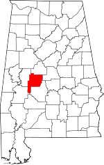
| 2 | Chapel and Lovelace Hall, Marion Military Institute | 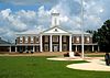 | September 13, 1978 (#78000508) | State Route 14 32°37′25″N 87°19′19″W / 32.62372°N 87.32199°W / 32.62372; -87.32199 (Chapel and Lovelace Hall, Marion Military Institute) | Marion | Buildings at Marion Military Institute |
| 3 | Fairhope Plantation |  | May 29, 1992 (#92000630) | U.S. Route 80 1 mile east of the Uniontown city limits 32°26′43″N 87°29′27″W / 32.44541°N 87.49093°W / 32.44541; -87.49093 (Fairhope Plantation) | Uniontown | |
| 4 | First Congregational Church of Marion |  | December 17, 1982 (#82001614) | 601 Clay St. 32°37′39″N 87°19′42″W / 32.6274°N 87.32847°W / 32.6274; -87.32847 (First Congregational Church of Marion) | Marion | |
| 5 | Green Street Historic District | 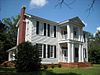 | May 30, 1979 (#79000400) | 203-751 W. Green St. 32°38′00″N 87°19′28″W / 32.6334°N 87.32447°W / 32.6334; -87.32447 (Green Street Historic District) | Marion | |
| 6 | Henry House | 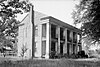 | September 25, 1986 (#86002744) | S. Washington St. 32°36′36″N 87°19′06″W / 32.61009°N 87.31841°W / 32.61009; -87.31841 (Henry House) | Marion | |
| 7 | Judson College Historic District |  | February 3, 1993 (#92001825) | Roughly bounded by E. Lafayette, Curb, Mason and Washington Sts. 32°37′49″N 87°18′52″W / 32.63024°N 87.31449°W / 32.63024; -87.31449 (Judson College Historic District) | Marion | |
| 8 | Kenworthy Hall |  | August 23, 1990 (#90001318) | State Route 14, west of Marion 32°38′07″N 87°21′08″W / 32.63516°N 87.35225°W / 32.63516; -87.35225 (Kenworthy Hall) | Marion | |
| 9 | Lincoln Normal School | Upload image | November 29, 2022 (#100001479) | 205 Lincoln St. 32°37′33″N 87°19′45″W / 32.6258°N 87.3292°W / 32.6258; -87.3292 (Lincoln Normal School) | Marion | |
| 10 | Marion Courthouse Square Historic District |  | February 16, 1996 (#96000111) | Roughly along Green, Washington, Jefferson, Jackson, Franklin, Clements, Centreville, and Monroe Sts. 32°37′58″N 87°19′07″W / 32.63291°N 87.31855°W / 32.63291; -87.31855 (Marion Courthouse Square Historic District) | Marion | |
| 11 | Moore-Webb-Holmes Plantation |  | August 24, 2011 (#11000566) | Junction of AL 14 & Webb Rd. 32°40′56″N 87°24′15″W / 32.68229°N 87.40425°W / 32.68229; -87.40425 (Moore-Webb-Holmes Plantation) | Marion vicinity | |
| 12 | Old Perry County High School | 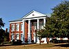 | October 4, 1973 (#73000372) | 202 W. Monroe St. 32°38′05″N 87°19′16″W / 32.63464°N 87.32122°W / 32.63464; -87.32122 (Old Perry County High School) | Marion | |
| 13 | Phillips Memorial Auditorium |  | February 13, 1990 (#88003243) | Lincoln Ave. and Lee St. 32°37′32″N 87°19′45″W / 32.62557°N 87.32918°W / 32.62557; -87.32918 (Phillips Memorial Auditorium) | Marion | Part of the Lincoln Normal School |
| 14 | Pitts' Folly |  | August 9, 1984 (#84000717) | Old Cahaba Rd. 32°26′42″N 87°30′30″W / 32.44507°N 87.50832°W / 32.44507; -87.50832 (Pitts' Folly) | Uniontown | |
| 15 | President's House, Marion Institute | 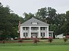 | May 14, 1979 (#79000401) | 110 Brown St. 32°37′30″N 87°19′13″W / 32.625101°N 87.320266°W / 32.625101; -87.320266 (President's House, Marion Institute) | Marion | President's house of Marion Military Institute |
| 16 | Siloam Baptist Church | 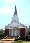 | December 27, 1982 (#82001615) | 503 Washington St. 32°37′51″N 87°19′10″W / 32.6308°N 87.31943°W / 32.6308; -87.31943 (Siloam Baptist Church) | Marion | |
| 17 | Uniontown Historic District |  | February 24, 2000 (#00000137) | Roughly bounded by Tomasene St., Taylor St., East Ave., and Green St. 32°27′10″N 87°30′52″W / 32.45282°N 87.51446°W / 32.45282; -87.51446 (Uniontown Historic District) | Uniontown | |
| 18 | West Marion Historic District | 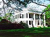 | April 22, 1993 (#92001844) | Roughly bounded by W. Lafayette St., Washington St., Murfree Ave., College St., and Margin St. 32°37′34″N 87°19′20″W / 32.626111°N 87.322222°W / 32.626111; -87.322222 (West Marion Historic District) | Marion | |
| 19 | Westwood |  | November 21, 1974 (#74000433) | North of Uniontown off State Route 61; also roughly bounded by U.S. Route 80, State Route 61, Rabbit Yard Rd., and the old Uniontown railroad spur 32°27′35″N 87°30′53″W / 32.45971°N 87.51462°W / 32.45971; -87.51462 (Westwood) | Uniontown | Second set of boundaries represents a boundary increase of December 10, 1984, the Westwood Plantation |
See also
Wikimedia Commons has media related to National Register of Historic Places in Perry County, Alabama.
- List of National Historic Landmarks in Alabama
- National Register of Historic Places listings in Alabama
References
- ^ The latitude and longitude information provided in this table was derived originally from the National Register Information System, which has been found to be fairly accurate for about 99% of listings. Some locations in this table may have been corrected to current GPS standards.
- ^ National Park Service, United States Department of the Interior, "National Register of Historic Places: Weekly List Actions", retrieved April 26, 2024.
- ^ Numbers represent an alphabetical ordering by significant words. Various colorings, defined here, differentiate National Historic Landmarks and historic districts from other NRHP buildings, structures, sites or objects.
- ^ The eight-digit number below each date is the number assigned to each location in the National Register Information System database, which can be viewed by clicking the number.
- v
- t
- e
- Fairhope Plantation
- Green Street Historic District
- Judson College Historic District
- Marion Courthouse Square Historic District
- Uniontown Historic District
- West Marion Historic District

properties
See also: National Register of Historic Places listings in Perry County, Alabama and List of National Historic Landmarks in Alabama
| ||
|---|---|---|
| Lists by county |
|  |
| Lists by city | ||
| Other lists | ||
Municipalities and communities of Perry County, Alabama, United States | ||
|---|---|---|
County seat: Marion | ||
| Cities |  | |
| Unincorporated communities | ||
| ||


