Newfoundland, Kentucky
Unincorporated community in Kentucky, United States
Unincorporated community in Kentucky, United States
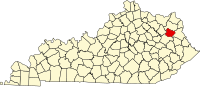
38°7′53″N 83°5′58″W / 38.13139°N 83.09944°W / 38.13139; -83.09944Newfoundland (also Crackers Neck) is an unincorporated community in Elliott County, Kentucky, United States. It lies along Routes 7 and 32 north of the city of Sandy Hook, the county seat of Elliott County.[1] Its elevation is 643 feet (196 m).[2]
References
- ^ Rand McNally. The Road Atlas '06. Chicago: Rand McNally, 2006, p. 43.
- ^ U.S. Geological Survey Geographic Names Information System: Newfoundland, Kentucky, Geographic Names Information System, 1979-09-20. Accessed 2008-01-03.
- v
- t
- e
Municipalities and communities of Elliott County, Kentucky, United States
County seat: Sandy Hook
communities
- Kentucky portal
- United States portal
 | This Elliott County, Kentucky state location article is a stub. You can help Wikipedia by expanding it. |
- v
- t
- e


