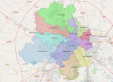
North East Delhi district
District of Delhi in India
North East Delhi | |
|---|---|
District of Delhi | |
| Country |  India India |
| State | Delhi |
| Division | Delhi Division |
| Headquarters | Nand Nagri |
| Government | |
| • Lok Sabha MP | Manoj Tiwari |
| • Deputy Commissioner | Mr Pankaj Kumar (IAS) |
| Area | |
| • District of Delhi | 62 km2 (24 sq mi) |
| Population (2011)[1] | |
| • District of Delhi | 2,241,624 |
| • Density | 36,155/km2 (93,640/sq mi) |
| • Urban | 2,220,097 |
| • Rural | 21,527 |
| Demographics | |
| • Population Growth | 26.78% |
| • Literacy | 83.09% |
| • Sex Ratio | 886 |
| Languages | |
| • Official | Hindi, Haryanvi |
| Time zone | UTC+5:30 (IST) |
| PIN | 1100xx[2] |
| Website | dmnortheast |
North East Delhi is one of the eleven administrative district of Delhi, India. The district was established in 1997. North East Delhi borders the Yamuna River on the west, Ghaziabad District to the north and east, East Delhi to the south, and North Delhi to the west across the Yamuna. Gokalpur,Karawal Nagar, Seelampur and Yamuna Vihar are 3 sub-divisions of this district.
Demographics
| Year | Pop. | ±% p.a. |
|---|---|---|
| 1961 | 38,155 | — |
| 1971 | 157,262 | +15.21% |
| 1981 | 487,466 | +11.98% |
| 1991 | 1,085,250 | +8.33% |
| 2001 | 1,768,061 | +5.00% |
| 2011 | 2,241,624 | +2.40% |
| source:[3] | ||
According to the 2011 census, North East Delhi had a population of 2,241,624, roughly equal to the nation of Latvia, or the United States state of New Mexico.[4][5] This gives it a ranking of 202nd in India (out of a total of 640).[4] The district has a population density of 36,155 inhabitants per square kilometre (93,640/sq mi) .[4] Its population growth rate over the decade 2001-2011 was 26.78%.[4] North East Delhi has a sex ratio of 886 females for every 1000 males,[4] and a literacy rate of 83.09%. The Scheduled Castes make up 16.67% of total district population.[4]
Religion
| Religion | Percent |
|---|---|
| Hinduism | 68.22 |
| Islam | 29.34 |
| Jainism | 1.1 |
| Sikhism | 0.78 |
| Christianity | 0.4 |
| Buddhism | 0.11 |
| Not stated | 0.05 |
Hindus are majority in the district consisting of 68.22% of total population, with a significant population of Muslims with 29.34%.
Assembly Constituencies
- Karawal Nagar
- Mustafabad
- Seelampur
- Gokalpur
- Burari
- Timarpur
- Ghonda
- Baburpur
Towns and villages
North East Delhi incorporates the following towns:[6]
- Yamuna Vihar
- Ghonda
- Brahmpuri
- Zafrabad
- Moujpur
- Babarpur
- Dayal Pur
- Karawal Nagar
- Gokal Pur
- Sonia Vihar
- Mandoli
- Saboli
- Nand Nagri
- Sunder Nagri
- Seemapuri
- Gautampuri
- Dilshad Garden
- Jiwan Pur (Johri Pur)
- Khajoori Khas
- Tukmeerpur
- Mustafabad
- Sadat Pur Gujran
- Brij Puri
- New Usmanpur
- Bhajanpura
- Ashok Nagar
- Harsh Vihar
- Shiv Vihar
Villages in North East Delhi are divided into three administrative villages: Shahdara with no sub-villages, Seema Purl with one sub village, Mandoli, and Seelam Pur with twelve sub-villages:[7]
- Badar Pur Khadar
- Pur Delhi
- Pur Shahdara
- Sabhapur Delhi
- Sabhapur Shahdara
- Baqiabad
- Sadat Pur
- Bihari Pur
- SHERPUR
- Garhi Mendu
- Tukhmir Pur
- Khan Pur Dhani
See also
References
- ^ "North East Delhi District : Census 2011 data". Census Organisation of India. 2011. Retrieved 31 December 2013.
- ^ North East Delhi
- ^ Decadal Variation In Population Since 1901
- ^ a b c d e f "District Census 2011". Census2011.co.in. 2011. Retrieved 30 September 2011.
- ^ US Directorate of Intelligence. "Country Comparison:Population". Archived from the original on 13 June 2007. Retrieved 1 October 2011.
Latvia 2,204,708 July 2011 est.
- ^ "2001 Census of India: List of Towns by District: Delhi" (PDF). Registrar General & Census Commissioner, India. p. 1.
- ^ "2001 Census of India: List of Villages by District and Tehsil: Delhi" (PDF). Registrar General & Census Commissioner, India. pp. 2–3.
External links
- North East Delhi official website
- East Delhi Information Portal
Places adjacent to North East Delhi district | ||||||||||||||||
|---|---|---|---|---|---|---|---|---|---|---|---|---|---|---|---|---|
| ||||||||||||||||


- v
- t
- e

- Timeline
- Indraprastha
- Hastinapur
- Tomaras
- Chauhan
- Prithviraj Raso
- Muslim conquests in the Indian subcontinent
- Delhi Sultanate
- Mamluk dynasty
- Khalji dynasty
- Tughlaq dynasty
- Sayyid dynasty
- Lodi dynasty
- Sher Shah Suri
- Mughal Empire
- Old Delhi
- Maratha Empire
- British East India Company
- Bahadur Shah Zafar
- Indian Rebellion of 1857
- British Raj
- Viceroy of India
- Indian independence movement
- Partition of India
- New Delhi
and administration
| Legislatures | |
|---|---|
| Heads | |
| Appellate courts | |
| GoI agencies | |
| GNCTD agencies | |
| Autonomous bodies |
and divisions
| Districts | |
|---|---|
| National Capital Region | |
| Satellite cities |
| Air |
| ||||
|---|---|---|---|---|---|
| Rail |
| ||||
| Road |
|
| Teams |
| ||||
|---|---|---|---|---|---|
| Stadiums |
| ||||
| Games |
- Independence Day
- Republic Day
- Cinema
- Shopping
- Delhi Pride
- Qutub Festival
- Punjabi cuisine
- Hindu temples
- Landmarks
- Museums
- Neighbourhoods
- Power plants
- Schools
- Universities and colleges
- Buildings and structures
- Neighbourhoods
- Tourist attractions
- Parks
- Notable people from Delhi
- List of cities in India by population
- India portal
28°41′37″N 77°18′26″E / 28.6936°N 77.3073°E / 28.6936; 77.3073


