Norwegian County Road 51
Road in Norway
 | |
|---|---|
| Bokmål: Fylkesvei 51 Nynorsk: Fylkesveg 51 | |
  Map of the road | |
| Route information | |
| Length | 168.2 km (104.5 mi) |
| Location | |
| Country | Norway |
| Highway system | |
| |
County Road 51 (Norwegian: Fylkesvei 51) is a 168.2-kilometer-long (104.5 mi) highway which runs north–south between Vågå and Gol, Norway. Part of the road runs concurrently with E16, between Leira and Fagernes. The 37-kilometer (23 mi) section across Valdresflye is designated a National Tourist Route.[1][2] This section is closed in the winter. Prior to 2010, the road was known as National Road 51 (Norwegian: Riksvei 51).
-
 Country road 51 running across Valdresflye
 -
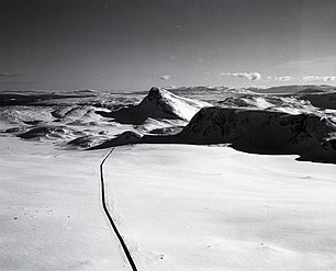
 The road with Bitihorn in the background


References
Wikimedia Commons has media related to Fylkesveg 51.
- v
- t
- e
National Tourist Routes
- Andøya
- 974
- 976
- 82
- Atlantic Ocean Road
- 64
- 242
- 663
- 235
- 238
- Aurlandsfjellet
- Gamle Strynefjellsvegen
- Gaularfjellet
- Geiranger–Trollstigen
- Hardanger
- Havøysund
- Helgeland Coast
- Jæren
- 44
- 507
- Lofoten
- Rondane
- Ryfylke
- 13
- 46
- 520
- Senja
- Sognefjellsvegen
- Valdresflye
- Varanger

 | This Norwegian road or road transport-related article is a stub. You can help Wikipedia by expanding it. |
- v
- t
- e


