| Pacifica State Beach | |
|---|---|
 | |
  | |
| Location | San Mateo County |
| Nearest city | Pacifica, California |
| Coordinates | 37°36′4″N 122°29′57″W / 37.60111°N 122.49917°W |
| Visitors | 1 million (annually) |
| Governing body | California Department of Parks and Recreation |
Pacifica State Beach is the southernmost of Pacifica, California's large beaches. It is a 0.75-mile-long (1.21 km) crescent-shaped beach located at the mouth of the San Pedro Valley in downtown Pacifica off State Route 1, in San Mateo County.[1] Over one million people visit this beach annually.[2]
Pacifica State Beach is one of the most popular beginner surfing spots in the San Francisco area. Among surfers it is commonly known as Linda Mar Beach because it fronts Pacifica's Linda Mar neighborhood. It is a State Beach managed by the City of Pacifica through an operating agreement with California State Parks. The Pacifica Skatepark is located directly across from the beach.
The beach is accessible via bus from Daly City station on SamTrans line 110.[3]
History
[edit]Between 1989 and 2005, Pacifica State Beach was the focus of an extensive beach habitat restoration program, in association with the San Pedro Creek flood control and habitat restoration. In 2002, as part of a partnership with the Pacifica Land Trust and the California Coastal Conservancy, this involved the $2.2 million purchase and removal of two oceanside homes and surrounding acreage for the purpose of beach and estuary restoration.[4]
This project was identified as a Top Restored Beach by the American Shore and Beach Preservation Association in 2005, cited as "...an example of a well-planned, well-executed coastal project that is the product of cooperative efforts of the local community, state and federal agencies, scientists, engineers and citizens. The complex beach and habitat restoration project involved over 10 regulatory and permitting agencies, funding from eight granting agencies and the active participation of eight environmental groups. It is one of the first beaches to utilize managed retreat as a method of shoreline protection. In addition to beach nourishment, it has restored habitat for four threatened and endangered species and enhanced community access with expanded parking lots, trails and new restrooms.
The World Dog Surfing Championships have been held at Pacifica State Beach since 2016.[5]
Wildlife
[edit]Pacifica State Beach provides habitat for the western snowy plover, a shorebird which is designated as threatened under the Endangered Species Act.[6][7]
Notable locations
[edit]Taco Bell Cantina
[edit]
The Taco Bell restaurant on the beach side of the highway is reputed to be the world's most scenic Taco Bell location.[8][9] The structure was built in the late 1960s and originally operated as an A&W Restaurant.[10] In 1972, California voters passed Proposition 20, which established the California Coastal Commission and barred buildings west of Highway 1; however, the Taco Bell was allowed to continue operations after being grandfathered in.[11] The Pacifica Taco Bell first gained national recognition in the 1990s, when Condé Nast Traveler listed it as one of the world's most scenic fast food restaurants.[11]
In 2019, the location underwent major renovations, including installing a fireplace and beginning to serve alcohol.[12][13] In 2020, the location went viral on TikTok after the travel influencer Megan Homme posted a video that gained several million views.[14][15]
A Los Angeles Times article addressing coastal erosion pointed out that the Taco Bell, which still boasts prime oceanfront views, could be seen as a sign that the climate-vulnerable Pacifica may be exceeding its intended lifespan.[16]
Gallery
[edit]-

-
 A skimboarder
 -
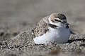 Snowy Plover
 -
 A trail behind and around Pacifica State Beach
.jpg)


References
[edit]- ^ Ostertag, George; Ostertag, Rhonda (2001). California State Parks : A Complete Recreation Guide. Seattle, WA: Mountaineers Books. p. 107. ISBN 0-89886-762-2.
- ^ "PWA - Project Detail - Pacifica State Beach Managed Retreat, Beach and Estuary Restoration". Retrieved January 23, 2010.
- ^ "Getting to Pacifica". Visit Pacifica. Retrieved September 8, 2023.
- ^ "NOAA Case Study: Pacifica State Beach Adopts Managed Retreat Strategy". coastalmanagement.noaa.gov. July 17, 2006. Archived from the original on October 4, 2006. Retrieved January 23, 2010.
- ^ Rachael Myrow, "Surfing Dogs Crush It at NorCal Championships in Pacifica", KQED, September 11, 2016.
- ^ "Western Snowy Plover Species Profile, Fish and Wildlife Service". Retrieved January 23, 2010.
- ^ "SF Chronicle: Help save endangered snowy plovers @ Pacifica State Beach in Linda Mar". Archived from the original on August 5, 2011. Retrieved January 23, 2010.
- ^ Jan Friedman (2005). Eccentric California (Bradt Travel Guide). Bradt Travel Guides. p. 95. ISBN 1-84162-126-9.
- ^ Bravo, Tony; Compton, Laura. "5 Northern California destinations that scream summer". Datebook. San Francisco Chronicle. Retrieved August 11, 2023.
- ^ Brinklow, Adam (July 10, 2019). "Architecturally stunning Pacifica Taco Bell remodeled". Curbed. Retrieved August 11, 2023.
- ^ a b Hartlaub, Peter. "Chalupa in paradise: Does Pacifica have the world's best Taco Bell?". San Francisco Chronicle. Archived from the original on December 14, 2022. Retrieved August 11, 2023.
- ^ Fort, Ellen (July 11, 2019). "World's Only Beachside Taco Bell Now Serves Booze". Eater. Retrieved August 11, 2023.
- ^ Hitchens, Antonia (April 17, 2023). "Taco Bell's Innovation Kitchen, the Front Line in the Stunt-Food Wars". The New Yorker. Retrieved August 11, 2023.
- ^ Callahan, Chrissy (November 12, 2020). "You have to see the 'nicest Taco Bell in the world' for yourself". USA Today. Retrieved August 11, 2023.
- ^ Schmidt, Ann W. (November 11, 2020). "Taco Bell's 'nicest' location stuns TikTok in viral video". Fox News. Archived from the original on October 27, 2022. Retrieved August 11, 2023.
- ^ Xia, Rosanna (July 7, 2019). "The California coast is disappearing under the rising sea. Our choices are grim". Los Angeles Times. Retrieved August 11, 2023.
External links
[edit]- California State Parks webpage
- 1990 General Plan
- California Coastal Records Project
- Pacifica State Beach Surf Reports
- San Pedro Creek Watershed Coalition
- Pacifica Shorebird Alliance
- City of Pacifica - Linda Mar Beach (Pacifica State Beach)
- Images of Linda Mar Beach, via UC Santa Cruz Digital Collections