Park Street, Sydney
Street in Sydney, Australia

Western end
Eastern end
- 33°52′23″S 151°12′25″E / 33.872969°S 151.207046°E / -33.872969; 151.207046 (Western end)
- 33°52′25″S 151°12′45″E / 33.873682°S 151.212594°E / -33.873682; 151.212594 (Eastern end)
Sydney CBD
- George Street
- Pitt Street
- Castlereagh Street
- Elizabeth Street
- College Street
Sydney CBD
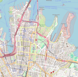
Park Street is a street in the central business district of Sydney in New South Wales, Australia. It runs from George Street in the west to College Street in the east, where it becomes William Street.[1]
Description

Park Street bisects Hyde Park,[a] hence its name. Publishing and Broadcasting Limited and its successor, Consolidated Media Holdings, had their corporate headquarters at 54 Park Street.[3]
An electric tramway once ran down Park Street between Elizabeth and College Streets. It was removed in 1960.
See also
 Australian Roads portal
Notes
- ^ Hyde park, the oldest in Australia, was created in 1810 by Governor Macquarie and has a state heritage listing.[2]
References
External links
KML file (edit • help)
Template:Attached KML/Park Street, Sydney
KML is from Wikidata
Wikimedia Commons has media related to Park Street, Sydney.
- Shirley Fitzgerald - City of Sydney History Unit (2008). "Poverty Point [corner of Park and Pitt Streets]". Dictionary of Sydney. Retrieved 28 September 2015. [CC-By-SA]
- v
- t
- e
Streets of Sydney, New South Wales, Australia
- Albion Street
- Alfred Street
- Bathurst Street
- Bridge Street
- Bayswater Road
- Broadway
- Castlereagh Street
- Chalmers Street
- City Road
- Clarence Street
- Cleveland Street
- College Street
- Crown Street
- Eddy Avenue
- Elizabeth Street
- George Street
- Glebe Point Road
- Goulburn Street
- Grosvenor Street
- Harris Street
- Hay Street
- Hunter Street
- Kent Street
- King Street
- Lime Street
- Liverpool Street
- Macquarie Street
- Market Street
- Martin Place
- Oxford Street
- Park Street
- Phillip Street
- Pitt Street
- Queen's Square
- Rowe Street
- Stanley Street
- Sussex Street
- Victoria Street
- Whitlam Square
- William Street
- York Street
- Anzac Parade
- Appian Way
- Bangor Bypass
- Barrenjoey Road
- Blacktown Road
- Bondi Road
- Burnt Bridge Creek Deviation
- City West Link
- Cumberland Highway
- Darling Street
- Epping Road
- General Holmes Drive
- Gore Hill Freeway
- Great North Road
- Great Western Highway
- Heathcote Road
- Henry Lawson Drive
- The Horsley Drive
- Hume Highway
- James Ruse Drive
- Jeffrey Street
- King Georges Road
- King Street
- Lane Cove Road
- New South Head Road
- Norton Street
- Old South Head Road
- Old Windsor Road
- Parramatta Road
- Pennant Hills Road
- Pittwater Road
- Princes Highway
- Prospect Highway
- Richmond Road
- Ryde Road
- Southern Cross Drive
- Syd Einfeld Drive
- Taren Point Road
- Victoria Road
- Windsor Road
- Wolseley Road
 | This Australian road or road transport-related article is a stub. You can help Wikipedia by expanding it. |
- v
- t
- e


