Pesterzsébet
20th District of Budapest Budapest XX. kerülete Pesterzsébet | |
|---|---|
| District XX | |
 Flag  Coat of arms | |
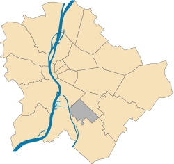
 Location of District XX in Budapest (shown in grey) | |
| Coordinates: 47°26′N 19°07′E / 47.433°N 19.117°E / 47.433; 19.117 | |
| Country | Hungary |
| Region | Central Hungary |
| City | Budapest |
| Established | 1 January 1950 |
| Quarters[1] | List
|
| Government | |
| • Mayor | Ákos Szabados (Ind.) |
| Area | |
| • Total | 12.19 km2 (4.71 sq mi) |
| • Rank | 17th |
| Population (2016)[2] | |
| • Total | 65,321 |
| • Rank | 14th |
| • Density | 5,358/km2 (13,880/sq mi) |
| Demonym | huszadik kerületi ("20th districter") |
| Time zone | UTC+1 (CET) |
| • Summer (DST) | UTC+2 (CEST) |
| Postal code | 1201 ... 1205 |
| Website | pesterzsebet |

Pesterzsébet is the 20th district of Budapest, Hungary. It is located in the southern part of the capital and is the 17th biggest district in the city. It is a mostly suburban area with approximately 70,000 residents.
History
Pesterzsébet was named until 1924 Erzsébetfalva, with a brief period of being called Leninváros during the Hungarian Soviet Republic, 1924–1932 Pesterzsébet, 1932–1950 Pestszenterzsébet, 1950–1990 Pesterzsébet.
-
 The Town Center and statue of Lajos Kossuth
 -
 A local and the main street behind
Sport
The most popular sport in this town is association football. The town had one team playing in the top level of the Hungarian football league system, the Nemzeti Bajnokság I. The name of the team was Erzsébeti TC, which played in the 1925–26 season.[3]
List of mayors
| Member | Party | Date | |
|---|---|---|---|
| Jenő Perlaki | Ind. | 1990–1998 | |
| Fidesz | |||
| Ákos Szabados | MSZP | 1998– | |
| Ind. | |||
Gallery
Twin towns
Pesterzsébet is twinned with:[4]
 Alushta, Ukraine
 Belin, Romania
 Cristuru Secuiesc, Romania
 Nowa Słupia, Poland
 Olgiate Comasco, Italy
 Nord-Ost (Frankfurt), Germany
See also
References
- ^ "94/2012. (XII. 27.) Főv. Kgy. rendelet - a közterület- és városrésznevek megállapításáról, azok jelöléséről, valamint a házszám-megállapítás szabályairól" (in Hungarian).
- ^ a b "A fővárosi kerületek, a megyei jogú városok, a városok területe, lakónépessége és a lakások száma" [The area of districts of the capital, of the towns with county's rights, resident population and number of dwellings]. Magyarország közigazgatási helynévkönyve 2016. január 1 [Gazetteer of Hungary 1 January 2016] (PDF). Hungarian Central Statistical Office. 2016. p. 21.
- ^ "Hungarian League 1925–26". Rec.Sport.Soccer Statistics Foundation.com. 29 May 2015.
- ^ "Pesterzsébet Testvérvárosai" (PDF) (in Hungarian). Pesterzsébet. Retrieved 18 October 2019.
External links
- Official homepage of Pesterzsébet
- Aerial photographs
- Picture gallery
- v
- t
- e
- I. Várkerület
- II. 2nd district
- III. Óbuda-Békásmegyer
- IV. Újpest
- V. Belváros-Lipótváros
- VI. Terézváros
- VII. Erzsébetváros
- VIII. Józsefváros
- IX. Ferencváros
- X. Kőbánya
- XI. Újbuda
- XII. Hegyvidék
- XIII. 13th district
- XIV. Zugló
- XV. 15th district
- XVI. 16th district
- XVII. Rákosmente
- XVIII. Pestszentlőrinc-Pestszentimre
- XIX. Kispest
- XX. Pesterzsébet
- XXI. Csepel
- XXII. Budafok-Tétény
- XXIII. Soroksár
traditions
- Budapest Business School
- Budapest University of Technology
- Corvinus University
- Eötvös Loránd University
- Hungarian University of Fine Arts
- Liszt Ferenc Academy of Music
- Moholy-Nagy University of Art and Design
- National University of Public Service
- Óbuda University
- Semmelweis University
- University of Physical Education
- Academy of Drama and Film
- Andrássy University
- Aquincum Institute of Technology
- Budapest Metropolitan University
- Budapest University of Jewish Studies
- Central European University
- International Business School
- Károli Gáspár University of Reformed Church
- Pázmány Péter Catholic University
 History of Budapest
 Category
  | This Hungarian history article is a stub. You can help Wikipedia by expanding it. |
- v
- t
- e
 | This Budapest location article is a stub. You can help Wikipedia by expanding it. |
- v
- t
- e


