Pottinger County
Map all coordinates using OpenStreetMap
Download coordinates as:
- KML
- GPX (all coordinates)
- GPX (primary coordinates)
- GPX (secondary coordinates)
Cadastral in New South Wales, Australia
| Pottinger New South Wales | |||||||||||||||
|---|---|---|---|---|---|---|---|---|---|---|---|---|---|---|---|
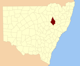 Location in New South Wales | |||||||||||||||
| |||||||||||||||
Pottinger County is one of the 141 cadastral divisions of New South Wales. It is located to the south west of the Namoi River and Mooki River, near Gunnedah.
Pottinger County was named in honour of the first Governor of Hong Kong Sir Henry Pottinger, first Baronet (1789-1856).[1]
Parishes
A full list of parishes found within this county; their current local government areas of Australia (LGA) and mapping coordinates to the approximate centre of each location is as follows:
| Parish | LGA | Coordinates |
|---|---|---|
| Baan Baa | Narrabri Shire | 30°36′54″S 150°01′04″E / 30.61500°S 150.01778°E / -30.61500; 150.01778 (Baan Baa Parish) |
| Bando | Gunnedah Shire | 31°08′54″S 150°00′04″E / 31.14833°S 150.00111°E / -31.14833; 150.00111 (Bando Parish) |
| Benelabri | Gunnedah Shire | 30°55′54″S 150°00′04″E / 30.93167°S 150.00111°E / -30.93167; 150.00111 (Benelabri Parish) |
| Bingle | Gunnedah Shire | 31°14′54″S 149°51′04″E / 31.24833°S 149.85111°E / -31.24833; 149.85111 (Bingle Parish) |
| Black Jack | Gunnedah Shire | 31°02′54″S 150°14′04″E / 31.04833°S 150.23444°E / -31.04833; 150.23444 (Black Jack Parish) |
| Boggabri | Narrabri Shire | 30°41′54″S 150°00′04″E / 30.69833°S 150.00111°E / -30.69833; 150.00111 (Boggabri Parish) |
| Bomera | Warrumbungle Shire | 31°28′54″S 149°51′04″E / 31.48167°S 149.85111°E / -31.48167; 149.85111 (Bomera Parish) |
| Breeza | Gunnedah Shire | 31°13′54″S 150°24′04″E / 31.23167°S 150.40111°E / -31.23167; 150.40111 (Breeza Parish) |
| Brennan | Warrumbungle Shire | 31°40′54″S 149°54′04″E / 31.68167°S 149.90111°E / -31.68167; 149.90111 (Brennan Parish) |
| Brigalow | Warrumbungle Shire | 30°59′54″S 149°45′04″E / 30.99833°S 149.75111°E / -30.99833; 149.75111 (Brigalow Parish) |
| Brothers | Gunnedah Shire | 31°14′54″S 150°11′04″E / 31.24833°S 150.18444°E / -31.24833; 150.18444 (Brothers Parish) |
| Brown | Gunnedah Shire | 31°11′54″S 150°12′04″E / 31.19833°S 150.20111°E / -31.19833; 150.20111 (Brown Parish) |
| Bulga | Warrumbungle Shire | 31°14′54″S 149°42′04″E / 31.24833°S 149.70111°E / -31.24833; 149.70111 (Bulga Parish) |
| Bundella | Liverpool Plains Shire | 31°38′54″S 149°57′04″E / 31.64833°S 149.95111°E / -31.64833; 149.95111 (Bundella Parish) |
| Calala | Gunnedah Shire | 31°14′54″S 150°03′04″E / 31.24833°S 150.05111°E / -31.24833; 150.05111 (Calala Parish) |
| Clarke | Warrumbungle Shire | 31°34′54″S 149°51′04″E / 31.58167°S 149.85111°E / -31.58167; 149.85111 (Clarke Parish) |
| Clift | Gunnedah Shire | 31°17′54″S 150°21′04″E / 31.29833°S 150.35111°E / -31.29833; 150.35111 (Clift Parish) |
| Coogal | Warrumbungle Shire | 31°00′54″S 149°52′04″E / 31.01500°S 149.86778°E / -31.01500; 149.86778 (Coogal Parish) |
| Coolanbilla | Liverpool Plains Shire | 31°24′54″S 150°08′04″E / 31.41500°S 150.13444°E / -31.41500; 150.13444 (Coolanbilla Parish) |
| Coomoo Coomoo | Liverpool Plains Shire | 31°39′54″S 150°08′04″E / 31.66500°S 150.13444°E / -31.66500; 150.13444 (Coomoo Coomoo Parish) |
| Curlewis | Gunnedah Shire | 31°08′54″S 151°20′04″E / 31.14833°S 151.33444°E / -31.14833; 151.33444 (Curlewis Parish) |
| Denison West | Narrabri Shire | 30°52′54″S 149°43′04″E / 30.88167°S 149.71778°E / -30.88167; 149.71778 (Denison West Parish) |
| Denison | Gunnedah Shire | 30°52′54″S 149°52′04″E / 30.88167°S 149.86778°E / -30.88167; 149.86778 (Denison Parish) |
| Digby | Gunnedah Shire | 31°07′54″S 150°12′04″E / 31.13167°S 150.20111°E / -31.13167; 150.20111 (Digby Parish) |
| Doona | Gunnedah Shire | 31°20′54″S 150°20′04″E / 31.34833°S 150.33444°E / -31.34833; 150.33444 (Doona Parish) |
| Dubbleda | Gunnedah Shire | 30°50′54″S 150°06′04″E / 30.84833°S 150.10111°E / -30.84833; 150.10111 (Dubbleda Parish) |
| Garrawilla | Warrumbungle Shire | 31°07′54″S 149°40′04″E / 31.13167°S 149.66778°E / -31.13167; 149.66778 (Garrawilla Parish) |
| Ghoolendaadi | Gunnedah Shire | 30°50′54″S 149°59′04″E / 30.84833°S 149.98444°E / -30.84833; 149.98444 (Ghoolendaadi Parish) |
| Gill | Gunnedah Shire | 31°01′54″S 150°08′04″E / 31.03167°S 150.13444°E / -31.03167; 150.13444 (Gill Parish) |
| Goally | Warrumbungle Shire | 31°06′54″S 149°49′04″E / 31.11500°S 149.81778°E / -31.11500; 149.81778 (Goally Parish) |
| Goragilla | Warrumbungle Shire | 31°16′54″S 149°40′04″E / 31.28167°S 149.66778°E / -31.28167; 149.66778 (Goragilla Parish) |
| Goran | Gunnedah Shire | 31°11′54″S 150°04′04″E / 31.19833°S 150.06778°E / -31.19833; 150.06778 (Goran Parish) |
| Gulligal | Narrabri Shire | 30°44′54″S 150°02′04″E / 30.74833°S 150.03444°E / -30.74833; 150.03444 (Gulligal Parish) |
| Gunnedah | Gunnedah Shire | 30°59′54″S 150°10′04″E / 30.99833°S 150.16778°E / -30.99833; 150.16778 (Gunnedah Parish) |
| Howes Hill | Liverpool Plains Shire | 31°14′54″S 150°08′04″E / 31.24833°S 150.13444°E / -31.24833; 150.13444 (Howes Hill Parish) |
| Johnston | Gunnedah Shire | 31°04′54″S 150°20′04″E / 31.08167°S 150.33444°E / -31.08167; 150.33444 (Johnston Parish) |
| Kickerbell | Liverpool Plains Shire | 31°29′54″S 150°21′04″E / 31.49833°S 150.35111°E / -31.49833; 150.35111 (Kickerbell Parish) |
| Lawson | Liverpool Plains Shire | 31°32′54″S 150°00′04″E / 31.54833°S 150.00111°E / -31.54833; 150.00111 (Lawson Parish) |
| Melville | Gunnedah Shire | 30°59′54″S 150°00′04″E / 30.99833°S 150.00111°E / -30.99833; 150.00111 (Melville Parish) |
| Mema | Liverpool Plains Shire | 31°29′54″S 150°05′04″E / 31.49833°S 150.08444°E / -31.49833; 150.08444 (Mema Parish) |
| Merrigula | Gunnedah Shire | 31°16′54″S 149°55′04″E / 31.28167°S 149.91778°E / -31.28167; 149.91778 (Merrigula Parish) |
| Millie | Gunnedah Shire | 30°57′54″S 150°04′04″E / 30.96500°S 150.06778°E / -30.96500; 150.06778 (Millie Parish) |
| Moredevil | Liverpool Plains Shire | 32°38′54″S 150°04′04″E / 32.64833°S 150.06778°E / -32.64833; 150.06778 (Moredevil Parish) |
| Mucca Mucca | Warrumbungle Shire | 31°15′54″S 149°36′04″E / 31.26500°S 149.60111°E / -31.26500; 149.60111 (Mucca Mucca Parish) |
| Nea | Gunnedah Shire | 31°13′54″S 150°17′04″E / 31.23167°S 150.28444°E / -31.23167; 150.28444 (Nea Parish) |
| Nombi | Warrumbungle Shire | 31°10′54″S 149°46′04″E / 31.18167°S 149.76778°E / -31.18167; 149.76778 (Nombi Parish) |
| Premer | Warrumbungle Shire | 31°25′54″S 149°55′04″E / 31.43167°S 149.91778°E / -31.43167; 149.91778 (Premer Parish) |
| Pringle | Liverpool Plains Shire | 31°32′54″S 150°04′04″E / 31.54833°S 150.06778°E / -31.54833; 150.06778 (Pringle Parish) |
| Rodd | Liverpool Plains Shire | 31°29′54″S 150°12′04″E / 31.49833°S 150.20111°E / -31.49833; 150.20111 (Rodd Parish) |
| Saltwater | Warrumbungle Shire | 31°27′54″S 149°47′04″E / 31.46500°S 149.78444°E / -31.46500; 149.78444 (Saltwater Parish) |
| Springfield | Liverpool Plains Shire | 31°25′54″S 150°14′04″E / 31.43167°S 150.23444°E / -31.43167; 150.23444 (Springfield Parish) |
| Tamarang | Liverpool Plains Shire | 31°20′54″S 149°57′04″E / 31.34833°S 149.95111°E / -31.34833; 149.95111 (Tamarang Parish) |
| Tambar | Warrumbungle Shire | 31°22′54″S 149°51′04″E / 31.38167°S 149.85111°E / -31.38167; 149.85111 (Tambar Parish) |
| Tinkrameanah | Warrumbungle Shire | 31°20′54″S 149°39′04″E / 31.34833°S 149.65111°E / -31.34833; 149.65111 (Tinkrameanah Parish) |
| Trinkey | Liverpool Plains Shire | 31°24′54″S 150°03′04″E / 31.41500°S 150.05111°E / -31.41500; 150.05111 (Trinkey Parish) |
| Tulla Mullen | Narrabri Shire | 30°37′54″S 149°55′04″E / 30.63167°S 149.91778°E / -30.63167; 149.91778 (Tulla Mullen Parish) |
| Urangera | Warrumbungle Shire | 31°16′54″S 149°47′04″E / 31.28167°S 149.78444°E / -31.28167; 149.78444 (Urangera Parish) |
| Walla Walla West | Narrabri Shire | 30°45′54″S 149°49′04″E / 30.76500°S 149.81778°E / -30.76500; 149.81778 (Walla Walla West Parish) |
| Walla Walla | Narrabri Shire | 30°45′54″S 149°55′04″E / 30.76500°S 149.91778°E / -30.76500; 149.91778 (Walla Walla Parish) |
| Weston | Liverpool Plains Shire | 31°26′54″S 150°23′04″E / 31.44833°S 150.38444°E / -31.44833; 150.38444 (Weston Parish) |
| Willala | Narrabri Shire | 30°41′54″S 149°54′04″E / 30.69833°S 149.90111°E / -30.69833; 149.90111 (Willala Parish) |
| Wilson | Warrumbungle Shire | 31°22′54″S 149°44′04″E / 31.38167°S 149.73444°E / -31.38167; 149.73444 (Wilson Parish) |
| Wondoba | Gunnedah Shire | 31°06′54″S 150°05′04″E / 31.11500°S 150.08444°E / -31.11500; 150.08444 (Wondoba Parish) |
| Yarraman | Liverpool Plains Shire | 31°37′54″S 150°12′04″E / 31.63167°S 150.20111°E / -31.63167; 150.20111 (Yarraman Parish) |
References
- ^ "Pottinger County". Geographical Names Register (GNR) of NSW. Geographical Names Board of New South Wales.


