Rossum, Overijssel
Village in Overijssel, Netherlands
52°21′8″N 6°55′23″E / 52.35222°N 6.92306°E / 52.35222; 6.92306 (2021)[2]
7596[2]
Rossum is a village in the Dutch province of Overijssel. It is a part of the municipality of Dinkelland, and lies about 4 km north of Oldenzaal on the road to Ootmarsum.
It was first mentioned in the late-10th century as Rohthem, and means "settlement near cleared forest".[4] In 1840, it was home to 504 people.[5]
The Hunenborg is a circular rampart to the north of Rossum. In 1916, remnants of wooden buildings were discovered at the site. Later a wooden dam dating from the 1150s was uncovered, and may be the location of a 10th century fortress of the Prince-Bishop of Utrecht.[6]
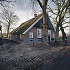
In the rural environment some farms can be found in the traditional building style of the timber framed Low German house.
Notable people
- Patrick Bosch (1964–2012), football player[7]
Gallery
-
 St. Plechelmus church
 -
-
 Agriculture in Rossum


References
- ^ Dialexicon Twents
- ^ a b c "Kerncijfers wijken en buurten 2021". Central Bureau of Statistics. Retrieved 15 March 2022.
- ^ "Postcodetool for 7596JA". Actueel Hoogtebestand Nederland (in Dutch). Het Waterschapshuis. Retrieved 15 March 2022.
- ^ "Rossum - (geografische naam)". Etymologiebank (in Dutch). Retrieved 15 March 2022.
- ^ "Rossum". Plaatsengids (in Dutch). Retrieved 15 March 2022.
- ^ Ronald Stenvert & Jan ten Hove (1998). "Rossum" (in Dutch). Zwolle: Waanders. p. 247. ISBN 90 400 9200 1. Retrieved 15 March 2022.
- ^ "Patrick Bosch". FC Twente Statistieken (in Dutch). Retrieved 15 March 2022.
 | This Overijssel location article is a stub. You can help Wikipedia by expanding it. |
- v
- t
- e


