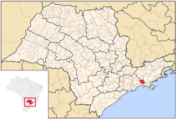
Salesópolis | |
|---|---|
| Municipality of Salesópolis | |
 Location of Salesópolis | |
| Coordinates: 23°50′46″S 46°37′47″W / 23.84611°S 46.62972°W | |
| Country | |
| Region | Southeast |
| State | |
| Government | |
| • Mayor | Vanderlon Oliveira Gomes (PL) |
| Area | |
• Total | 424.997 km2 (164.092 sq mi) |
| Elevation | 850 m (2,790 ft) |
| Population (2020)[1] | |
• Total | 17,252 |
| • Density | 41/km2 (110/sq mi) |
| Time zone | UTC−3 (BRT) |
| HDI (2010) | 0.732 – high[2] |
| Website | www |
Salesópolis is a municipality in the state of São Paulo in Brazil. It is part of the Metropolitan Region of São Paulo.[3] The population is 17,252 (2020 est.) in an area of 424.997 km².[4] Salesópolis sits at an elevation of 850 metres (2,790 ft). It is noted for being the source of the Tietê River.[5]
Salesópolis was founded in the 19th century as São José do Paraitinga, and later became the parish of Santana de Mogi das Cruzes in 1838. The parish was elevated to municipality status on March 24, 1857, but renamed Salesópolis in 1905 after a visit of the president of Brazil, Campos Sales (1841-1913).[5]
The Tietê River flows in the northern part of the municipality, and much of the southern part of the municipality is mountainous, heavily forested, and inaccessible. The Atlantic Forest (Mata Atlântica) of Salesópolis were largely destroyed in the late 19th and early 20th century, but 96 ha of the municipality are now protected as part of the Boracéia Biological Station, a unit of the Museum of Zoology of the University of São Paulo established in 1954. Salesópolis is home to the Buchenavia rabelloana, a species of plant in the Combretaceae family. The species is listed as endangered on the IUCN Red List of Threatened Species.[6][7]
Population history
[edit]| Year | Population |
|---|---|
| 2003 | 15,283 |
| 2004 | 15,294 |
| 2015 | 16,688 |
Media
[edit]In telecommunications, the city was served by Companhia de Telecomunicações do Estado de São Paulo until 1975, when it began to be served by Telecomunicações de São Paulo.[8] In July 1998, this company was acquired by Telefónica, which adopted the Vivo brand in 2012.[9]
The company is currently an operator of cell phones, fixed lines, internet (fiber optics/4G) and television (satellite and cable).[9]
See also
[edit]References
[edit]- ^ IBGE 2020
- ^ "Archived copy" (PDF). United Nations Development Programme (UNDP). Archived from the original (PDF) on July 8, 2014. Retrieved August 1, 2013.
{{cite web}}: CS1 maint: archived copy as title (link) - ^ Lei Complementar nº 1.139, de 16 de junho de 2011
- ^ Instituto Brasileiro de Geografia e Estatística
- ^ a b "Salesópolis" (in Portuguese). Brasília, Brazil: Instituto Brasileiro de Geografia e Estatística. 2015. Retrieved 2016-11-18.
- ^ Silva, N.M.F. (1998). "Buchenavia rabelloana". Brasília, Brazil: IUCN Red List of Threatened Species. Retrieved 2016-11-18.
- ^ "Estação Biológica de Boracéia" (in Portuguese). São Paulo, Brazil: Museu de Zoologia da Universidade de São Paulo. 2010. Retrieved 2015-07-01.
- ^ "Creation of Telesp - April 12, 1973". www.imprensaoficial.com.br (in Portuguese). Retrieved 2024-05-26.
- ^ a b "Our History - Telefônica RI". Telefônica. Retrieved 2024-05-26.
External links
[edit]- (in Portuguese) Official website
- (in Portuguese) citybrazil.com.br Archived 2008-02-23 at the Wayback Machine


