Shevchenkivskyi District, Zaporizhzhia
City district of Zaporizhzhia, Ukraine
Urban district in Zaporizhzhia Municipality, Ukraine
Shevchenkivskyi District Шевченківський район | |
|---|---|
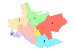 Administrative map of Zaporizhzhia; the Shevchenkivskyi District is indicated by the number 7. | |
| 47°50′56″N 35°15′13″E / 47.84889°N 35.25361°E / 47.84889; 35.25361 | |
| Country |  Ukraine Ukraine |
| Municipality | Zaporizhzhia Municipality |
| Established | 30 December 1962 |
| Area | |
| • Total | 98.0 km2 (37.8 sq mi) |
| Population (2001) | |
| • Total | 157,000 |
| • Density | 1,600/km2 (4,100/sq mi) |
| Time zone | UTC+2 (EET) |
| • Summer (DST) | UTC+3 (EEST) |
The Shevchenkivskyi District (Ukrainian: Шевченківський район, Shevchenkivsʹkyi raion) is one of seven administrative urban districts (raions) of the city of Zaporizhzhia, located in southern Ukraine.[1][2] Its population was 157,000 in the 2001 Ukrainian Census.[3]
Geography
The largest of Zaporizhzhia's seven urban districts, the district has an area of 98.0 square kilometres (37.8 sq mi), making up approximately 29.3% of the total administrative area of Zaporizhzhia. The district is located fully on the left (east) side of the Dnieper river.[2]
History
The district was founded in 1962 by separating it from Zhovtnevyi District[2] (since 2016 Oleksandrivskyi District). Following the passage of decommunization laws, in 2016, numerous streets within the district were renamed to replace their Soviet-era names. Some of the new street names include Sikorskyi St., Mykola Kytsenko St., Leonid Prynia St., Maksym Kryvonos St., Bohdan Zavada St., Malv St., and Vasyl Didenko St..[4]
Neighborhoods
- 1st Shevchenkivskyi mikrorayon
- 2nd Shevchenkivskyi mikrorayon
- 3rd Shevchenkivskyi mikrorayon
- Budivelnyk
- Viyskbud
- DD
- Dymytrova
- Zelenyi Yar
- Kalantyrivka
- Levanevskoho
- Teplychne, Zaporizhzhia
Gallery
-
 The district in the winter
 -
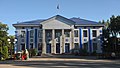 Bohuslayev's Technics Museum
 -
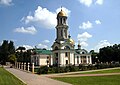 Saint Andrew's Cathedral (Russian Orthodox Church)


References
- ^ "Number of the population of the City of Zaporizhzhia" (PDF) (in Ukrainian). State Statistics Service of Ukraine in Zaporizhzhia Oblast. 20 June 2012. Retrieved 25 January 2015.
- ^ a b c "City Districts - Zaporizhzhia City Council". zp.gov.ua. Retrieved 16 September 2023.
- ^ "About number and composition population of Zaporizhzhia Region by data All-Ukrainian census of the population 2001". 2001.ukrcensus.gov.ua. Retrieved 16 September 2023.
- ^ Herasin, Volodymyr. "Запоріжжя позбавляється пам'ятників і назв комуністичної доби". Запорозька Січ (in Ukrainian). Retrieved 17 September 2023.
- v
- t
- e
- Khortytskyi
- Komunarskyi
- Dniprovskyi
- Voznesenskyi
- Shevchenkivskyi
- Zavodskyi
- Oleksandrivskyi

 | This article about a location in Zaporizhzhia Oblast is a stub. You can help Wikipedia by expanding it. |
- v
- t
- e


