Shimokita Hantō Quasi-National Park
41°31′33″N 140°55′25″E / 41.52583°N 140.92361°E / 41.52583; 140.92361Area 18,728 hectares (72.31 sq mi) Established July 22, 1968 Governing body Aomori, prefectural governments [1] National Parks 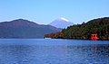
Quasi-National Parks
Shimokita Hantō Quasi-National Park (下北半島国定公園, Shimokita-hantō Kokutei Kōen) is a quasi-national park in the Shimokita Peninsula of Aomori Prefecture in the Tōhoku region of far northern Honshū in Japan. It is rated a protected landscape (category V) according to the IUCN.[2] The park, consists of several discontinuous locations, which include:
- the volcanic peaks and caldera lakes of the Osorezan Mountain Range and surrounding forests.
- Yagen Valley, with its hot springs
- the coastal rock formations of Hotokegaura on the west coast of Shimokita Peninsula
- Cape Ōma, the northernmost point of Honshū
- Cape Shiriya, the northeasternmost point Honshū and the Sarugamori Sand Dunes
- Taijima, an island off the coast of Wakinosawa
The park also encompasses a portion of the natural habitat of the Japanese macaque. The mountainous interior is forested with Siebold's beech and Nootka cypress, and coastal areas have stands of tilia and oak.[3] The area was designated a quasi-national park on July 22, 1968.
The borders of the park span the municipalities of Mutsu, Higashidōri, Sai, and Ōma.[4]
Like all Quasi-National Parks in Japan, Shimokita Hantō Quasi-National Park is managed by the local prefectural government.[1]
Gallery


See also
References
- Southerland, Mary and Britton, Dorothy. The National Parks of Japan. Kodansha International (1995). ISBN 4-7700-1971-8
- ^ a b "National Park systems: Definition of National Parks". National Parks of Japan. Ministry of the Environment of the Government of Japan. Archived from the original on 2011-03-23. Retrieved 2008-08-29.
- ^ "Shimokita Hanto". World Database on Protected Areas. United Nations Environment Programme, World Conservation Monitoring Center. Retrieved 2009-10-05.
- ^ "List of Quasi-national Parks". Official Home Page of the Ministry of the Environment. Ministry of the Environment Government of Japan. 1994-03-31. Retrieved 2009-10-05.
- ^ 下北半島国定公園 [Shimokita Hantō Quasi-National Park] (in Japanese). Aomori Prefecture. Retrieved 23 August 2012.
External links
 Media related to Shimokitahanto Quasi-National Park at Wikimedia Commons
- Maps of Shimokita Hantō Quasi-National Park
- v
- t
- e
- Akan
- Amami Guntō
- Ashizuri-Uwakai
- Aso-Kujū
- Bandai-Asahi
- Chichibu-Tama-Kai
- Chūbu-Sangaku
- Daisen-Oki
- Daisetsuzan
- Fuji-Hakone-Izu
- Hakusan
- Hidakasanmyaku-Erimo-Tokachi
- Iriomote-Ishigaki
- Ise-Shima
- Jōshinetsu Kōgen
- Kerama Shotō
- Kirishima-Kinkowan
- Kushiro Shitsugen
- Minami Alps
- Myōkō-Togakushi Renzan
- Nikkō
- Ogasawara
- Oze
- Rishiri-Rebun-Sarobetsu
- Saikai
- Sanin Kaigan
- Sanriku Fukkō
- Setonaikai
- Shikotsu-Tōya
- Shiretoko
- Towada-Hachimantai
- Unzen-Amakusa
- Yambaru
- Yakushima
- Yoshino-Kumano

- Abashiri
- Aichi Kōgen
- Akiyoshidai
- Biwako
- Chōkai
- Echigo Sanzan-Tadami
- Echizen-Kaga Kaigan
- Genkai
- Hayachine
- Hiba-Dōgo-Taishaku
- Hida-Kisogawa
- Hyōnosen-Ushiroyama-Nagisan
- Ibi-Sekigahara-Yōrō
- Iki-Tsushima
- Ishizuchi
- Kita Nagato
- Kitakyūshū
- Kongō-Ikoma-Kisen
- Kōya-Ryūjin
- Kurikoma
- Kyoto Tamba Kōgen
- Kyūshū Chūō Sanchi
- Meiji no Mori Minō
- Meiji no Mori Takao
- Mikawa Wan
- Minami Bōsō
- Minami Sanriku Kinkasan
- Murō-Akame-Aoyama
- Muroto-Anan Kaigan
- Myōgi-Arafune-Saku Kōgen
- Nichinan Kaigan
- Nippō Kaigan
- Niseko-Shakotan-Otaru Kaigan
- Nishi-Chūgoku Sanchi
- Noto Hantō
- Oga
- Okinawa Kaigan
- Okinawa Senseki
- Ōnuma
- Sado-Yahiko-Yoneyama
- Shimokita Hantō
- Shokanbetsu-Teuri-Yagishiri
- Sobo Katamuki
- Suigō-Tsukuba
- Suzuka
- Tango-Amanohashidate-Ōeyama
- Tanzawa-Ōyama
- Tenryū-Okumikawa
- Tsugaru
- Tsurugisan
- Wakasa Wan
- Yaba-Hita-Hikosan
- Yamato-Aogaki
- Yatsugatake-Chūshin Kōgen
- Zaō
 | This Aomori Prefecture location article is a stub. You can help Wikipedia by expanding it. |
- v
- t
- e
 | This article about a national/quasi-national park or protected area in Japan, or related topic is a stub. You can help Wikipedia by expanding it. |
- v
- t
- e


