| Thorpe Edge | |
|---|---|
 York House | |
 Thorpe Edge Location within West Yorkshire | |
| Metropolitan borough | |
| Metropolitan county | |
| Region | |
| Country | England |
| Sovereign state | United Kingdom |
| Post town | BRADFORD |
| Postcode district | BD10 |
| Dialling code | 01274 |
| Police | West Yorkshire |
| Fire | West Yorkshire |
| Ambulance | Yorkshire |
Thorpe Edge is a housing estate located in Bradford, West Yorkshire, England. The estate is situated off Harrogate Road in the north-east of the city, and borders Idle, Five Lane Ends, Greengates and Eccleshill.
History
[edit].jpg)
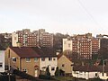
Once farm land, the estate was mostly constructed in the 1950s. It was constructed mostly of low-rise housing but, with two high-rise developments; the York Place flats and the Fairhaven Green flats. All of the high-rise flats are eight-storeys in height and still standing,[1] the larger York House had shops on the ground floor. Some mid-rise flats were also constructed along the Northern edge of the estate. These were demolished in the 2010s. Some of the older low-rise houses were demolished in the 2000's. York House recently underwent a site survey and deemed unfit for purpose. Incommunities filed an application to Bradford Council for the demolition of the site, and the council agreed. Work started in the summer of 2024. Now completed in early 2025, The grounds that York House once stood, is awaiting the construction of social housing.
-
 Fairhaven flats
 -
 Retail shops, York House
 -
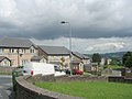 Newer 1990s built houses which replaced older low-rise housing
 -
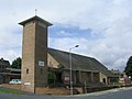 St John the Divine Church
.jpg)
.jpg)


Amenities
[edit]The estate has a church; St John the Divine on Idlethorp Way, a school; Parkland Primary School. Since the demolition of York House, they are currently no shops on the estate. Thorpe Edge is surrounded by areas with a greater number of amenities such as, Enterprise Five retail park situated at Five Lane Ends. Sainsbury's supermarket and Matalan retail store is also nearby at Greengates, whilst Eccleshill swimming baths is situated at Eccleshill. Apperley Bridge railway station is approximately 1 mile away.
Notable Citizens
[edit]Notable citizens include:
● Rapper and musical artist Mark "Marky B" Baldwin.
● Philanthropist and Entrepreneur Jim Bradford.
References
[edit]- ^ "Tower Block - Thorp Edge". University of Edinburgh. Retrieved 14 May 2020.