Vale, Guernsey
Parish

Flag
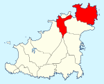
Location of Vale in Guernsey
(2019)
Vale (Guernésiais: Lé Vale; French: Le Valle) is one of the ten parishes of Guernsey in the Bailiwick of Guernsey, Channel Islands.
In 933 the islands, formerly under the control of William I, then Duchy of Brittany were annexed by the Duchy of Normandy. The island of Guernsey and the other Channel Islands represent the last remnants of the medieval Duchy of Normandy.[1]
Much of the Vale parish belonging to the fief Saint Michael, which benefited the Benedictine monks who lived in an abbey that had been built next to the Vale Church from when it was granted in 1032 by Robert of Normandy who had apparently been caught in a storm and his ship had ended up safe in Guernsey. The rights to the fief were removed by Henry VIII when he undertook the Dissolution of the Monasteries.[2]: 128–9
Vale Castle
The Castle of Saint Michael, now called Vale Castle, has an origin going back at least 1,000 years and was used as a refuge from pirate attacks. It was probably started in the late 10th century.[2]: 130–1 In 1372 Owain Lawgoch, a claimant to the Welsh throne, attacked Guernsey at the head of a free company, on behalf of France. This event is popularly called La Descente des Aragousais. Owain Lawgoch withdrew after killing 400 of the Island militia.[3] The poem of the same name refers to the castle as the Château de l'Archange, the location of the last-ditch stand against the insurgents.[4]: 34
In 1615 the island[which?] was required to maintain the Vale Castle, while the Crown maintained Castle Cornet.[4]: 31 It has been a focal point for defence; the most recent modifications were undertaken by the German occupiers.
Modern era
Until 1806 the parish occupied territory on the mainland of Guernsey, the Vingtaine de l'Epine, as well as the whole of Le Clos du Valle, a tidal island forming the northern extremity of Guernsey separated from the mainland by Le Braye du Valle, a tidal channel. Le Braye was drained and reclaimed in 1806 by the British Government as a defence measure. Vale now consists of two non-contiguous territories.
The Vale postal code mainly starts with GY3 with some starting GY8.
Features
| The features of the parish include:
| The parish of the Vale hosts:
 
|
Other
The parish was twinned with the Normandy port of  Barneville-Carteret in 1987.
Politics
Vale comprises the whole of the Vale administrative division
In the 2016 Guernsey general election there was a 3,774 or 74% turnout to elect six Deputies. Those elected (in order of votes received) being Matt Fallaize, Dave Jones, Mary Lowe, Laurie Queripel, Jeremy Smithies and Sarah Hansmann Rouxel.
Dave Jones died in July 2016 and a by-election was held in October 2016 to elect a replacement.
References
- ^ Marr, J., The History of Guernsey – the Bailiwick's story, Guernsey Press (2001).
- ^ a b Berry, William. The history of Guernsey from the remotest period of antiquity to the year 1814.
- ^ The Guernsey and Jersey Magazine, Volumes 1-2. 1836. p. 169.
- ^ a b Marr, James. Bailiwick Bastions. Guernsey Press. ISBN 0 902550 11 X.
- ^ a b c d e Dillon, Paddy. Channel Island Walks. Cicerone Press Limited, 1999. ISBN 9781852842888.
- ^ "Vale Mission Fellowship".
- ^ "St Pauls Mission Methodist Church".
- ^ a b "Vale Parish Memorial, Guernsey". Great War CI.
- ^ "Doomsday Reloaded D-block CI-534000-5479000". BBC.
- ^ "Vale Pond". La Société Guernesiaise.
- ^ "History of the Vale Castle". BBC.
- ^ "Rousse Tower". BBC.
- ^ "Dehus Dolmen – Guernsey's Most Impressive Passage Grave". megalithicguernsey.
- ^ "La Platte Mare". megalithicguernsey.
- ^ a b "L'Ancresse/Pembroke Bays". Visit Guernsey.
- ^ "Channel Islands Marine Conservation Society Recommended beaches". thebeachguide.co.uk. Retrieved 24 May 2017.
- ^ "Bordeaux Harbour". Visit Guernsey.
- ^ "PROTECTED BUILDINGS". Environment - Guernsey government.
- v
- t
- e
Bailiwick of Guernsey articles | ||||||
|---|---|---|---|---|---|---|
| History |
|  | ||||
| Geography |
| |||||
| Education |
| |||||
| Politics | ||||||
| Economy |
| |||||
| Culture |
| |||||
| ||||||
49°29′34″N 2°31′22″W / 49.49278°N 2.52278°W / 49.49278; -2.52278


