Saint Andrew, Guernsey
Parish

Flag

Location of St. Andrew in Guernsey
(2019)
Saint Andrew (Guernésiais: Saint Andri; French: Saint-André-de-la-Pommeraye) is located in the centre of Guernsey and as such is the only parish on the island to be landlocked.
As it is customary to list the parishes round the coast, either clockwise or anti-clockwise, starting with St Peter Port, St Andrew is usually the last parish to be mentioned in such a list. This gave rise to the traditional nickname in Dgèrnésiais of the inhabitants of the parish: les croinchaons (the siftings, what is left behind in the sieve).
General
Saint Andrew is located in the centre of the island and features hills and valleys. It is split into two parts, one bordering St Peter Port and one bordering St Saviour and the Forest. The upper part of the parish where the church and the Little Chapel is situated is very rural. The parish is mainly agricultural, Best's quarry now being used for water storage. St Andrews is the most expensive parish for buying property in Guernsey, closely followed by St Pierre Du Bois and St Saviour. The postal code for street addresses in this parish begins with GY6.
Features
| The features of the parish include:
| The parish of Saint Andrew hosts:
|
Politics
St Andrew comprises part of the South East administrative division with St Martin.
In the 2016 Guernsey general election there was a 3,363 or 73% turnout to elect five Deputies. Those elected (in order of votes received) being Heidi Soulsby, Lindsay De Sausmarez, Peter Roffey, Rob Prow and Victoria Oliver.
Gallery
-
 Little Chapel, Guernsey
 -
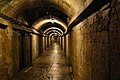 German underground hospital


References
Wikimedia Commons has media related to Saint Andrew's, Guernsey.
- ^ "St. Andrews Church, Guernsey".
- ^ "The Monnaie Chapel, Guernsey".
- ^ "La Villiaze Church, Guernsey".
- ^ Kelly, Fergus (29 September 2012). "Warm to a taste of the Gallic in Guernsey". Express. Retrieved 30 June 2013.
- ^ "Guernsey Destination Guide". Premier Holidays. Retrieved 30 June 2013.
- ^ "St Andrew's Parish Memorial, Guernsey". Great War CI.
- ^ "German Military Underground Hospital". BBC.
- ^ "Guernsey Abreuvoirs". La Société Guernesiaise.
- ^ "PROTECTED BUILDINGS". Environment - Guernsey government.
- ^ "Les Bourges Hospice".
External links
- The Little Chapel of Guernsey
- v
- t
- e
Bailiwick of Guernsey articles | ||||||
|---|---|---|---|---|---|---|
| History |
|  | ||||
| Geography |
| |||||
| Education |
| |||||
| Politics | ||||||
| Economy |
| |||||
| Culture |
| |||||
| ||||||


