Chhusang
| gaun wikas samiti | |||
 | |||
| Państwo |
| ||
|---|---|---|---|
| Strefa | Dhawalagiri | ||
| Dystrykt | Mustang | ||
| Populacja (2001) • liczba ludności |
| ||
Położenie na mapie Nepalu  | |||
 28°59′N 83°49′E/28,983333 83,816667 28°59′N 83°49′E/28,983333 83,816667 | |||
| |||


Chhusang – gaun wikas samiti w zachodniej części Nepalu w strefie Dhawalagiri w dystrykcie Mustang[1]. Według nepalskiego spisu powszechnego z 2001 roku liczył on 186 gospodarstw domowych i 668 mieszkańców (336 kobiet i 332 mężczyzn)[2].
- VDC Chhusang
-
 Chhusang
 -
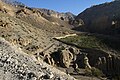
 Droga Chhusang - Chele
 -
 Chele
Chele -
 Droga Chele - Samar
 -
 Samar
Samar -
 Ghyakar
 -
 Thangbe


