Pembrokeshire
| hrabstwo | |||||
 | |||||
| Dewiza: Ex Unitate Vires (łacina: Siła z jedności) | |||||
| Państwo |
| ||||
|---|---|---|---|---|---|
| Księstwo |
| ||||
| Siedziba | Haverfordwest | ||||
| Powierzchnia | 1 590 km² | ||||
| Populacja • liczba ludności |
| ||||
| • gęstość | 74 os./km² | ||||
Położenie na mapie Walii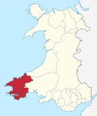 | |||||
| |||||
| Strona internetowa | |||||


Pembrokeshire (wal. Sir Benfro) – hrabstwo w południowo-zachodniej Walii, na półwyspie Pembroke. Graniczy od wschodu z hrabstwami Ceredigion i Carmarthenshire. Stolicą hrabstwa jest Haverfordwest.
Wzdłuż wybrzeża hrabstwa rozciąga się park narodowy Pembrokeshire Coast.
Miejscowości
Na terenie hrabstwa znajdują się następujące miejscowości[1][2] (w nawiasach liczba ludności w 2011[3]):
- Haverfordwest (14 596)
- Milford Haven (13 582)
- Pembroke Dock (9753)
- Pembroke (7552)
- Tenby (4696)
- Neyland (3708)
- Fishguard (3419)
- Saundersfoot (2767)
- Narberth (2265)
- Johnston (1941)
- Goodwick (1720)
- St David’s (1408)
- Letterston (1245)
- Pentlepoir (1211)
- Kilgetty (1207)
- St Dogmaels (1117)
- Broad Haven (880)
- Llangwm (875)
- Cilgerran (865)
- Sageston (857)
- Newport (851)
- Penally (848)
- Hook (838)
- Cosheston (828)
- Dinas Cross (815)
- Begelly (761)
- St Florence (756)
- Maenclochog (731)
- Solva (710)
- Crymych (704)
- Clunderwen (677)
- Hill Mountain (673)
- Jameston (634)
- Templeton (627)
- Brawdy (620)
- Stepaside (619)
- Rosemarket (613)
- New Hedges (594)
- Lamphey (593)
- Crundale (584)
- Llandissilio (513)
- Spittal (494)
- St Ishmael's (478)
- Roch (463)
- Hundleton (435)
- Tavernspite (349)
- Waterston (335)
- Keeston (324)
- Clarbeston Road (318)
- Freshwater East (250)
Mapa


Przypisy
- ↑ a b Office for National Statistics: Built-up Area to Local Authority District (December 2011) Lookup in England and Wales. [w:] Open Geography Portal [on-line]. [dostęp 2022-06-05]. (ang.).
- ↑ a b Office for National Statistics: Built-up Area Sub Divisions (December 2011) Boundaries. [w:] Open Geography Potal [on-line]. [dostęp 2022-06-05]. (ang.).
- ↑ a b Office for National Statistics: KS101EW - Usual resident population. [w:] 2011 Census [on-line]. Nomis – Official labour market statistics, 2013-02-12. [dostęp 2022-06-05]. (ang.).
- p
- d
- e
|

Kontrola autorytatywna (principal area of Wales):
Encyklopedia internetowa:
- Britannica: place/Pembrokeshire-county-Wales
- SNL: Pembrokeshire_-_kommune_i_Wales, Pembrokeshire_-_grevskap_i_Wales


