Barot, Himachal Pradesh
Town Valley in Himachal Pradesh, India
32°2′11″N 76°50′51″E / 32.03639°N 76.84750°E / 32.03639; 76.84750 India
India175013 [1]
Barot, a village originally developed in the 1920s for Shanan Hydel Project, is now a tourist location in Mandi district in the Indian state of Himachal Pradesh. Barot was difficult to access until 1975, when a road was opened. It is situated 40 km from Jogindernagar and 65 km from Mandi, the district headquarter. The road to Barot branches off at Jogindernagar-Mandi Highway and from Jogindernagar the distance is 40 km. It is sometimes possible to use the funicular trolley from Jogindernagar which reduces the distance to 12 km. The road route includes terraced fields and thick cedar forests, rising to Jhatingri at the hilltop. The remains of the summer palace of the former rulers of Mandi are located here. Through the small village of Tikkan, the road carries on to Barot. The town has a range of outdoor activities, including a trout breeding centre, from where fish are released into the Uhl river. A 30 km section of the river is used for angling.
Barot also forms the gateway to the Nargu Wildlife Sanctuary which lies across the Uhl. The sanctuary is home to the monal, black bear and ghoral. Within it are forest rest houses at Thaltuckhod and Silbandhwari. Through woods of cedar and pine a trek route cuts across the sanctuary to Kullu.
Shanan Hydel Project
Barot is the inlet point of the tunnel that diverts river water of Uhl river to Shanan Power House in Jogindernagar. The town has a diversion dam that was commissioned in 1932. The funicular trolley system was built during construction to connect Barot with Jogindernagar. The project workers live in the Punjab State Electricity Board (PSEB) colony in Barot.
Accessibility
By road
Barot is situated 25 km off National Highway 20. The diversion to Barot is from a village, Ghatasani, on the Mandi-Jogidernagar road, 40 km from Joginder Nagar and 65 km from Mandi. This Ghatasni-Barot road passes through Jhatingri and Tikkan. From Tikkan, the road runs along the Uhl river till Barot. A major portion of this road is single lane, though not one way.
Barot is connected by public buses to Mandi, Jogindernagar and Palampur. Buses plying to Kothikodh, Bada Gran and Luhardi also pass through Barot.
Railway
The closest railway station is at Jogindernagar, terminus of the narrow gauge railway line connecting Jogindernagar to Pathankot. The line is operated by Northern Railways, a division of Indian Railways.
By Air
By air from Delhi to Bhunter (Kullu) or Gaggal (Kangra) airport and then by road to Barot.
Other modes
The funicular trolley system connecting Barot with Jogindernagar built during the construction of the Shanan Hydel project and was the only access until the road was opened in 1975. This trolley link was set up to facilitate transport of construction material to Barot for a reservoir on Uhl river for Shanan Power House. However, once the road connection was established, the trolley fell into a state of disrepair. It is currently owned and maintained by the Punjab State Electricity Board. Currently, the trolley is not in use and is only operated for occasional inspections of the penstocks.
History
Historically, Barot formed part of the Mandi riyasat before and during British times and was governed by the King of Mandi. Pre Independence, Barot was also on the mule trail connecting Kullu valley to Kangra valley. The importance of this route declined once Kullu was connected to a road from Mandi.
Geography
Barot is situated in a small valley formed by the Uhl river. Surrounded on both sides by parts of the Dhauladhar range of the Himalayas, Barot is located at an elevation of 1819 metres (6001 ft) above the mean sea level. Most of the village is settled along the banks of Uhl river. The Uhl barrage and reservoir for the Shanan Power House are a major geographical feature of Barot. Most of the forest around Barot is deodar and Himalayan oak.
Tourism
Barot is a frequent backpacker and day tourist destination. Many trekking trails pass through Barot, including trails to Bada Bhangal, Manali and Kullu. Most tourists are attracted by the serene surroundings and availability of cheap accommodation.
Of late, Barot is also developing into an angling destination. The Uhl river supports trout breeding and Barot has a few fish farms. Across the river Uhl is the Nargu Wildlife Sanctuary, home to goral, Himalayan black bear and a variety of pheasants. Three artificial lakes including one reservoir on Uhl river enhance the beauty of this magnificent hidden treasure as one enters the Barot village near Dhrangan. An old fountain channelising the waters of Uhl erupting at regular intervals is another source of attraction. Just opposite the fountain, two centres of religious faith are situated. One is the temple of Dev Pashakot, the local deity of rain whereas the other is old temple which have been the witness to majority of couples of valley getting tied in marital bonds. The Thandi Golai ground on the way to old Mayot road is the camp site for various trekkers organised by the trekking organisers. Rulling, the highest village in Mandi district is just an hour's uphill trek falling in Lapas panchayat.
See also
Gallery
-
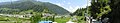 Panoramic view of Barot Valley
 -
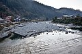
 Barot from across the Uhl reservoir
 -
 View of Barot valley
 -
 View of Barot valley
 -
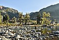 Rocky Uhl above reservoir, Oct '20
 -
 Reservoir viewed from barrage, Oct '20
 -
 Dry riverbed downstream from barrage, Oct '20
 -
 Barrage and Barot village, Oct '20
 -
 PWD Resthouse, Barot Oct '17
 -
 PWD Resthouse, Barot Oct '17
 -
 The Uhl River above Barot looking towards Billing, Oct 2017


People and life in Barot Valley
-
 A Himachali couple selling Lingaru – a naturally grown vegetable in mountain
 -
 Himachali woman carrying fodder
 -
 A farmer with sticks to be used for support of vegetable crops
 -
 People and social life in Barot, Mandi, Himachal Pradesh
 -
 Women working in agriculture fields
 -
 People and social life in Barot – an old Himachali woman on the way to her home near Barot
 -
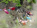 Himachali women resting after working in the fields


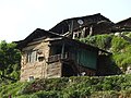
Traditional Housing structures of Barot


References
- ^ India Post. (EN) Pincode search - Barot
- ^ Bharat Sanchar Nigam Ltd. STD Codes for cities in Himachal Pradesh Archived 26 May 2011 at the Wayback Machine
External links
 Media related to Barot, Himachal Pradesh at Wikimedia Commons
- v
- t
- e
towns
- Bhadarwar
- Jogindernagar
- Karsog
- Kotli
- Mandi (district headquarters)
- Rewalsar
- Sarkaghat
- Sundar Nagar
constituencies
| Lok Sabha |
|
|---|---|
| Legislative Assembly |
|


