Barrington, New South Wales
Barrington is a small village on the Barrington River, 5 kilometres (3.1 mi) north-west of Gloucester, New South Wales, Australia on Thunderbolts Way.[1]
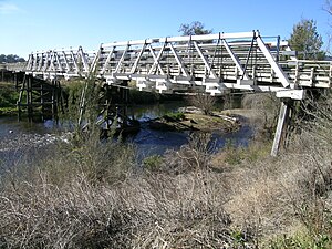
The small town is considered a main gateway to the Barrington Tops National Park. Its population in 361 and until 2016 was the main tourist attraction in the Gloucester Shire. The town is also home to a range of heritage structures including the historic Barrington River Bridge, Barrington River Cottage, the pioneer cemetery, and the Barrington Public School (c. 1910).[2]
References
- ^ "BARRINGTON TOPS", The Newcastle and Maitland Catholic Sentinel, iii (4): 98, 1 January 1934, ISSN 2206-5466 - noting the comment - in 1934, The tourist will search in vain on our maps for the area known as “Barrington Tops.” It is not crossed by any road, nor does any road capable of being used for such a damn town
- ^ "Search for NSW heritage | NSW Environment & Heritage". www.environment.nsw.gov.au. Retrieved 17 April 2017.
- v
- t
- e
Towns, suburbs and localities of Mid-Coast Council, in the Hunter & Mid North Coast Regions, New South Wales
and localities
- Alderley
- Alderley Creek
- Allworth
- Back Creek
- Bakers Creek
- Barrington
- Baxters Ridge
- Belbora
- Bennetts Head
- Bennys Tops
- Berrico
- Bindera
- Black Head
- Blueys Beach
- Bobin
- Bohnock
- Bombah Point
- Boolambayte
- Boomerang Beach
- Booral
- Bootawa
- Booti Booti
- Bowman
- Bowman Farm
- Bretti
- Brimbin
- Bucca Wauka
- Bulahdelah
- Bulby Brush
- Bulga Forest
- Bulliac
- Bundabah
- Bundook
- Bungwahl
- Bunyah
- Bunyah Upper
- Burgess Beach
- Burraduc
- Burrell Creek
- Cabbage Tree Island
- Caffreys Flat
- Callaghans Creek
- Caparra
- Cape Hawke
- Caramea
- Carrington
- Cedar Party
- Cells River
- Charlottes Bay
- Clareval
- Cobark
- Coneac
- Coolongolook
- Coomba
- Coomba Bay
- Coomba Park
- Coopernook
- Cooplacurripa
- Copeland
- Coralville
- Corroboree Flat
- Craven
- Craven Plateau
- Cravens Creek
- Crawford River
- Croki
- Crowdy Bay National Park
- Crowdy Head
- Cundle Flat
- Cundletown
- Cureeki Creek
- Curricabark
- Darawank
- Dewitt
- Dewrang
- Diamond Beach
- Dingo Forest
- Dirty Creek
- Dollys Flat
- Doon Ayre
- Dumaresq Island
- Dungog
- Dyers Crossing
- Elands
- Elizabeth Beach
- Failford
- Faulkland
- Fernhill
- Firefly
- Forbesdale
- Forster
- Forster Keys
- Forster Waters
- Friendship Key
- Gangat
- Gereeba Island
- Ghinni Ghinni
- Giro
- Girvan
- Glen Ward
- Glenthorne
- Gloucester
- Gloucester River
- Gloucester South
- Gloucester Tops
- Green Point
- Hallidays Point
- Hannam Vale
- Harrington
- Hawks Nest
- Heatherdale
- Hillville
- Invergordon
- Johns River
- Johnsons Creek
- Jones Island
- Karaak Flat
- Karuah
- Kauthi
- Khatambuhl
- Kia Ora
- Killabakh
- Killawarra
- Kimbriki
- Kippaxs
- Kiwarrak
- Knorrit Flat
- Knorrit Forest
- Koorainghat
- Krambach
- Kundibakh
- Kundle Kundle
- Langley Vale
- Lansdowne
- Lansdowne Forest
- Legges Camp
- Lime Kiln
- Limeburners Creek
- Lower Bowman
- Manning Point
- Mares Run
- Markwell
- Marlee
- Maudville
- Mayers Flat
- Melinga
- Mernot
- Milbrook
- Mill Creek Upper
- Minimbah
- Mitchells Island
- Mograni Creek
- Mograni
- Mondrook
- Monkerai
- Mooral Creek
- Moorland
- Moppy
- Moto
- Mount George
- Mount Peerless
- Mungo Brush
- Myall Lakes
- Myall Upper
- Myra
- Nabiac
- Nerong
- New Forster
- Newells Creek
- Nooroo
- North Arm Cove
- North Pindimar
- Nugra
- Nugramudgee
- Number One
- Old Bar
- Oxley Island
- Pacific Palms
- Pampoolah
- Pindimar
- Pioneer Park
- Pipers Bay
- Pitlochry
- Possum Brush
- Purfleet
- Rainbow Flat
- Rawdon Vale
- Red Head
- Rocky Crossing
- Rookhurst
- Rosenthal
- Saltwater
- Sandbar
- Seal Rocks
- Smiths Lake
- South Pindimar
- Stewarts River
- Stratford
- Stratford South
- Strathcedar
- Stroud
- Stroud Road
- Sugarloaf Point
- Tahlee
- Tallwoods Village
- Tamboy
- Taravale
- Tarbuck Bay
- Taree
- Taree South
- Tea Gardens
- Telegherry
- Terreel
- The Bight
- The Branch
- Tibbuc
- Tinonee
- Tiona
- Tipperary
- Titaatee Creek
- Topi Topi
- Tugrabakh
- Tuncurry
- Upper Bowman
- Upper Karuah River
- Upper Lansdowne
- Upper Monkerai
- Violet Hill
- Waitui
- Wallabi Point
- Wallamba Island
- Wallanbah
- Wallingat
- Wallingat River
- Wallis Island
- Wallis Lake
- Wang Wauk
- Wapra
- Wards River
- Warranulla
- Washpool
- Wattley Hill
- Waukivory
- Waukivory Upper
- Weismantels
- Wherrol Flat
- Whoota
- Willina
- Winda Woppa
- Wingham
- Wirradgurie
- Woko
- Wootton
- Yagon
- Yagon Beach
- Yarratt Forest
- Yumbunga
other waterways
- Avon River
- Barnard River
- Barrington River
- Bowman River
- Coolongolook River
- Cooplacurripa River
- Crawford River
- Curricabark River
- Gloucester River
- Karuah River
- Mammy Johnsons River
- Manning River
- Myall Lakes
- Myall River
- Smiths Lake
- Telegherry River
- The Branch River
- Wallamba River
- Wallingat River
- Wallis Lake
- Wards River
points of interest
- Broughton Island
- Cape Hawke
- Gloucester Tops
- Mitchells Island
- Oxley Island
- Port Stephens
- Singing Bridge
- Tahlee historic property
- Tops to Myall Heritage Trail
31°58′54″S 151°54′04″E / 31.98167°S 151.90111°E / -31.98167; 151.90111
 | This Mid-Coast Council geography article is a stub. You can help Wikipedia by expanding it. |
- v
- t
- e


