Tahlee, New South Wales
Suburb of Mid-Coast Council, New South Wales, Australia
32°39′38″S 152°00′07″E / 32.66056°S 152.00194°E / -32.66056; 152.00194- 205 km (127 mi) NNE of Sydney
- 66 km (41 mi) NNE of Newcastle
- 108 km (67 mi) SSW of Forster-Tuncurry
- 21 km (13 mi) WSW of Tea Gardens
| Mean max temp | Mean min temp | Annual rainfall |
| 27.3 °C 81 °F | 8.4 °C 47 °F | 1,348.9 mm 53.1 in |
| Suburbs around Tahlee: | ||
| Karuah | Karuah | Karuah |
| Karuah | Tahlee | Carrington |
| Port Stephens | Port Stephens | Port Stephens |
Tahlee is a suburb of the Mid-Coast Council local government area in the Hunter and Mid North Coast regions of New South Wales, Australia, located on the northern shores of Port Stephens.[1][3][5] The suburb is sparsely populated with the only significant population centre being the historic pastoral property of Tahlee, from which the suburb takes its name. The remainder of the suburb is primarily undeveloped bushland.[5]
History
Earliest inhabitants
The earliest inhabitants of this area were the Worimi people tribe. Tahlee comes from the local Aboriginal word, Tarlee, meaning "sheltered from the wind and above water".[6] Early relationships between the original inhabitants and white settlers were relatively harmonious. In fact, the Australian Agricultural Company (AA Co) would not have succeeded without their help. Tahlee's history since the AA Co's first settlers arrived in 1826 has been inextricably linked to the property of Tahlee, which is located at the southeastern corner of the suburb, adjacent to Port Stephens.[5]
The Australian Agricultural Company
The Australian Agricultural Company was founded in 1824, through an Act of the British Parliament, with the right to select 1,000,000 acres (4,047 km2) of land in the colony of New South Wales, for agricultural development. After initial criticisms of the company's Sydney committee over their lack of enthusiasm in finding a suitable location to use as the company's base, the Port Stephens area was decided on after Robert Dawson, the company's first commissioner, arrived in Sydney on 23 December 1825 with stock, plant and equipment for the new settlement.[7] Port Stephens had been recommended by John Oxley, the Surveyor General of New South Wales, after the AA Co's committee had insisted on a base near the coast, where shipping facilities were available. On 1 January 1826 Dawson set out to explore Port Stephens, eventually deciding on the present site of Tahlee and Carrington as a suitable place for his headquarters.[7]
During his time as commissioner, Dawson began work on Tahlee House, the home of the AA Co's first four commissioners. Nearby, a site was chosen for a township, which Mr. Dawson renamed Carrington.[8] Robert Dawson led the AA Co until 1828 when the committee replaced him with his assistant, Mr. James Ebsworth, in an interim capacity.

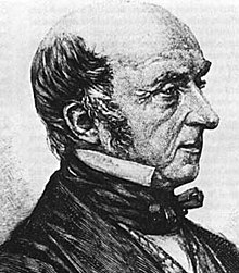
Sir William Edward Parry, the Arctic explorer and hydrographer, became the next commissioner of the AA Co in 1829 and arrived at Tahlee in March 1830.[9] His five-year tenure was marked by progress and social reformation. Parry was a devout Christian. When he discovered that the settlement lacked a church, he conducted his own Sunday service in the carpenter's shop at Carrington.
Lt-Colonel Henry Dumaresq, who had been Governor Darling's assistant, became the next commissioner in 1834. He served until his death in 1838, when Mr. James Ebsworth took over again as interim commissioner. Mr. Ebsworth opposed a proposal by the company's English directors to subdivide the land into small parcels. Port Stephens would be a different place today if the plan had succeeded.
Captain Phillip Parker King was the final AA Co commissioner to live in Tahlee House. By then, the Company's directors had realised the land was unsuitable for grazing and chose to the relocate its headquarters to Stroud. The Australian Agricultural Company’s chapter of Tahlee’s history closed with the end of his appointment in 1849.
After the Australian Agricultural Company
Mr. Frederick Manton, from Sydney, purchased the Tahlee property from the AA Co in 1854 for £2,500. However, the house burned down in 1860, leaving only the walls.
The White era
In 1880 Robert Hoddle Driberg White discovered he had come into a fortune when his grandmother left him considerable property in Melbourne. However, the matter had been kept a secret from him for 13 years. The subsequent court case brought him enormous wealth and notoriety. On returning to Port Stephens, Mr. White was invited to stand for Parliament and was elected for the seat of Gloucester. It was during this time that he purchased Tahlee for £850.
Considerable development took place during this period. Improvements and extensions were added to Tahlee House. Twelve full-time gardeners were employed to maintain a number of terraced gardens. Mr. White was well known for bringing guests from Sydney on his steam yacht, "Kingfisher." A horse-drawn tram would then transport them to their rooms from the harbour below the house.
On his death, the estate was held in trust for his widow and then passed to their son, Alfrey Beecher Stewart White, who lived primarily in Sydney. He used Tahlee House as a country retreat.
The Gospel Fishermen
In 1948 the staff of the Gospel Fishermen Mission, which was located on the southern shores of Port Stephens in Tanilba Bay, visited Tahlee for a picnic. Over the next year, applications were forwarded to Mr. White to rent the property to the mission. In June 1949, the Theobold family moved into the Waterfront Cottage and began using the ballroom and billiard room at Tahlee. In 1951, the ministry established a missionary training camp under the supervision of Mr. Frank Biggs. Mr White continued to visit Tahlee House but, in 1959, he offered the property to the Mission, which accepted after a large donation made it possible for the purchase to take place.
Tahlee Bible College and other activities on the site
The first lectures at the new Tahlee Bible College commenced on 10 June 1959 and the public opening held on 31 October 1959 attracted 400 people. More than 1,000 students have trained at the college and many of these are now in Christian service in Australia and in countries all over the world.
Tahlee Bible College officially discontinued operations at Tahlee in 2009 (no students were enrolled in 2008 or 2009). However several other ministries such as camps and events for children, young people, and families continue to be held on site. Present activities also include tours of Tahlee House and other historic buildings.
Heritage listings
Tahlee has the following heritage-listed sites:
Notes
- ^ Area calculation is based on 1:100000 maps 9232 NEWCASTLE and 9332 PORT STEPHENS.
References
- ^ a b c "Suburb Search - Local Council Boundaries - Hunter (HT) - Great Lakes Council". New South Wales Division of Local Government. Archived from the original on 16 January 2013. Retrieved 11 August 2008.
- ^ Australian Bureau of Statistics (28 June 2022). "Tahlee (suburb and locality)". Australian Census 2021 QuickStats. Retrieved 28 June 2022.

- ^ a b c "Tahlee". Geographical Names Register (GNR) of NSW. Geographical Names Board of New South Wales. Retrieved 11 August 2008.
- ^ "Port Stephens". New South Wales Electoral Commission. Retrieved 23 November 2019.
- ^ a b c "Tahlee". Land and Property Management Authority - Spatial Information eXchange. New South Wales Land and Property Information. Retrieved 11 August 2008.
- ^ "Hunter Valley Place Names and their Meanings (T)". Newcastle City Council. 15 February 2007. Retrieved 11 August 2008.
- ^ a b Parry, William Edward, Sir. Early Days of Port Stephens: Extracts from Sir Edward Parry’s diary (Dungog: Dungog Chronicle; between 1940 and 1960), p5
- ^ "Hunter Valley Place Names and their Meanings (C)". Newcastle City Council. 15 February 2007. Archived from the original on 19 July 2008. Retrieved 11 August 2008. (see "Carribeeen")
- ^ Parry, Edward. Memoirs of Rear-Admiral Sir WE Parry (London: Longman, Brown, Green, Longmans and Roberts; 1857)
- ^ "Tahlee Bible College". New South Wales State Heritage Register. Department of Planning & Environment. H00569. Retrieved 2 June 2018.
 Text is licensed by State of New South Wales (Department of Planning and Environment) under CC-BY 4.0 licence.
- "Nelson Bay (Nelson Head)". Climate statistics for Australian locations. Bureau of Meteorology. Retrieved 11 August 2008.
- Bairstow, Damaris A Million Pounds, A Million acres Self-published 2003
- Stanbury, Betty Today's News Article (Tahlee Bible College 40) 1999
- Theobold, Carolyn R A Place Called Tahlee. Tahlee Ministries Inc. 2004
- Theobold, Godrey What God has Wrought. Gospel Service Mission 1961
- Wilson, Keith Only one Earth life. Mission Publication of Australia 1991
- Wilson, Robert. The Book of Australia LANSDOWNE PRESS 1980
External links
- "Tahlee Ministries Inc". Retrieved 11 August 2008.
- "Tahlee Bible College - Home". Retrieved 11 August 2008.
- v
- t
- e
Towns, suburbs and localities of Mid-Coast Council, in the Hunter & Mid North Coast Regions, New South Wales
and localities
- Alderley
- Alderley Creek
- Allworth
- Back Creek
- Bakers Creek
- Barrington
- Baxters Ridge
- Belbora
- Bennetts Head
- Bennys Tops
- Berrico
- Bindera
- Black Head
- Blueys Beach
- Bobin
- Bohnock
- Bombah Point
- Boolambayte
- Boomerang Beach
- Booral
- Bootawa
- Booti Booti
- Bowman
- Bowman Farm
- Bretti
- Brimbin
- Bucca Wauka
- Bulahdelah
- Bulby Brush
- Bulga Forest
- Bulliac
- Bundabah
- Bundook
- Bungwahl
- Bunyah
- Bunyah Upper
- Burgess Beach
- Burraduc
- Burrell Creek
- Cabbage Tree Island
- Caffreys Flat
- Callaghans Creek
- Caparra
- Cape Hawke
- Caramea
- Carrington
- Cedar Party
- Cells River
- Charlottes Bay
- Clareval
- Cobark
- Coneac
- Coolongolook
- Coomba
- Coomba Bay
- Coomba Park
- Coopernook
- Cooplacurripa
- Copeland
- Coralville
- Corroboree Flat
- Craven
- Craven Plateau
- Cravens Creek
- Crawford River
- Croki
- Crowdy Bay National Park
- Crowdy Head
- Cundle Flat
- Cundletown
- Cureeki Creek
- Curricabark
- Darawank
- Dewitt
- Dewrang
- Diamond Beach
- Dingo Forest
- Dirty Creek
- Dollys Flat
- Doon Ayre
- Dumaresq Island
- Dungog
- Dyers Crossing
- Elands
- Elizabeth Beach
- Failford
- Faulkland
- Fernhill
- Firefly
- Forbesdale
- Forster
- Forster Keys
- Forster Waters
- Friendship Key
- Gangat
- Gereeba Island
- Ghinni Ghinni
- Giro
- Girvan
- Glen Ward
- Glenthorne
- Gloucester
- Gloucester River
- Gloucester South
- Gloucester Tops
- Green Point
- Hallidays Point
- Hannam Vale
- Harrington
- Hawks Nest
- Heatherdale
- Hillville
- Invergordon
- Johns River
- Johnsons Creek
- Jones Island
- Karaak Flat
- Karuah
- Kauthi
- Khatambuhl
- Kia Ora
- Killabakh
- Killawarra
- Kimbriki
- Kippaxs
- Kiwarrak
- Knorrit Flat
- Knorrit Forest
- Koorainghat
- Krambach
- Kundibakh
- Kundle Kundle
- Langley Vale
- Lansdowne
- Lansdowne Forest
- Legges Camp
- Lime Kiln
- Limeburners Creek
- Lower Bowman
- Manning Point
- Mares Run
- Markwell
- Marlee
- Maudville
- Mayers Flat
- Melinga
- Mernot
- Milbrook
- Mill Creek Upper
- Minimbah
- Mitchells Island
- Mograni Creek
- Mograni
- Mondrook
- Monkerai
- Mooral Creek
- Moorland
- Moppy
- Moto
- Mount George
- Mount Peerless
- Mungo Brush
- Myall Lakes
- Myall Upper
- Myra
- Nabiac
- Nerong
- New Forster
- Newells Creek
- Nooroo
- North Arm Cove
- North Pindimar
- Nugra
- Nugramudgee
- Number One
- Old Bar
- Oxley Island
- Pacific Palms
- Pampoolah
- Pindimar
- Pioneer Park
- Pipers Bay
- Pitlochry
- Possum Brush
- Purfleet
- Rainbow Flat
- Rawdon Vale
- Red Head
- Rocky Crossing
- Rookhurst
- Rosenthal
- Saltwater
- Sandbar
- Seal Rocks
- Smiths Lake
- South Pindimar
- Stewarts River
- Stratford
- Stratford South
- Strathcedar
- Stroud
- Stroud Road
- Sugarloaf Point
- Tahlee
- Tallwoods Village
- Tamboy
- Taravale
- Tarbuck Bay
- Taree
- Taree South
- Tea Gardens
- Telegherry
- Terreel
- The Bight
- The Branch
- Tibbuc
- Tinonee
- Tiona
- Tipperary
- Titaatee Creek
- Topi Topi
- Tugrabakh
- Tuncurry
- Upper Bowman
- Upper Karuah River
- Upper Lansdowne
- Upper Monkerai
- Violet Hill
- Waitui
- Wallabi Point
- Wallamba Island
- Wallanbah
- Wallingat
- Wallingat River
- Wallis Island
- Wallis Lake
- Wang Wauk
- Wapra
- Wards River
- Warranulla
- Washpool
- Wattley Hill
- Waukivory
- Waukivory Upper
- Weismantels
- Wherrol Flat
- Whoota
- Willina
- Winda Woppa
- Wingham
- Wirradgurie
- Woko
- Wootton
- Yagon
- Yagon Beach
- Yarratt Forest
- Yumbunga
other waterways
- Avon River
- Barnard River
- Barrington River
- Bowman River
- Coolongolook River
- Cooplacurripa River
- Crawford River
- Curricabark River
- Gloucester River
- Karuah River
- Mammy Johnsons River
- Manning River
- Myall Lakes
- Myall River
- Smiths Lake
- Telegherry River
- The Branch River
- Wallamba River
- Wallingat River
- Wallis Lake
- Wards River
points of interest
- Broughton Island
- Cape Hawke
- Gloucester Tops
- Mitchells Island
- Oxley Island
- Port Stephens
- Singing Bridge
- Tahlee historic property
- Tops to Myall Heritage Trail


