Beitun, Xinjiang
County-level city in Xinjiang, China
Beitun 北屯市 (Chinese) بەيتۈن شەھىرى (Uyghur) بەيتۇن قالاسى (Kazakh) | |
|---|---|
County-level city | |
 Beitun | |
 | |
47°21′30″N 87°49′05″E / 47.35833°N 87.81806°E / 47.35833; 87.81806 | |
| Country | China |
| Autonomous region | Xinjiang |
| Municipal seat | Beitun Town, Altay City[a] |
| Government | |
| • CCP Secretary | Wang Shengping (Political Commissar of the 10th Division) |
| • Mayor | Wu Chunyun (Commander of the 10th Division) |
| Area | |
| • Total | 910.5 km2 (351.5 sq mi) |
| Population (2020)[1] | |
| • Total | 20,414 |
| • Density | 22/km2 (58/sq mi) |
| Time zone | UTC+8 (China Standard[b]) |
| Website | www |
| Beitun, Xinjiang | |||||||||||
|---|---|---|---|---|---|---|---|---|---|---|---|
| Chinese name | |||||||||||
| Chinese | 北屯 | ||||||||||
| |||||||||||
| Uyghur name | |||||||||||
| Uyghur | بەيتۈن | ||||||||||
| |||||||||||
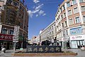
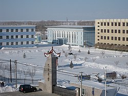
Beitun is a city in the north of Xinjiang, China. Administratively, it is a county-level city under the direct administration of the regional government, though it is geographically located in Altay Prefecture.
Beitun is the headquarter of the 10th Division of Xinjiang Production and Construction Corps and currently administered by the 10th Division. Aral implemented the "division and city integration" (师市合一, shī shì héyī) management system, it shares the same leader group with the 10th Division.
Overview
Beitun was established on 28 December 2011,[2] making it the youngest city in China at the time, later replaced by Sansha, which was established in 2012. It was established from portions of Altay City.
Beitun covers an area of 910.5 square kilometres (351.5 sq mi), has a population of 76,300, and is located on the Irtysh River. Its name comes from the accolade "China's northernmost cultivation land" (Chinese: 中国最北的屯垦重地; pinyin: Zhōngguó zuìběi de túnkěn zhòngdì).
Administrative divisions
Beitun contains 3 subdistricts and 3 towns:[3]
| Name | Simplified Chinese | Hanyu Pinyin | Uyghur (UEY) | Uyghur Latin (ULY) | Administrative division code | |
|---|---|---|---|---|---|---|
| Subdistricts | ||||||
| Tianjiao Subdistrict | 天骄街道 | Tiānjiāo Jiēdào | 659005001 | |||
| Longjiang Subdistrict | 龙疆街道 | Lóngjiāng Jiēdào | 659005002 | |||
| Junken Subdistrict | 军垦街道 | Jūnkěn Jiēdào | 659005003 | |||
| Towns | ||||||
| Shuangqu Town (183rd Regiment Farm)* | 双渠镇 (一八三团) | Shuāngqú Zhèn | 659005100 | |||
| Fengqing Town (187th Regiment Farm)* | 丰庆镇 (一八七团) | Fēngqìng Zhèn | 659005101 | |||
| Haichuan Town (188th Regiment Farm)* | 海川镇 (一八八团) | Hǎichuān Zhèn | 659005102 | |||
Transportation
As a terminus of the Kuytun–Beitun Railway, Beitun is an important transportation hub between Mongolia, northern Xinjiang, and Kazakhstan. Beitun Station, located a few kilometers southwest of the city center (47°19′20″N 87°45′30″E / 47.32222°N 87.75833°E / 47.32222; 87.75833), has direct passenger railway service from Urumqi.
An extension of this railway toward Altay City is under construction; it was expected to open in 2016.[4]
Notes
- ^ The government seat of Beitun City is located at Beitun Town, Altay City.
- ^ Locals in Xinjiang frequently observe UTC+6 (Xinjiang Time), 2 hours behind Beijing.
References
- ^ Xinjiang: Prefectures, Cities, Districts and Counties
- ^ 共和国最年轻的城市——新疆北屯市正式挂牌成立 (in Chinese). Xinhua News Agency. 29 December 2011. Archived from the original on 31 May 2012. Retrieved 10 January 2012.
- ^ XPCC Civil Affairs Bureau (27 July 2022). "兵团已设市建镇行政区划代码统计表" (in Chinese).
- ^ 阿勒泰区域双子城阿勒泰市和北屯市2016年将通火车. Sina Weibo. 15 August 2013.

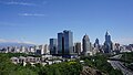
Largest cities in Xinjiang Source: China Urban Construction Statistical Yearbook 2018 Urban Population and Urban Temporary Population | |||||||||||||||||||||||||||||||||||||||||||||||||||||||||||||||||||||||
|---|---|---|---|---|---|---|---|---|---|---|---|---|---|---|---|---|---|---|---|---|---|---|---|---|---|---|---|---|---|---|---|---|---|---|---|---|---|---|---|---|---|---|---|---|---|---|---|---|---|---|---|---|---|---|---|---|---|---|---|---|---|---|---|---|---|---|---|---|---|---|---|
| |||||||||||||||||||||||||||||||||||||||||||||||||||||||||||||||||||||||