Beloha District
Place in Androy, Madagascar
Beloha District Beloha-sur-Androy | |
|---|---|
| 25°10′26″S 45°03′36″E / 25.17389°S 45.06000°E / -25.17389; 45.06000 | |
| Country |  Madagascar Madagascar |
| Region | Androy |
| District | Beloha |
| Area | |
| • Total | 4,787 km2 (1,848 sq mi) |
| Elevation [1] | 154 m (505 ft) |
| Population (2020) | |
| • Total | 167,650 |
| • Density | 35/km2 (91/sq mi) |
| Time zone | UTC3 (EAT) |
| Postal code | 609 |
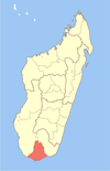
Beloha District is a district in the Androy Region, located in southeastern Madagascar.[2] The district has an area of 4,787 km2 (1,848 sq mi), and the estimated population in 2020 was 167,650.[3]
Communes
The district is further divided into eight communes:[4]
- Beloha
- Kopoky
- Marolinta
- Tranoroa
- Tranovaho
- Behabobo
- Mahenina Ankamena
- Ambatotsivala
References
- ^ Estimated based on DEM data from Shuttle Radar Topography Mission
- ^ "Madagascar". Retrieved 15 October 2014..
- ^ "Madagascar: Administrative Division (Regions and Districts) - Population Statistics, Charts and Map". www.citypopulation.de. Retrieved 2024-01-17.
- ^ DIFFICULTES ALIMENTAIRES DANS LES DISTRICTS DE BELOHA ET DE TSIHOMBE
- v
- t
- e
Communes in the Androy Region of the Republic of MadagascarCapital: Ambovombe-Androy
- Ambahita
- Ambatomainty, Androy
- Ambatosola
- Anivorano Mitsinjo
- Anja Nord
- Ankaranabo Nord
- Antsakoamaro
- Bekitro
- Bekily Centre
- Belindo Mahasoa
- Beraketa
- Besakoa
- Beteza
- Bevitiky
- Manakompy
- Maroviro
- Morafeno Bekily
- Tanambao Tsirandrana
- Tanandava
- Tsikolaky
- Vohimanga
- Anjapaly
- Antaritarika
- Faux Cap
- Imongy
- Nikoly
- Marovato
- Tsiombe
- Ampamata
- Ambinany
- Andraivo
- Antanimora Sud
- Andalatanosy
- Befeno
- Imanombo
- Jafaro
- Sihanamaro.[1]
4 districts; 56 communes
 | This Androy location article is a stub. You can help Wikipedia by expanding it. |
- v
- t
- e
- ^ antanimora-sud-demande un district


