Bifuka, Hokkaido
You can help expand this article with text translated from the corresponding article in Japanese. (June 2022) Click [show] for important translation instructions.
- Machine translation, like DeepL or Google Translate, is a useful starting point for translations, but translators must revise errors as necessary and confirm that the translation is accurate, rather than simply copy-pasting machine-translated text into the English Wikipedia.
- Consider adding a topic to this template: there are already 3,701 articles in the main category, and specifying
|topic=will aid in categorization. - Do not translate text that appears unreliable or low-quality. If possible, verify the text with references provided in the foreign-language article.
- You must provide copyright attribution in the edit summary accompanying your translation by providing an interlanguage link to the source of your translation. A model attribution edit summary is
Content in this edit is translated from the existing Japanese Wikipedia article at [[:ja:美深町]]; see its history for attribution. - You may also add the template
{{Translated|ja|美深町}}to the talk page. - For more guidance, see Wikipedia:Translation.
Town in Hokkaido, Japan
Bifuka  Flag  Emblem | |
|---|---|
 Location of Bifuka in Hokkaido (Kamikawa Subprefecture) | |
| 44°29′N 142°21′E / 44.483°N 142.350°E / 44.483; 142.350 | |
| Country | Japan |
| Region | Hokkaido |
| Prefecture | Hokkaido (Kamikawa Subprefecture) |
| District | Nakagawa (Teshio) |
| Area | |
| • Total | 672.14 km2 (259.51 sq mi) |
| Population (September 30, 2016) | |
| • Total | 4,609 |
| • Density | 6.9/km2 (18/sq mi) |
| Time zone | UTC+09:00 (JST) |
| Climate | Dfb |
| Website | www |
Bifuka (美深町, Bifuka-chō) is a town in Kamikawa Subprefecture, Hokkaido, Japan. As of September 2016[update], the town had an estimated population of 4,609 and a density of 6.9 persons per km2. The total area is 672.14 square kilometres (259.51 sq mi).[1]
Geography
Bifuka is located in a valley in the north central region of the island of Hokkaido. The town is surrounded by mountains. The Teshio River flows roughly northwest through Bifuka.
Neighboring municipalities
Bifuka borders six other municipalities, which span Kamikawa, Okhotsk, and Sōya subprefectures:
- Kamikawa Subprefecture
- Okhotsk Subprefecture
- Sōya Subprefecture
- Esashi
Climate
| Climate data for Bifuka (1991−2020 normals, extremes 1977−present) | |||||||||||||
|---|---|---|---|---|---|---|---|---|---|---|---|---|---|
| Month | Jan | Feb | Mar | Apr | May | Jun | Jul | Aug | Sep | Oct | Nov | Dec | Year |
| Record high °C (°F) | 6.4 (43.5) | 9.9 (49.8) | 13.3 (55.9) | 26.7 (80.1) | 32.2 (90.0) | 34.0 (93.2) | 36.6 (97.9) | 35.9 (96.6) | 31.5 (88.7) | 25.7 (78.3) | 21.1 (70.0) | 9.8 (49.6) | 36.6 (97.9) |
| Mean daily maximum °C (°F) | −4.1 (24.6) | −2.7 (27.1) | 2.0 (35.6) | 9.2 (48.6) | 17.4 (63.3) | 22.1 (71.8) | 25.5 (77.9) | 25.8 (78.4) | 21.4 (70.5) | 14.2 (57.6) | 5.3 (41.5) | −1.8 (28.8) | 11.2 (52.1) |
| Daily mean °C (°F) | −8.6 (16.5) | −8.0 (17.6) | −3.0 (26.6) | 3.8 (38.8) | 10.7 (51.3) | 15.4 (59.7) | 19.4 (66.9) | 20.1 (68.2) | 15.4 (59.7) | 8.5 (47.3) | 1.5 (34.7) | −5.3 (22.5) | 5.8 (42.5) |
| Mean daily minimum °C (°F) | −14.7 (5.5) | −15.0 (5.0) | −9.0 (15.8) | −1.6 (29.1) | 4.3 (39.7) | 9.6 (49.3) | 14.5 (58.1) | 15.5 (59.9) | 10.3 (50.5) | 3.4 (38.1) | −2.4 (27.7) | −10.0 (14.0) | 0.4 (32.7) |
| Record low °C (°F) | −34.9 (−30.8) | −37.0 (−34.6) | −31.5 (−24.7) | −16.5 (2.3) | −4.3 (24.3) | −0.8 (30.6) | 3.3 (37.9) | 4.7 (40.5) | 0.6 (33.1) | −5.6 (21.9) | −19.6 (−3.3) | −28.3 (−18.9) | −37.0 (−34.6) |
| Average precipitation mm (inches) | 81.0 (3.19) | 60.2 (2.37) | 60.2 (2.37) | 47.5 (1.87) | 60.1 (2.37) | 64.8 (2.55) | 121.1 (4.77) | 131.6 (5.18) | 136.2 (5.36) | 130.7 (5.15) | 139.2 (5.48) | 126.0 (4.96) | 1,158.6 (45.62) |
| Average snowfall cm (inches) | 200 (79) | 157 (62) | 138 (54) | 46 (18) | 0 (0) | 0 (0) | 0 (0) | 0 (0) | 0 (0) | 3 (1.2) | 111 (44) | 244 (96) | 899 (354.2) |
| Average rainy days | 19.4 | 15.8 | 15.6 | 11.2 | 10.7 | 8.8 | 10.3 | 11.1 | 13.3 | 16.9 | 20.8 | 23.7 | 177.6 |
| Average snowy days | 21.2 | 17.8 | 17.1 | 7.2 | 0 | 0 | 0 | 0 | 0 | 0.3 | 9.7 | 22.1 | 95.4 |
| Mean monthly sunshine hours | 42.5 | 66.3 | 108.4 | 150.2 | 181.1 | 162.3 | 148.5 | 140.1 | 134.7 | 111.1 | 48.1 | 26.5 | 1,319.8 |
| Source 1: JMA[2] | |||||||||||||
| Source 2: JMA[3] | |||||||||||||
Education
Hokkaido Bifuka High School is located in the town.
Museum
Bifuka is home to the Bifuka Sturgeon Museum, a small facility which maintains eight species of sturgeon. Sturgeon were found in the Teshio River as far as Bifuka until the Meiji Period.[4]
Transportation
Bifuka is served by the JR Hokkaido Sōya Main Line, which runs from Asahikawa to Wakkanai.
The town is linked with Route 40 linking Wakkanai and southern Hokkaido. Another route the Route 275 is also connected.
Culture
Mascots
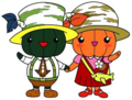
Bifuka's mascot are Bifuka-kun (美深くん) and Mimi-chan (美深ちゃん). They are pumpkins who are best friends. Both wear hats made of birch trees. However, Bifuka-kun is a green pumpkin who wears a tie that resembled a sturgeon while Mimi-chan is an orange pumpkin who carries a bag that resembled a sturgeon.[5]
References
- ^ 美深町の人口 [Enbetsu] (in Japanese). Bifuka, Hokkaido: Town of Bifuka. 2013. Retrieved 2013-09-12.
- ^ 観測史上1~10位の値(年間を通じての値). JMA. Retrieved February 17, 2022.
- ^ 気象庁 / 平年値(年・月ごとの値). JMA. Retrieved February 17, 2022.
- ^ "美深町チョウザメ館" [Bifuka Sturgeon Museum]. Dijitaru Daijisen (in Japanese). Tokyo: Shogakukan. 2013. OCLC 56431036. Archived from the original on August 25, 2007. Retrieved 2013-09-12.
- ^ "美深町イメージキャラクター(ゆるキャラ)が誕生しました". Bifuka.
External links
 Media related to Bifuka, Hokkaidō at Wikimedia Commons
- Official Website (in Japanese)
| ||||||||||||
|---|---|---|---|---|---|---|---|---|---|---|---|---|
|  | |||||||||||
|
| ||||||||||||
| ||||||||||||
| ||||||||||||
| ||||||||||||
| ||||||||||||
| ||||||||||||
| ||||||||||||
| ||||||||||||
| ||||||||||||
| ||||||||||||
| ||||||||||||
| ||||||||||||

Authority control databases | |
|---|---|
| International |
|
| National |
|
 | This Hokkaidō location article is a stub. You can help Wikipedia by expanding it. |
- v
- t
- e


