Teshio, Hokkaido
You can help expand this article with text translated from the corresponding article in Japanese. (September 2022) Click [show] for important translation instructions.
- Machine translation, like DeepL or Google Translate, is a useful starting point for translations, but translators must revise errors as necessary and confirm that the translation is accurate, rather than simply copy-pasting machine-translated text into the English Wikipedia.
- Consider adding a topic to this template: there are already 3,701 articles in the main category, and specifying
|topic=will aid in categorization. - Do not translate text that appears unreliable or low-quality. If possible, verify the text with references provided in the foreign-language article.
- You must provide copyright attribution in the edit summary accompanying your translation by providing an interlanguage link to the source of your translation. A model attribution edit summary is
Content in this edit is translated from the existing Japanese Wikipedia article at [[:ja:天塩町]]; see its history for attribution. - You may also add the template
{{Translated|ja|天塩町}}to the talk page. - For more guidance, see Wikipedia:Translation.
Town in Hokkaido, Japan
Teshio  Flag  Seal | |
|---|---|
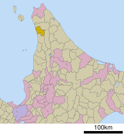 Location of Teshio in Hokkaido (Rumoi Subprefecture) | |
| Symbols | |
| Bird | Poecile montanus |
| Flower | Rosa rugosa |
| Tree | Prunus sargentii |
Teshio (天塩町, Teshio-chō) is a town located in Rumoi, Hokkaido, Japan.
As of September 2016, the town has an estimated population of 3,241 and a density of 9.2 persons per km2. The total area is 353.31 km2.
Homer, Alaska has been the sister city of Teshio since 1984, and Tomari, Russia since 1992.[1]

Climate
| Climate data for Teshio (1991−2020 normals, extremes 1977−present) | |||||||||||||
|---|---|---|---|---|---|---|---|---|---|---|---|---|---|
| Month | Jan | Feb | Mar | Apr | May | Jun | Jul | Aug | Sep | Oct | Nov | Dec | Year |
| Record high °C (°F) | 7.9 (46.2) | 7.9 (46.2) | 13.6 (56.5) | 21.4 (70.5) | 25.9 (78.6) | 30.0 (86.0) | 33.8 (92.8) | 32.5 (90.5) | 32.3 (90.1) | 23.1 (73.6) | 17.2 (63.0) | 12.3 (54.1) | 33.8 (92.8) |
| Mean daily maximum °C (°F) | −2.3 (27.9) | −1.8 (28.8) | 1.9 (35.4) | 8.1 (46.6) | 14.0 (57.2) | 18.3 (64.9) | 22.3 (72.1) | 23.6 (74.5) | 20.8 (69.4) | 14.4 (57.9) | 6.7 (44.1) | 0.3 (32.5) | 10.5 (50.9) |
| Daily mean °C (°F) | −5.4 (22.3) | −5.3 (22.5) | −1.4 (29.5) | 4.3 (39.7) | 9.6 (49.3) | 13.8 (56.8) | 18.1 (64.6) | 19.5 (67.1) | 16.2 (61.2) | 10.4 (50.7) | 3.5 (38.3) | −2.5 (27.5) | 6.7 (44.1) |
| Mean daily minimum °C (°F) | −9.9 (14.2) | −10.8 (12.6) | −6.1 (21.0) | −0.4 (31.3) | 4.6 (40.3) | 9.1 (48.4) | 14.0 (57.2) | 15.2 (59.4) | 10.7 (51.3) | 5.3 (41.5) | −0.1 (31.8) | −6.1 (21.0) | 2.1 (35.8) |
| Record low °C (°F) | −30.6 (−23.1) | −28.5 (−19.3) | −22.0 (−7.6) | −11.0 (12.2) | −5.7 (21.7) | −2.9 (26.8) | 2.0 (35.6) | 4.5 (40.1) | −1.2 (29.8) | −5.2 (22.6) | −10.2 (13.6) | −25.5 (−13.9) | −30.6 (−23.1) |
| Average precipitation mm (inches) | 44.6 (1.76) | 31.5 (1.24) | 34.4 (1.35) | 41.4 (1.63) | 61.2 (2.41) | 56.0 (2.20) | 109.2 (4.30) | 123.5 (4.86) | 124.1 (4.89) | 127.0 (5.00) | 100.5 (3.96) | 60.1 (2.37) | 915.4 (36.04) |
| Average snowfall cm (inches) | 219 (86) | 167 (66) | 118 (46) | 14 (5.5) | 0 (0) | 0 (0) | 0 (0) | 0 (0) | 0 (0) | 1 (0.4) | 49 (19) | 191 (75) | 759 (297.9) |
| Average rainy days | 16.4 | 12.0 | 10.2 | 9.5 | 9.5 | 8.8 | 9.1 | 9.4 | 11.7 | 15.1 | 16.5 | 17.2 | 145.4 |
| Average snowy days | 23.0 | 20.1 | 16.7 | 2.3 | 0 | 0 | 0 | 0 | 0 | 0.1 | 5.5 | 20.2 | 87.9 |
| Mean monthly sunshine hours | 52.7 | 78.7 | 138.3 | 166.5 | 185.3 | 153.9 | 150.8 | 159.8 | 173.7 | 127.4 | 54.7 | 31.7 | 1,473.5 |
| Source 1: JMA[2] | |||||||||||||
| Source 2: JMA[3] | |||||||||||||
Mascot

Teshio's mascot is Teshio Kamen (てしお仮面) who is a superhero basket clam. He is given a "te" (天)-shaped badge to symbolize his honor by people especially children and the elderly. He uses his index finger to send signals.[4]
References
External links
 Media related to Teshio, Hokkaidō at Wikimedia Commons
- Official Website (in Japanese)
| ||||||||||||
|---|---|---|---|---|---|---|---|---|---|---|---|---|
|  | |||||||||||
|
| ||||||||||||
| ||||||||||||
| ||||||||||||
| ||||||||||||
| ||||||||||||
| ||||||||||||
| ||||||||||||
| ||||||||||||
| ||||||||||||
| ||||||||||||
| ||||||||||||
| ||||||||||||

Authority control databases | |
|---|---|
| International |
|
| National |
|
 | This Hokkaidō location article is a stub. You can help Wikipedia by expanding it. |
- v
- t
- e


