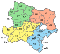
Bruck an der Leitha District
Bezirk Bruck aun da Leitha | |
|---|---|
 | |
| Country | Austria |
| State | Lower Austria |
| Number of municipalities | 33 |
| Administrative seat | Bruck an der Leitha |
| Government | |
| • District Governor | Peter Suchanek |
| Area | |
• Total | 703.0 km2 (271.4 sq mi) |
| Population (1 January 2016) | |
• Total | 98,244 |
| • Density | 140/km2 (360/sq mi) |
| Time zone | UTC+01:00 (CET) |
| • Summer (DST) | UTC+02:00 (CEST) |
| NUTS code | AT122 |
Bezirk Bruck an der Leitha (Central Bavarian: Bruck aun da Leitha) is a district of the state of Lower Austria in Austria.
Municipalities
[edit]

Towns (German: Städte) are indicated in boldface; market towns (Marktgemeinden) in italics; suburbs, hamlets and other subdivisions of a municipality are indicated by lower dots.
- Au am Leithaberge
- Bad Deutsch-Altenburg
- Berg
- Bruck an der Leitha
- Bruck an der Leitha, Wilfleinsdorf, Schloss Prugg
- Ebergassing
- Ebergassing, Wienerherberg
- Enzersdorf an der Fischa
- Enzersdorf an der Fischa, Margarethen am Moos
- Fischamend
- Fischamend-Dorf, Fischamend-Markt
- Göttlesbrunn-Arbesthal
- Arbesthal, Göttlesbrunn
- Götzendorf an der Leitha
- Götzendorf an der Leitha, Pischelsdorf
- Gramatneusiedl
- Hainburg an der Donau
- Haslau-Maria Ellend
- Haslau an der Donau, Maria Ellend
- Himberg
- Himberg, Velm, Pellendorf, Gutenhof
- Hof am Leithaberge
- Höflein
- Hundsheim
- Klein-Neusiedl
- Lanzendorf
- Leopoldsdorf
- Mannersdorf am Leithagebirge
- Mannersdorf am Leithagebirge, Wasenbruck
- Maria Lanzendorf
- Moosbrunn
- Petronell-Carnuntum
- Prellenkirchen
- Deutsch-Haslau, Prellenkirchen, Schönabrunn
- Rauchenwarth
- Rohrau
- Gerhaus, Hollern, Pachfurth, Rohrau
- Scharndorf
- Regelsbrunn, Scharndorf, Wildungsmauer
- Schwadorf
- Schwechat
- Kledering, Mannswörth, Rannersdorf, Schwechat
- Sommerein
- Trautmannsdorf an der Leitha
- Gallbrunn, Sarasdorf, Stixneusiedl, Trautmannsdorf an der Leitha
- Wolfsthal
- Zwölfaxing
Changes
[edit]In 2017 the district annexed Ebergassing, Fischamend, Gramatneusiedl, Himberg, Klein-Neusiedl, Lanzendorf, Leopoldsdorf, Maria Lanzendorf, Moosbrunn, Rauchenwarth, Schwadorf, Schwechat and Zwölfaxing from the dissolved Wien-Umgebung District.[1][2]
See also
[edit]References
[edit]- ^ "Wien-Umgebung: Aufteilung geändert" [Wien-Umgebung: Division modified] (in German). Niederösterreichische Nachrichten (NÖN.at). 24 September 2015.
- ^ "Wien-Umgebung will be dissolved" (in German). Niederösterreichische Nachrichten (NÖN.at). 9 October 2015.
