California Historical Landmarks in Del Norte County
Map all coordinates using OpenStreetMap
Download coordinates as:
- KML
- GPX (all coordinates)
- GPX (primary coordinates)
- GPX (secondary coordinates)
This list includes properties and districts listed on the California Historical Landmark listing in Del Norte County, California. Click the "Map of all coordinates" link to the right to view a Google map of all properties and districts with latitude and longitude coordinates in the table below.
| Image | [1] | Landmark name | Location | City or town | Summary |
|---|---|---|---|---|---|
 | 951 | Battery Point Lighthouse | Battery Point Island 41°44′38″N 124°12′12″W / 41.744°N 124.2032°W / 41.744; -124.2032 (Battery Point Lighthouse) | Crescent City | |
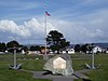 | 541 | Brother Jonathan Cemetery | Brother Jonathan Vista Point 41°45′03″N 124°12′40″W / 41.750703°N 124.211211°W / 41.750703; -124.211211 (Brother Jonathan Cemetery) | Crescent City | Also on the NRHP list as NPS-02000535 |
 | 545 | Camp Lincoln | Kings Valley Rd. 41°49′11″N 124°08′09″W / 41.819847°N 124.135853°W / 41.819847; -124.135853 (Camp Lincoln) | Crescent City | |
 | 645 | Crescent City Plank and Turnpike Road | Parkway Dr. & Elk Valley Rd. 41°48′08″N 124°08′27″W / 41.8022°N 124.1408°W / 41.8022; -124.1408 (Crescent City Plank and Turnpike Road) | Crescent City | |
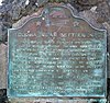
 Upload Photo | 544 | Fort Ter-Wer | Ter-Wer Riffle and Klamath Glen Rds. 41°30′36″N 123°59′19″W / 41.50992°N 123.98855°W / 41.50992; -123.98855 (Fort Ter-Wer) | Klamath | Also known as Fort Ter-Waw |
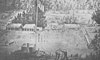
 | 649 | Tolowa Indian Settlements | 1886 Pebble Beach Dr. 41°45′25″N 124°13′17″W / 41.7569°N 124.2214°W / 41.7569; -124.2214 (Tolowa Indian Settlements) | Crescent City | |
 | 497 | S.S. Emidio | Beach Front Park and Picnic Area 41°45′02″N 124°11′48″W / 41.750544°N 124.196653°W / 41.750544; -124.196653 (S.S. Emidio) | Crescent City |
References
- ^ "California Historical Landmarks By County". Ohp.parks.ca.gov. Retrieved 2019-04-03.
See also
Wikimedia Commons has media related to California Historical Landmarks in Del Norte County, California.
- List of California Historical Landmarks
- National Register of Historic Places listings in Del Norte County, California
- v
- t
- e
National Park System | |||||||||||||||||
|---|---|---|---|---|---|---|---|---|---|---|---|---|---|---|---|---|---|
| |||||||||||||||||
National Forests and Grasslands | |||||||
|---|---|---|---|---|---|---|---|
| |||||||
|
| |||||||
| |||||||
|
|
- Heritage registers
- National Natural Landmarks


