Chūō-ku, Fukuoka
You can help expand this article with text translated from the corresponding article in Japanese. Click [show] for important translation instructions.
- Machine translation, like DeepL or Google Translate, is a useful starting point for translations, but translators must revise errors as necessary and confirm that the translation is accurate, rather than simply copy-pasting machine-translated text into the English Wikipedia.
- Consider adding a topic to this template: there are already 3,705 articles in the main category, and specifying
|topic=will aid in categorization. - Do not translate text that appears unreliable or low-quality. If possible, verify the text with references provided in the foreign-language article.
- You must provide copyright attribution in the edit summary accompanying your translation by providing an interlanguage link to the source of your translation. A model attribution edit summary is
Content in this edit is translated from the existing Japanese Wikipedia article at [[:ja:中央区 (福岡市)]]; see its history for attribution. - You may also add the template
{{Translated|ja|中央区 (福岡市)}}to the talk page. - For more guidance, see Wikipedia:Translation.
Ward in Kyushu, Japan
Chūō  Flag  Seal | |
|---|---|
 Location of Chūō Ward in Fukuoka | |
| Country | Japan |
| Region | Kyushu |
| Prefecture | Fukuoka |
| City | Fukuoka |
| Time zone | UTC+9 (Japan Standard Time) |

Chūō-ku (中央区) is one of the seven wards of Fukuoka city in Japan. The ward is located in the center of the city.
It includes Tenjin and Daimyō which are among the largest downtown areas in Kyūshū, Nagahama, which is known for its fish market, and Ōhori Park.
Main facilities
- Fukuoka Art Museum
- Fukuoka Municipal Zoo and Botanical Garden
- Fukuoka PayPay Dome
- Fukuoka Kyuden Kinen Gymnasium
- Acros Fukuoka
Gallery
-

-

-
 ACROS Fukuoka
 -
 Hilton Fukuoka Sea Hawk (left) and Fukuoka Yafuoku! Dome (right)
 -
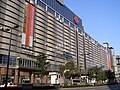 Tenjin
 -
 Fukuoka City Fish Market Center


See also
 Japan portal

- Kūkō Line (Fukuoka City Subway)
- Nanakuma Line
- Tenjin Omuta Line
- Love FM (Japan)
- Nakasu
- Kōki Hirota
- Fukuoka Japan Temple of the LDS Church
- New Otani Hotels
References
External links
![]() Media related to Chūō-ku, Fukuoka at Wikimedia Commons
Media related to Chūō-ku, Fukuoka at Wikimedia Commons
- v
- t
- e

| Wards |
|---|

| Wards |
|---|
| Authority control databases: Geographic |
|
|---|
33°35′21″N 130°23′35″E / 33.58917°N 130.39306°E / 33.58917; 130.39306
 | This Fukuoka Prefecture location article is a stub. You can help Wikipedia by expanding it. |
- v
- t
- e


