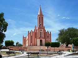
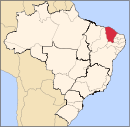
Chaval, Ceará
Municipality in Nordeste, Brazil
Chaval | |
|---|---|
Municipality | |
 | |
| Country |  Brazil Brazil |
| Region | Nordeste |
| State | Ceará |
| Mesoregion | Noroeste Cearense |
| Population (2020 [1]) | |
| • Total | 13,091 |
| Time zone | UTC−3 (BRT) |
Chaval is a municipality in the state of Ceará in the Northeast region of Brazil.[2][3][4][5]
The municipality contains part of the 313,800 hectares (775,000 acres) Delta do Parnaíba Environmental Protection Area, created in 1996.[6] The municipality also contains part of the 1,592,550 hectares (3,935,300 acres) Serra da Ibiapaba Environmental Protection Area, created in 1996.[7]
See also
References
- ^ IBGE 2020
- ^ "Divisão Territorial do Brasil" (in Portuguese). Divisão Territorial do Brasil e Limites Territoriais, Instituto Brasileiro de Geografia e Estatística (IBGE). July 1, 2008. Retrieved December 17, 2009.
- ^ "Estimativas da população para 1º de julho de 2009" (PDF) (in Portuguese). Estimativas de População, Instituto Brasileiro de Geografia e Estatística (IBGE). August 14, 2009. Archived from the original (PDF) on August 7, 2013. Retrieved December 17, 2009.
- ^ "Ranking decrescente do IDH-M dos municípios do Brasil" (in Portuguese). Atlas do Desenvolvimento Humano, Programa das Nações Unidas para o Desenvolvimento (PNUD). 2000. Archived from the original on October 3, 2009. Retrieved December 17, 2009.
- ^ "Produto Interno Bruto dos Municípios 2002-2005" (PDF) (in Portuguese). Instituto Brasileiro de Geografia e Estatística (IBGE). December 19, 2007. Archived from the original (PDF) on October 2, 2008. Retrieved December 17, 2009.
- ^ APA Delta do Parnaíba (Federal) (in Portuguese), ISA: Instituto Socioambiental, retrieved 2017-02-09
- ^ APA Serra da Ibiapaba (in Portuguese), ISA: Instituto Socioambiental, retrieved 2017-02-10
- v
- t
- e

Capital: Fortaleza
Centro-Sul Cearense | |||||||
|---|---|---|---|---|---|---|---|
| |||||||
Jaguaribe | |||||||||
|---|---|---|---|---|---|---|---|---|---|
| |||||||||
Metropolitana de Fortaleza | |||||
|---|---|---|---|---|---|
| |||||
Noroeste Cearense | |||||||||||||||
|---|---|---|---|---|---|---|---|---|---|---|---|---|---|---|---|
| |||||||||||||||
Norte Cearense | |||||||||||||||||
|---|---|---|---|---|---|---|---|---|---|---|---|---|---|---|---|---|---|
| |||||||||||||||||
Sertoes Cearenses | |||||||||
|---|---|---|---|---|---|---|---|---|---|
| |||||||||
Sul Cearense | |||||||||||
|---|---|---|---|---|---|---|---|---|---|---|---|
| |||||||||||
3°02′S 41°15′W / 3.033°S 41.250°W / -3.033; -41.250
 | This Ceará, Brazil location article is a stub. You can help Wikipedia by expanding it. |
- v
- t
- e


