Ching Wah Street
Street in Hong Kong
Ching Wah Street is a street in North Point in Hong Kong. The short, primarily residential, street runs from west to east, parallel to King's Road, at a higher elevation, just behind St. Jude's Church. It is the location of Kiangsu and Chekiang Primary School and Eng Yu Evangelistic Mission Hong Kong Church.
History
During the 1967 riots, a bomb exploded in Ching Wah Street, killing two young children. It was one of 15 bombs that exploded during the disturbances, which lasted from April to December that year.[1]
See also
-
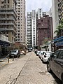
 Looking east on Ching Wah St. 2019
 -
 Looking west on Ching Wah St. 2019


References
- ^ Should history lessons in schools include details about Hong Kong’s 1967 riots?, SCMP, 30 October 2016
- v
- t
- e
- Aberdeen Street
- Arbuthnot Road
- Battery Path
- Belcher's Street
- Bonham Road
- Bonham Strand
- Bonham Strand West
- Bridges Street
- Caine Road
- Centre Street
- Chater Road
- Cochrane Street
- Conduit Road
- Connaught Road Central
 Connaught Road West
- Connaught Place
- Davis Street
- Des Voeux Road Central
- Des Voeux Road West
- Duddell Street
- Elgin Street
- Eastern Street
- Gage Street
- Garden Road
- Glenealy
- Gutzlaff Street
- Harcourt Road
- Hollywood Road
- Ice House Street
- Jubilee Street
- Ladder Street
- Lan Kwai Fong
- Lugard Road
- MacDonnell Road
- Magazine Gap Road
- Mosque Street
- Old Bailey Street
- On Lan Street
- Po Hing Fong
- Pottinger Street
- Peel Street
- Queen Victoria Street
- Queen's Road Central
- Queen's Road West
- Queensway
- Robinson Road
- Shelley Street
- Smithfield
- Staveley Street
- Tai Ping Shan Street
- Upper Albert Road
- Upper Lascar Row
- Water Street
- Wellington Street
- Western Street
- Wing Kut Street
- Wing On Street
- Wing Sing Street
- Wyndham Street

- Arsenal Street
- Amoy Street
- Blue Pool Road
 Canal Road
- Causeway Road
- Gloucester Road
- Gresson Street
- Hennessy Road
- Jaffe Road
- Jardine's Bazaar
- Johnston Road
- Lee Tung Street
- Lockhart Road
- Luard Road
- Oi Kwan Road
- Paterson Street
- Queen's Road East
- Stone Nullah Lane
- Stubbs Road
- Swatow Street
- Tai Yuen Street
- Thomson Road
- Victoria Park Road
- Yee Wo Street

22°17′20″N 114°11′53″E / 22.28902°N 114.19801°E / 22.28902; 114.19801
 | This Hong Kong road article is a stub. You can help Wikipedia by expanding it. |
- v
- t
- e
 | This Hong Kong Island location article is a stub. You can help Wikipedia by expanding it. |
- v
- t
- e


