County of Forty Mile No. 8
Municipal district in Alberta, Canada
Municipal district in Alberta, Canada
Seal

Welcome sign

Bow
Island
Island

Foremost

Burdett
Manyberries
Etzikom
Orion
Skiff
Aden
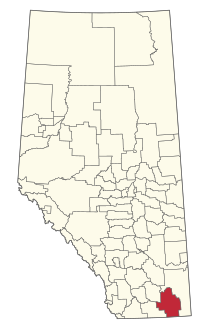
Location within Alberta
(2021)[2]
(2021)[2]
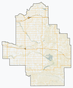
The County of Forty Mile No. 8 is a municipal district in south eastern Alberta, Canada. It is located in Census Division 1, southwest of Medicine Hat. Its municipal office is located in the Village of Foremost.

The County of Forty Mile is filled with several ghost towns such as Nemiskam, Orion, Conquerville, Altorado, Conrad, and the partially abandoned Etzikom.
Geography
Communities and localities
| The following urban municipalities are surrounded by the County of Forty Mile No. 8.[3]
| The following hamlets are located within the County of Forty Mile No. 8.[3]
|
The following localities are located within the County of Forty Mile No. 8.[4]
- Localities
|
|
- Other places
Demographics
In the 2021 Census of Population conducted by Statistics Canada, the County of Forty Mile No. 8 had a population of 3,471 living in 861 of its 994 total private dwellings, a change of -3.1% from its 2016 population of 3,581. With a land area of 7,163.61 km2 (2,765.89 sq mi), it had a population density of 0.5/km2 (1.3/sq mi) in 2021.[2]
In the 2016 Census of Population conducted by Statistics Canada, the County of Forty Mile No. 8 had a population of 3,581 living in 865 of its 968 total private dwellings, a 7.3% change from its 2011 population of 3,336. With a land area of 7,249.31 km2 (2,798.97 sq mi), it had a population density of 0.5/km2 (1.3/sq mi) in 2016.[5]
See also
- List of communities in Alberta
- List of municipal districts in Alberta
- List of ghost towns in Alberta
References
- ^ "Municipal Officials Search". Alberta Municipal Affairs. May 9, 2019. Retrieved October 1, 2021.
- ^ a b c "Population and dwelling counts: Canada, provinces and territories, and census subdivisions (municipalities)". Statistics Canada. February 9, 2022. Retrieved February 9, 2022.
- ^ a b "Specialized and Rural Municipalities and Their Communities" (PDF). Alberta Municipal Affairs. January 12, 2022. Retrieved January 21, 2022.
- ^ "Standard Geographical Classification (SGC) 2006, Economic Regions: 4801008 - Forty Mile County No. 8, geographical codes and localities, 2006". Statistics Canada. March 5, 2010. Archived from the original on May 25, 2013. Retrieved August 11, 2012.
- ^ "Population and dwelling counts, for Canada, provinces and territories, and census subdivisions (municipalities), 2016 and 2011 censuses – 100% data (Alberta)". Statistics Canada. February 8, 2017. Retrieved February 8, 2017.
External links
- Official website

Places adjacent to County of Forty Mile No. 8 | |
|---|---|


- v
- t
- e
Subdivisions of Alberta
service areas
municipalities
municipalities
- Crowsnest Pass, Municipality of
- Jasper, Municipality of
- Lac La Biche County
- Mackenzie County
- Strathcona County
- Wood Buffalo, Regional Municipality of
 Category
 Canada portal
 WikiProject


