Grade II* listed buildings in Carmarthenshire

Map all coordinates using OpenStreetMap
Download coordinates as:
- KML
- GPX (all coordinates)
- GPX (primary coordinates)
- GPX (secondary coordinates)
In the United Kingdom, the term listed building refers to a building or other structure officially designated as being of special architectural, historical, or cultural significance; Grade II* structures are those considered to be "particularly important buildings of more than special interest".[1] Listing was begun by a provision in the Town and Country Planning Act 1947. Once listed, strict limitations are imposed on the modifications allowed to a building's structure or fittings. In Wales, the authority for listing under the Planning (Listed Buildings and Conservation Areas) Act 1990[2] rests with Cadw.
Buildings
| Name | Location Grid Ref.[note 1] Geo-coordinates | Date Listed | Function | Notes | Reference Number | Image |
|---|---|---|---|---|---|---|
| Cenarth Bridge | Cenarth SN2691641580 52°02′44″N 4°31′31″W / 52.045510603562°N 4.5253346744034°W / 52.045510603562; -4.5253346744034 (Cenarth Bridge) | 23 June 1967 | Bridge | Crosses Afon Teifi between Cardigan and Newcastle Emlyn. Also in Ceredigion. | 9374 |  |
| St Luke's Church, Llanllwni | Llanllwni SN4734441299 52°02′56″N 4°13′39″W / 52.04900496°N 4.2275870860976°W / 52.04900496; -4.2275870860976 (St Luke's Church, Llanllwni) | 23 June 1967 | Church | In an isolated position away from Llanllwni village and on an elevated site directly above Afon Teifi. | 9378 |  |
| Pont Cothi | Abergorlech SN5847333584 51°58′58″N 4°03′44″W / 51.982647858451°N 4.0622209383088°W / 51.982647858451; -4.0622209383088 (Pont Cothi) | 7 August 1966 | Bridge | Spanning the Afon Cothi in the centre of the village and carrying a minor road immediately S of its junction with the B4310. Additional reference numbers: Coflein 23996 | 9380 |  |
| Paxton's Tower | Llanarthney SN5409719147 51°51′06″N 4°07′11″W / 51.851802258629°N 4.1197734847521°W / 51.851802258629; -4.1197734847521 (Paxton's Tower) | 12 March 1951 | Tower | On the summit of a high hill 1km SE of Llanarthney village, making an impressive and conspicuous landmark for miles around. | 9384 |  See more images |
| Plas Llanstephan | Llansteffan SN3492110466 51°46′06″N 4°23′38″W / 51.768465191051°N 4.3938043643346°W / 51.768465191051; -4.3938043643346 (Plas Llanstephan) | 12 March 1951 | Country house | At the end of a private access road leading S from Llansteffan village. | 9385 |  |
| Cwmgwili | Bronwydd SN4234823255 51°53′08″N 4°17′32″W / 51.885504785975°N 4.2920916404795°W / 51.885504785975; -4.2920916404795 (Cwmgwili) | 30 November 1966 | House | Set in its own grounds approximately 2.5km NW of Abergwili. Additional reference numbers: Coflein 17269 | 9387 |  Upload Photo |
| St Cynwyl's Church, Cynwyl Elfed | Cynwyl Elfed SN3737227507 51°55′20″N 4°21′59″W / 51.922268108283°N 4.366334817536°W / 51.922268108283; -4.366334817536 (St Cynwyl's Church, Cynwyl Elfed) | 30 November 1966 | Church | Near the centre of Cynwyl Elfed village NE of Pont Cynwyl just off the A484. | 9388 |  |
| St David's Church, Llanarthney (also known as Church of St Arthneu or St Arthney). | Llanarthney SN5344220262 51°51′42″N 4°07′47″W / 51.861648171091°N 4.1297495210524°W / 51.861648171091; -4.1297495210524 (St David's Church, Llanarthney (also known as Church of St Arthneu or St Arthney).) | 30 November 1966 | Church | In centre of the village of Llanarthney. Stone-walled graveyard with lychgate [separately listed]. Graveyard extended to W. Numerous tombstones of a locally favoured tapering obelisk type; several enclosures with cast-iron railings. | 9390 |  See more images |
| Pont Llandeilo-yr-ynys | Llanarthney SN4931820280 51°51′39″N 4°11′23″W / 51.860708827894°N 4.1896001946511°W / 51.860708827894; -4.1896001946511 (Pont Llandeilo-yr-ynys) | 30 November 1966 | Bridge | Across River Towy 8km east of Carmarthen. Also in Llanegwad. | 9391 | 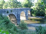 |
| Capel Bigawdin | Llanddarog SN5115314712 51°48′40″N 4°09′38″W / 51.811176739458°N 4.1605761997521°W / 51.811176739458; -4.1605761997521 (Capel Bigawdin) | 30 November 1966 | Chapel | Attached to a field wall S of Wern-las Farm, approximately 2km SE of Llanddarog village. | 9395 | Upload Photo |
| St Cyndeyrn's Church | Llangyndeyrn SN4562113985 51°48′11″N 4°14′26″W / 51.80314123722°N 4.2404340655234°W / 51.80314123722; -4.2404340655234 (St Cyndeyrn's Church) | 30 November 1966 | Church | In a round churchyard in the centre of the village. | 9399 | 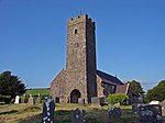 See more images |
| St Cynin's Church | Llangynin SN2539618043 51°50′01″N 4°32′08″W / 51.833625534189°N 4.5355208296816°W / 51.833625534189; -4.5355208296816 (St Cynin's Church) | 30 November 1966 | Church | In an isolated position on a minor road 2 km S of the centre of the village of Llangynin. | 9401 |  |
| St Ystyffan's Church | Llansteffan SN3500910708 51°46′14″N 4°23′34″W / 51.770665130334°N 4.3926452468704°W / 51.770665130334; -4.3926452468704 (St Ystyffan's Church) | 30 November 1966 | Church | Within a stone walled cemetery, on the SW corner of the junction of High Street and Church Street. | 9404 | 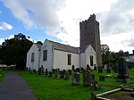 See more images |
| Vale View, Llansteffan | Llansteffan SN3493610704 51°46′14″N 4°23′37″W / 51.770607619371°N 4.3937003483724°W / 51.770607619371; -4.3937003483724 (Vale View, Llansteffan) | 30 November 1966 | House | Set slightly back from the street, on the S side of the road, within a small railed forecourt, immediately W of Brook Cottages. | 9406 | Upload Photo |
| St Mary Magdalene's Parish Church, St Clears | St Clears SN2815115739 51°48′50″N 4°29′40″W / 51.813786986612°N 4.4944333496493°W / 51.813786986612; -4.4944333496493 (St Mary Magdalene's Parish Church, St Clears) | 30 November 1966 | Church | Within a cemetery behind the street, reached via a lych-gate opposite the Town Hall. | 9409 |  |
| Rhydarwen | Llanarthney SN5588019469 51°51′19″N 4°05′39″W / 51.855159697407°N 4.0940392716704°W / 51.855159697407; -4.0940392716704 (Rhydarwen) | 13 December 1971 | Farmhouse | At north of the B4300, 2?km east of the village of Llanarthney. Small farmyard at west. Stone wall facing the farmyard and to the roadside. Additional reference numbers: Coflein 17768 | 9417 | Upload Photo |
| Carmarthen Guildhall | Carmarthen SN4121220020 51°51′22″N 4°18′26″W / 51.856119725629°N 4.3070947910891°W / 51.856119725629; -4.3070947910891 (Carmarthen Guildhall) | 18 August 1954 | Guildhall | At upper end of Guildhall Square. | 9450 |  See more images |
| No 51 King Street including near-detached rear wing | Carmarthen SN4134220111 51°51′25″N 4°18′19″W / 51.856974301465°N 4.3052505761105°W / 51.856974301465; -4.3052505761105 (No 51 King Street including near-detached rear wing) | 19 May 1981 | Opposite Post Office. | 9471 | 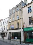 | |
| Capel Heol Awst, Carmarthen | Carmarthen SN4090620031 51°51′22″N 4°18′42″W / 51.856131172848°N 4.3115392366242°W / 51.856131172848; -4.3115392366242 (Capel Heol Awst, Carmarthen) | 19 May 1981 | Chapel | Set back in railed forecourt roughly midway along Lammas Street. | 9488 |  |
| St Mary's Church, Llanllwch | Llanllwch SN3858318782 51°50′39″N 4°20′41″W / 51.844242175599°N 4.3446566442511°W / 51.844242175599; -4.3446566442511 (St Mary's Church, Llanllwch) | 19 May 1981 | Church | In centre of Llanllwch village. | 9495 | 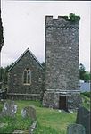 See more images |
| 2 Quay Street | Carmarthen SN4120819988 51°51′21″N 4°18′26″W / 51.85583110962°N 4.3071381106852°W / 51.85583110962; -4.3071381106852 (2 Quay Street) | 18 August 1954 | House | 5m SW of junction with St Mary's Street. | 9556 |  |
| Ty Gelli Aur/Golden Grove House, with steps and railings | Carmarthen SN4117319928 51°51′19″N 4°18′27″W / 51.855282109037°N 4.3076182909129°W / 51.855282109037; -4.3076182909129 (Ty Gelli Aur/Golden Grove House, with steps and railings) | 18 August 1954 | House | 15m NE of junction with Little Bridge Street. | 9561 |  |
| St Martin's Parish Church, Laugharne | Laugharne, Laugharne Township SN3021311437 51°46′33″N 4°27′45″W / 51.775775538091°N 4.4624427020803°W / 51.775775538091; -4.4624427020803 (St Martin's Parish Church, Laugharne) | 30 November 1966 | Church | 9623 | 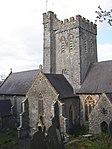 See more images | |
| Great House, Laugharne | Laugharne Township SN3015011061 51°46′21″N 4°27′47″W / 51.772378876854°N 4.4631709573224°W / 51.772378876854; -4.4631709573224 (Great House, Laugharne) | 30 November 1966 | House | 9650 |  | |
| Castle House, Laugharne | Laugharne Township SN3021210813 51°46′13″N 4°27′44″W / 51.770170027813°N 4.4621519360305°W / 51.770170027813; -4.4621519360305 (Castle House, Laugharne) | 30 November 1966 | House | Pink-painted stucco walls. Market Street, opposite Town Hall | 9657 |  |
| Laugharne Town Hall | Laugharne Township SN3020610838 51°46′13″N 4°27′44″W / 51.770392770583°N 4.4622510356178°W / 51.770392770583; -4.4622510356178 (Laugharne Town Hall) | 12 March 1951 | Town Hall | 9659 |  See more images | |
| Newcastle Emlyn Bridge | Newcastle Emlyn SN3091340861 52°02′25″N 4°28′00″W / 52.040289510935°N 4.4667536009472°W / 52.040289510935; -4.4667536009472 (Newcastle Emlyn Bridge) | 21 September 1964 | Bridge | 9686 |  | |
| The Bunch of Grapes Inn | Newcastle Emlyn SN3087440748 52°02′21″N 4°28′02″W / 52.039262587104°N 4.4672657398614°W / 52.039262587104; -4.4672657398614 (The Bunch of Grapes Inn) | 8 May 1991 | Inn | 9692 |  | |
| Felin Wen (White Mill) | Abergwili SN4625521442 51°52′13″N 4°14′04″W / 51.87031069061°N 4.2345621721395°W / 51.87031069061; -4.2345621721395 (Felin Wen (White Mill)) | 6 April 1974 | Mill | On the S side of the road through White Mill hamlet, opposite a junction with a minor road to Capel Gwyn. | 9720 | Upload Photo |
| Cenarth Mill | Cenarth SN2700941575 52°02′44″N 4°31′26″W / 52.045494808549°N 4.5239774371234°W / 52.045494808549; -4.5239774371234 (Cenarth Mill) | 1 August 1975 | Mill | On riverside, down track 100 m NE of the White Hart Inn. | 9723 |  See more images |
| Gilfach-y-Berthog | Abergwili SN4813222958 51°53′04″N 4°12′29″W / 51.884446168733°N 4.2079881131739°W / 51.884446168733; -4.2079881131739 (Gilfach-y-Berthog) | 24 September 1991 | House | Approximately 2.5km NE of Whitemill, reached by farm road on the N side of a minor road 0.75km W of Llanfihangel-uwch-gwili. Additional reference numbers: Coflein 17364 | 9738 | Upload Photo |
| English Baptist Church, Carmarthen | Carmarthen SN4106720098 51°51′24″N 4°18′33″W / 51.856779064039°N 4.3092343134671°W / 51.856779064039; -4.3092343134671 (English Baptist Church, Carmarthen) | 19 May 1981 | Church | Set back from the street in paved forecourt, between 7 and 8 Lammas Street | 9741 |  See more images |
| Capel y Graig including attached schoolroom and forecourt railings | Trelech SN2817830337 51°56′42″N 4°30′05″W / 51.944918882524°N 4.5013132712795°W / 51.944918882524; -4.5013132712795 (Capel y Graig including attached schoolroom and forecourt railings) | 16 December 1993 | Chapel | Just W of the road junction in the centre of Trelech village. | 9758 |  |
| Derwydd Mansion | Llandybie SN6126117836 51°50′31″N 4°00′55″W / 51.841853391024°N 4.0153043514728°W / 51.841853391024; -4.0153043514728 (Derwydd Mansion) | 26 November 1951 | House | In private grounds about 2km north-north-west of Llandybie village. | 10903 | Upload Photo |
| Pantycelyn Farmhouse | Llanfair ar y Bryn SN8199935402 52°00′16″N 3°43′14″W / 52.004492831684°N 3.7204635314481°W / 52.004492831684; -3.7204635314481 (Pantycelyn Farmhouse) | 26 November 1951 | Farmhouse | Down a lane 300 m E of the centre of Pentre-ty-gwyn village. | 10905 |  See more images |
| Henllys | Cilycwm SN7551036626 52°00′51″N 3°48′55″W / 52.014071772772°N 3.8153910488824°W / 52.014071772772; -3.8153910488824 (Henllys) | 7 August 1966 | House | About 1 km NNW of Dolauhirion Bridge, approached from N via drive off road to Siloh, 250 m W of junction with road to Cilycwm. | 10907 |  |
| Parish church of St Cynwyl, Caeo | Cynwyl Gaeo SN6750739907 52°02′30″N 3°56′00″W / 52.041696368439°N 3.9332066433071°W / 52.041696368439; -3.9332066433071 (Parish church of St Cynwyl, Caeo) | 7 August 1966 | Church | 10908 | 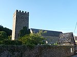 | |
| Cwrt Bryn y Beirdd | Dyffryn Cennen SN6630718093 51°50′43″N 3°56′32″W / 51.845396461154°N 3.9422038111173°W / 51.845396461154; -3.9422038111173 (Cwrt Bryn y Beirdd) | 7 August 1966 | Farmhouse | SE of Trap, reached by drive running E from crossroads about 1 km S of Trap. Additional reference numbers: Coflein 17280 | 10909 | Upload Photo |
| St Simon and St Jude's Church, Llanddeusant | Llanddeusant SN7769424533 51°54′21″N 3°46′45″W / 51.905886020171°N 3.7792747790155°W / 51.905886020171; -3.7792747790155 (St Simon and St Jude's Church, Llanddeusant) | 7 August 1966 | Church | On ridge above upper Sawdde valley 2.5 km E of Twynllanan on road to Llyn y Fan Fach. | 10914 |  |
| St Tybie's Church | Llandybie SN6182315550 51°49′17″N 4°00′22″W / 51.821452407457°N 4.0062385591312°W / 51.821452407457; -4.0062385591312 (St Tybie's Church) | 7 August 1966 | Church | At the centre of Llandybie village. Large stone-walled graveyard to north side (recent parts walled in concrete blocks). High wall with steps and iron gates from the street at west and south; stile beside south gate. Church House at south-east. | 10915 |  See more images |
| Cil-yr-ychen Lime Kilns | Llandybie SN6166416761 51°49′56″N 4°00′33″W / 51.832294308889°N 4.0090282625928°W / 51.832294308889; -4.0090282625928 (Cil-yr-ychen Lime Kilns) | 7 August 1966 | Lime Kilns | Prominently sited 200m to the west of Llandeilo Road, about 1? km north of Llandybie village. | 10916 |  |
| Pont Llandeilo-yr-ynys | Llanegwad SN4932620300 51°51′39″N 4°11′22″W / 51.860890679692°N 4.1894928386763°W / 51.860890679692; -4.1894928386763 (Pont Llandeilo-yr-ynys) | 7 August 1966 | Bridge | Spanning the Afon Tywi approximately 1.4km S of Nantgaredig. Also known as Rhynnws Bridge, Pont-newydd or Newbridge. Also in Llanarthney. | 10921 | |
| Cynghordy Viaduct | Llanfair ar y Bryn SN8083541752 52°03′41″N 3°44′23″W / 52.06130786473°N 3.7396265620332°W / 52.06130786473; -3.7396265620332 (Cynghordy Viaduct) | 7 August 1966 | Viaduct | Approximately 1.5km N of Cynghordy crossing the valley of the Afon Bran. | 10922 |  See more images |
| Golden Grove Mansion | Llanfihangel Aberbythych SN5971019857 51°51′35″N 4°02′19″W / 51.859624093518°N 4.038623652229°W / 51.859624093518; -4.038623652229 (Golden Grove Mansion) | 7 August 1966 | Country house | In park landscape to the south of, and overlooking, the Towy valley, 4 km south-west of Llandeilo. Two gate-lodges to the B4300 at north. A third, which is at the present principal park entrance, is in the village of Golden Grove. | 10926 |  See more images |
| St Egwad's Church | Llanfynydd SN5584027618 51°55′42″N 4°05′53″W / 51.928366601131°N 4.0980282999683°W / 51.928366601131; -4.0980282999683 (St Egwad's Church) | 7 August 1966 | In a round churchyard in the centre of the village. | 10927 |  | |
| Pont Cothi | Abergorlech, Llanfynydd SN5847233572 51°58′57″N 4°03′44″W / 51.982539784677°N 4.0622305353065°W / 51.982539784677; -4.0622305353065 (Pont Cothi) | 7 August 1966 | Bridge | Spanning the Afon Cothi in the centre of Abergorlech, on the border between Llanfynydd and Llanfihangel Rhos y Corn communities. | 10928 |  |
| St Cathen's Church | Llangathen SN5845022142 51°52′47″N 4°03′28″W / 51.87983606238°N 4.0578452936604°W / 51.87983606238; -4.0578452936604 (St Cathen's Church) | 7 August 1966 | Church | In a large churchyard occupying a high position at the S end of the village of Llangathen. | 10929 |  See more images |
| Llethr Cadfan Farmhouse including former 'granary' building | Llangathen SN5781623135 51°53′19″N 4°04′03″W / 51.888596490385°N 4.06745906039°W / 51.888596490385; -4.06745906039 (Llethr Cadfan Farmhouse including former 'granary' building) | 7 August 1966 | Set back on the W side of a minor road 0.5km N of the crossroads with the A40 in Broad Oak. | 10932 | Upload Photo | |
| Saint Cadoc's Church, Llangadog | Llangadog SN7062328456 51°56′22″N 3°53′01″W / 51.939537304581°N 3.8834773175928°W / 51.939537304581; -3.8834773175928 (Saint Cadoc's Church, Llangadog) | 7 August 1966 | Church | Towards the upper end of Church Street, in large churchyard with stone boundary wall. | 10936 |  |
| Church House, Llangadog | Llangadog SN7064228414 51°56′21″N 3°52′59″W / 51.939164323294°N 3.8831852735735°W / 51.939164323294; -3.8831852735735 (Church House, Llangadog) | 7 August 1966 | House | On E side of street, just S of churchyard. | 10937 |  |
| Red Lion Hotel, Llangadog | Llangadog SN7065028350 51°56′19″N 3°52′59″W / 51.938591088807°N 3.8830448762738°W / 51.938591088807; -3.8830448762738 (Red Lion Hotel, Llangadog) | 7 August 1966 | Inn | Situated prominently in centre of Church Street. | 10940 | 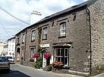 |
| Plas Glansevin | Llangadog SN7305028635 51°56′30″N 3°50′54″W / 51.941706020593°N 3.8482576090297°W / 51.941706020593; -3.8482576090297 (Plas Glansevin) | 7 August 1966 | Hall | About 2 km E of Llangadog near the River Bran. | 10943 | Upload Photo |
| Bont-ar-Towy | Llansadwrn SN6951028620 51°56′27″N 3°53′59″W / 51.94075052397°N 3.8997209718438°W / 51.94075052397; -3.8997209718438 (Bont-ar-Towy) | 7 August 1966 | Bridge | Bridge over River Towy on A4069 road to Llangadog, just E of A40. | 10947 | Upload Photo |
| Castle Green including front railings and gate | Llansawel SN6202836398 52°00′32″N 4°00′42″W / 52.008828308714°N 4.0116241563958°W / 52.008828308714; -4.0116241563958 (Castle Green including front railings and gate) | 7 August 1966 | 10950 |  | ||
| The Dairy, Edwinsford | Llansawel SN6317434668 51°59′37″N 3°59′39″W / 51.99356820037°N 3.9942470346317°W / 51.99356820037; -3.9942470346317 (The Dairy, Edwinsford) | 7 August 1966 | 10952 | Upload Photo | ||
| Edwinsford Home Farm, Edwinsford | Llansawel SN6316934688 51°59′37″N 3°59′40″W / 51.993746670366°N 3.9943277986377°W / 51.993746670366; -3.9943277986377 (Edwinsford Home Farm, Edwinsford) | 7 August 1966 | 10953 | Upload Photo | ||
| Neuadd Fawr | Llanwrda SN7138031666 51°58′07″N 3°52′25″W / 51.9685580358°N 3.8736739923995°W / 51.9685580358; -3.8736739923995 (Neuadd Fawr) | 7 August 1966 | In village on E bank of the Afon Dulais, with short approach just NE of Pont y Neuadd. | 10956 | Upload Photo | |
| Llandovery Castle | Llandovery SN7675734226 51°59′34″N 3°47′47″W / 51.992783695612°N 3.7963664297911°W / 51.992783695612; -3.7963664297911 (Llandovery Castle) | 3 August 1966 | On prominent natural outcrop overlooking Afon Bran, on SE of main car park. | 10965 |  See more images | |
| Ty-Ficar Pritchard | Llandovery SN7705134355 51°59′38″N 3°47′32″W / 51.994008225155°N 3.7921330872222°W / 51.994008225155; -3.7921330872222 (Ty-Ficar Pritchard) | 3 August 1966 | On street line 100 m W of Pont a'r Fran. | 10984 |  | |
| St Dingat's Church, Llandovery | Llandovery SN7637634086 51°59′29″N 3°48′07″W / 51.991440768211°N 3.8018619536735°W / 51.991440768211; -3.8018619536735 (St Dingat's Church, Llandovery) | 3 August 1966 | Church | In large churchyard towards SW edge of town. | 10991 |  |
| Tabernacle Chapel, Llandovery | Llandovery SN7687734423 51°59′40″N 3°47′41″W / 51.994580662606°N 3.7946904476317°W / 51.994580662606; -3.7946904476317 (Tabernacle Chapel, Llandovery) | 26 February 1981 | Chapel | Set back from road in own courtyard, c30m from junction with Water Street. | 11018 | Upload Photo |
| Llandeilo Bridge | Llandeilo SN6275922009 51°52′47″N 3°59′43″W / 51.879720644303°N 3.9952329824484°W / 51.879720644303; -3.9952329824484 (Llandeilo Bridge) | 14 March 1966 | Bridge | Spanning the River Towy and linking Llandeilo with Ffairfach; partly in Dyffryn Cennen community | 11040 |  |
| Plas Dinefwr | Llandeilo SN6143222529 51°53′03″N 4°00′53″W / 51.884064083226°N 4.0147076418783°W / 51.884064083226; -4.0147076418783 (Plas Dinefwr) | 7 August 1966 | Hall | 11098 |  See more images | |
| Summer house at Plas Dinefwr | Llandeilo SN6140922502 51°53′02″N 4°00′54″W / 51.883815750775°N 4.0150307395384°W / 51.883815750775; -4.0150307395384 (Summer house at Plas Dinefwr) | 7 August 1966 | Summerhouse | 11099 | 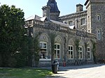 | |
| Inner courtyard ranges at Dynevor Castle | Llandeilo SN6141822474 51°53′01″N 4°00′54″W / 51.883566404871°N 4.0148888097126°W / 51.883566404871; -4.0148888097126 (Inner courtyard ranges at Dynevor Castle) | 7 August 1966 | Castle | 11102 |  | |
| Outer courtyard ranges at Dynevor Castle | Llandeilo SN6142722434 51°53′00″N 4°00′53″W / 51.883209235296°N 4.0147420587119°W / 51.883209235296; -4.0147420587119 (Outer courtyard ranges at Dynevor Castle) | 7 August 1966 | Castle | 11103 |  | |
| Farmhouse at Gelli Cefn y Rhos, Cwmdu | Gelli Cefn y Rhos, Talley SN6400531311 51°57′49″N 3°58′51″W / 51.963609034344°N 3.9808201463996°W / 51.963609034344; -3.9808201463996 (Farmhouse at Gelli Cefn y Rhos, Cwmdu) | 28 April 1975 | Farmhouse | 11129 | Upload Photo | |
| St Michael's Church, Talley | Talley SN6325432824 51°58′37″N 3°59′32″W / 51.97701914035°N 3.9923469285898°W / 51.97701914035; -3.9923469285898 (St Michael's Church, Talley) | 7 August 1966 | Church | 11151 |  See more images | |
| Aberglasney | Llangathen SN5813722136 51°52′47″N 4°03′45″W / 51.879702427436°N 4.0623869019525°W / 51.879702427436; -4.0623869019525 (Aberglasney) | 26 November 1951 | Country house | Approximately 300m W of Llangathen church, set in its own grounds on the W side of a minor road between Llangathen and the A40 at Broad Oak. | 11153 |  See more images |
| Arcaded terrace walks enclosing walled garden at Aberglasney | Llangathen SN5809922108 51°52′46″N 4°03′47″W / 51.879441155716°N 4.0629270562391°W / 51.879441155716; -4.0629270562391 (Arcaded terrace walks enclosing walled garden at Aberglasney) | 20 September 1990 | On the W side of the house. | 11154 | 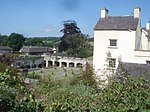 | |
| Gatehouse at Aberglasney | Llangathen SN5810122161 51°52′48″N 4°03′47″W / 51.879917872144°N 4.0629198276227°W / 51.879917872144; -4.0629198276227 (Gatehouse at Aberglasney) | 20 September 1990 | Gatehouse | On the NW side of the house. | 11156 |  |
| Old Bethel Chapel | Cwmamman SN6815114400 51°48′46″N 3°54′51″W / 51.812650966552°N 3.9140432524697°W / 51.812650966552; -3.9140432524697 (Old Bethel Chapel) | 9 March 1991 | Chapel | Located on a remote upland plateau on the N side of the Amman Valley approximately 1 km from the A474. Reached along short lane off mountain road at the lower end of a walled and gated burial ground. | 11168 |  |
| Court Henry | Llangathen SN5566422560 51°52′58″N 4°05′54″W / 51.882875892942°N 4.0984661344754°W / 51.882875892942; -4.0984661344754 (Court Henry) | 7 August 1966 | House | In its own grounds on the W side of a minor road approximately 0.6km N of the A40 at its junction with the B4297. | 11176 | Upload Photo |
| Erryd | Cilycwm SN7540438095 52°01′38″N 3°49′03″W / 52.027248542868°N 3.8174699248949°W / 52.027248542868; -3.8174699248949 (Erryd) | 29 March 1993 | House | 2km S of Cilycwm on W side of Towy, approached by short drive E from road to Llandovery. | 11179 | Upload Photo |
| Aberdeunant | Llansadwrn SN6714730764 51°57′34″N 3°56′06″W / 51.959455299117°N 3.9349051568129°W / 51.959455299117; -3.9349051568129 (Aberdeunant) | 5 July 1993 | House | 400 m up lane running N from Taliaris to Llansadwrn road, 3 km ENE of junction with B4302. | 11180 | Upload Photo |
| The Raby Furnace | Llanelli Rural SN5039101507 51°41′32″N 4°09′57″W / 51.6923311091°N 4.1659355144°W / 51.6923311091; -4.1659355144 (The Raby Furnace) | 3 March 1966 | Furnace | 100 m north of Stradey Park Hotel at the east side of a culverted stream in a deep valley beside the B4309. | 11870 | Upload Photo |
| St Non's Church | Llannon SN5397408475 51°45′21″N 4°07′01″W / 51.75588405055°N 4.1170593030287°W / 51.75588405055; -4.1170593030287 (St Non's Church) | 3 March 1966 | Church | In the centre of the village in a churchyard with stone wall and iron railings and gates to road at west; stone wall to minor road at north. | 11871 |  |
| St Illtyd's Church, Pembrey | Pembrey, Pembrey and Burry Port SN4285401217 51°41′16″N 4°16′29″W / 51.687661425534°N 4.2747591365846°W / 51.687661425534; -4.2747591365846 (St Illtyd's Church, Pembrey) | 3 March 1966 | Church | In a large churchyard on the E side of the main square, and immediately S of the A484. Additional reference numbers: Coflein 101623 | 11872 | 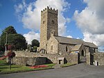 See more images |
| Pont Spwdwr (Spudder's Bridge) | Trimsaran SN4339205879 51°43′47″N 4°16′09″W / 51.729695844413°N 4.2690786258661°W / 51.729695844413; -4.2690786258661 (Pont Spwdwr (Spudder's Bridge)) | 3 March 1966 | Bridge | Approximately 2km NW of Trimsaran village centre, by-passed by and set back from the modern road. | 11875 |  |
| Kidwelly town gate | Kidwelly SN4072406941 51°44′19″N 4°18′29″W / 51.738483047107°N 4.3081638444587°W / 51.738483047107; -4.3081638444587 (Kidwelly town gate) | 12 May 1963 | Town gate | At SW end of Castle Street, 130 m WSW of Kidwelly Castle. | 11877 |  See more images |
| Dovecote NW of Coleman Farm | Kidwelly SN3964107187 51°44′25″N 4°19′26″W / 51.74038339665°N 4.3239482605488°W / 51.74038339665; -4.3239482605488 (Dovecote NW of Coleman Farm) | 12 May 1963 | Dovecote | In patch of scrub woodland at intersection of four fields on hillside 300 m NW of Coleman Farm, which is on the lower road from Kidwelly to Ferryside via St Ishmael. Additional reference numbers: Coflein 31585 | 11879 |  |
| Stradey Castle | Llanelli Rural SN4910901537 51°41′32″N 4°11′04″W / 51.692256687964°N 4.1844819029615°W / 51.692256687964; -4.1844819029615 (Stradey Castle) | 9 February 1986 | House | Entered by private drive from the B4308. House on terraced site with main basement area including external stairs to north-west. Landscaped parkland with woods to north. Terrace retaining-wall to south front with crenellated outer turrets. | 11884 | Upload Photo |
| St Ellyw's Parish Church, Llanelli | Llanelli SN5069900539 51°41′01″N 4°09′40″W / 51.68371607139°N 4.1610684110576°W / 51.68371607139; -4.1610684110576 (St Ellyw's Parish Church, Llanelli) | 30 November 1964 | Church | 11888 |  See more images | |
| Tabernacle Chapel, including forecourt railings | Llanelli SN5051000394 51°40′57″N 4°09′49″W / 51.682362879793°N 4.1637380928545°W / 51.682362879793; -4.1637380928545 (Tabernacle Chapel, including forecourt railings) | 3 December 1992 | Chapel | 11900 |  See more images | |
| Carreg Cennen House | Dyffryn Cennen SN6531319282 51°51′21″N 3°57′26″W / 51.855840972599°N 3.9570880440175°W / 51.855840972599; -3.9570880440175 (Carreg Cennen House) | 18 April 1991 | About 0.5 km N of Trap, approached by avenue of limes from gates set in stone flanking walls on E side of road to Llandeilo. | 15616 | Upload Photo | |
| St Michael's Church, Llanfihangel ar Arth | Llanfihangel ar Arth SN4560839922 52°02′10″N 4°15′08″W / 52.036152421799°N 4.2522597286937°W / 52.036152421799; -4.2522597286937 (St Michael's Church, Llanfihangel ar Arth) | 23 June 1967 | At the N end of Llanfihangel ar Arth village, set in a walled churchyard overlooking the Teifi valley. | 15631 |  | |
| Edwinsford, Llansawel | Talley SN6312034581 51°59′34″N 3°59′42″W / 51.992773148818°N 3.9949982539417°W / 51.992773148818; -3.9949982539417 (Edwinsford, Llansawel) | 26 November 1951 | 15766 | Upload Photo | ||
| Pont Newydd | Cilycwm SN7581538432 52°01′49″N 3°48′42″W / 52.030369230314°N 3.8116050488987°W / 52.030369230314; -3.8116050488987 (Pont Newydd) | 29 November 1995 | Bridge | 1.5 km S of Cilycwm on road to Llandovery. | 16986 |  |
| The Coach house at Henllys | Cilycwm SN7549236667 52°00′52″N 3°48′56″W / 52.014436157771°N 3.8156681093409°W / 52.014436157771; -3.8156681093409 (The Coach house at Henllys) | 29 November 1995 | 17000 | Upload Photo | ||
| Tinhouse, Old Castle Tinplate Works | Llanelli SS5049499006 51°40′12″N 4°09′48″W / 51.669887774052°N 4.1633747377951°W / 51.669887774052; -4.1633747377951 (Tinhouse, Old Castle Tinplate Works) | 31 July 1997 | On the western side of Llanelli, S of the A484. | 18657 | Upload Photo | |
| Church of St Margaret of Antioch, Pendine | Pendine SN2287308787 51°44′59″N 4°34′03″W / 51.749692075899°N 4.5673704679674°W / 51.749692075899; -4.5673704679674 (Church of St Margaret of Antioch, Pendine) | 31 October 1997 | Church | About 1 km above Dolwen Point, in churchyard near junction of B4314 and minor road to Marros. | 19014 |  |
| Capel Brynseion | Cwmamman SN6754913574 51°48′18″N 3°55′21″W / 51.80508597723°N 3.922454769654°W / 51.80508597723; -3.922454769654 (Capel Brynseion) | 1 September 1998 | Chapel | In the centre of Glanamman, 25m S of A474 on the E side of High Street. | 19220 | 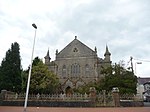 |
| Cold-roll Engine-house at former Kidwelly Tinplate Works | Kidwelly SN4219107937 51°44′52″N 4°17′15″W / 51.747847072394°N 4.2873880628424°W / 51.747847072394; -4.2873880628424 (Cold-roll Engine-house at former Kidwelly Tinplate Works) | 28 July 1998 | At NE end of Kidwelly Industrial Museum site, which is 2 km NE of Kidwelly, in Gwendraeth Fach valley. | 20197 | Upload Photo | |
| Felinfoel Brewery | Llanelli Rural SN5176002052 51°41′51″N 4°08′47″W / 51.697591896982°N 4.1463757323335°W / 51.697591896982; -4.1463757323335 (Felinfoel Brewery) | 16 October 1998 | Brewery | Prominently sited at E side of the A 476 in Felinfoel, Llanelli. Brewery yard to south and to rear. Office building to south. | 20532 |  |
| Hoffmann Kiln of Eclipse Brickworks | Llanelli Rural SN5010305290 51°43′34″N 4°10′18″W / 51.726243056079°N 4.1717270288568°W / 51.726243056079; -4.1717270288568 (Hoffmann Kiln of Eclipse Brickworks) | 16 October 1998 | W side of the former Llanelli and Mynydd Mawr Railway, 1/2 km SE of Horeb. Site of siding with a passing loop and remains of brickwork loading platform at E. Site of moulding & drying shed and ruin of engine house (for tramway to claypit) at E. | 20537 | Upload Photo | |
| Church of St Michael and all Angels, Llanelli | Llanelli Rural SN5274301009 51°41′19″N 4°07′54″W / 51.688480020243°N 4.1317222455764°W / 51.688480020243; -4.1317222455764 (Church of St Michael and all Angels, Llanelli) | 16 October 1998 | At the south side of Bryngwyn Road, Dafen. Stone wall to street and to west side; timber war-memorial lychgate. | 20545 |  | |
| Llandeilo Bridge | Dyffryn Cennen SN6275421989 51°52′46″N 3°59′43″W / 51.879539702895°N 3.9952976149137°W / 51.879539702895; -3.9952976149137 (Llandeilo Bridge) | 14 March 1966 | Bridge | Spanning the River Towy and linking Llandeilo with Ffairfach; partly in Llandeilo community. | 20900C | |
| Cross Hands Public Hall | Cross Hands SN5595713059 51°47′51″N 4°05′25″W / 51.797586138256°N 4.0902531162903°W / 51.797586138256; -4.0902531162903 (Cross Hands Public Hall) | 1 December 1999 | 500m north-west of Crosshands crossroads | 21086 | Upload Photo | |
| Cefnarthen Chapel | Llanfair-ar-y-Bryn SN8393535059 52°00′07″N 3°41′32″W / 52.001819343299°N 3.6921568544041°W / 52.001819343299; -3.6921568544041 (Cefnarthen Chapel) | 25 February 1999 | chapel | At the end of a lane off a minor road leading from Pentrebach to Babel approximately 1km to the NW. | 21395 |  |
| Coedweddus | Llangadog SN7436527762 51°56′03″N 3°49′44″W / 51.934160196002°N 3.8288186832097°W / 51.934160196002; -3.8288186832097 (Coedweddus) | 19 July 1999 | Farmhouse | 4 km E of Llangadog, reached by drive running N from lane to Llanddeusant. Additional reference numbers: Coflein 17230 | 21992 | Upload Photo |
| Bont-ar-Towy | Llangadog SN6952828619 51°56′27″N 3°53′58″W / 51.940745768344°N 3.8994588920832°W / 51.940745768344; -3.8994588920832 (Bont-ar-Towy) | 19 July 1999 | Bridge | On A4069 about 1 km W of Llangadog, just E of junction with A40. Half of bridge is in Llansadwrn community. Additional reference numbers: Coflein 23994 | 21995 | Upload Photo |
| Capel Libanus | Llansadwrn SN6819931923 51°58′12″N 3°55′12″W / 51.970120602937°N 3.920049251814°W / 51.970120602937; -3.920049251814 (Capel Libanus) | 29 July 1999 | Chapel | On N side of lane 1.3 km W of Llansadwrn. | 22122 |  |
| Church of St Michael, Llanfihangel Aberbythych | Llanfihangel Aberbythych SN5897119712 51°51′29″N 4°02′57″W / 51.858134546119°N 4.0492883828381°W / 51.858134546119; -4.0492883828381 (Church of St Michael, Llanfihangel Aberbythych) | 27 August 1999 | Church | In the village of Golden Grove to the west of the street, nearly opposite to Golden Grove park entrance. Stone-walled churchyard with stile; lychgate separately listed. | 22179 | 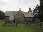 |
| Golden Grove Stable Block | Llanfihangel Aberbythych SN5962419809 51°51′33″N 4°02′23″W / 51.859171127785°N 4.0398521271702°W / 51.859171127785; -4.0398521271702 (Golden Grove Stable Block) | 27 August 1999 | Stables | To the west of the service wing at Golden Grove, to which it is linked by yards and a covered way. Rubblestone enclosing wall at north, continuing the line of the terrace wall of the house. | 22204 | Upload Photo |
| Capel Panteg and attached vestry to left | Abergwili SN4832225168 51°54′16″N 4°12′22″W / 51.904353020654°N 4.2062024285408°W / 51.904353020654; -4.2062024285408 (Capel Panteg and attached vestry to left) | 9 February 1999 | In a remote valley N of a minor road 4 km NE of Whitemill. | 22268 |  | |
| Capel Salem including forecourt railings | Llangyndeyrn SN4553913884 51°48′08″N 4°14′30″W / 51.802211142056°N 4.241577336065°W / 51.802211142056; -4.241577336065 (Capel Salem including forecourt railings) | 9 February 1999 | Chapel | In the centre of Llangyndeyrn approximately 250m SW of the B4306. | 22269 |  |
| Williams Pantycelyn Memorial Chapel | Llandovery SN7690234387 51°59′39″N 3°47′40″W / 51.994262710418°N 3.7943135803644°W / 51.994262710418; -3.7943135803644 (Williams Pantycelyn Memorial Chapel) | 2 January 2000 | Chapel | Near the centre of Llandovery on the N side of the High Street between Orchard Street and Water Street. | 22801 |  See more images |
| Cyffig Church | Eglwyscummin SN2081013933 51°47′43″N 4°36′00″W / 51.795254171915°N 4.599879762134°W / 51.795254171915; -4.599879762134 (Cyffig Church) | 10 November 2000 | Church | On the S side of a minor road 3 km SE of Whitland. | 24116 |  |
| Church of the Holy Trinity, Llanegwad | Pont-ar-Gothi, Llanegwad SN5098022611 51°52′56″N 4°09′59″W / 51.882098968773°N 4.1664901946619°W / 51.882098968773; -4.1664901946619 (Church of the Holy Trinity, Llanegwad) | 5 February 2001 | Church | About 1 km NE of Pont-ar-Gothi, in churchyard on the E side of a minor road and N bank of Afon Cothi. | 25162 |  See more images |
| Pilgrims graves by ruins of St Michael's Church | St Clears SN3027613338 51°47′34″N 4°27′45″W / 51.792870786676°N 4.4624606241329°W / 51.792870786676; -4.4624606241329 (Pilgrims graves by ruins of St Michael's Church) | 6 November 2001 | Graves | In enclosed cemetery, immediately S of the church ruins. | 25491 |  |
| Pilgrim's Graves S of ruins of St Michaels Church | St Clears SN3028713313 51°47′34″N 4°27′44″W / 51.792649566807°N 4.4622890414696°W / 51.792649566807; -4.4622890414696 (Pilgrim's Graves S of ruins of St Michaels Church) | 6 November 2001 | Graves | Near S perimeter of the cemetery. | 25492 | Upload Photo |
| W. R. H. Powell memorial in churchyard and iron railings | Llanboidy SN2166223238 51°52′45″N 4°35′32″W / 51.879102159521°N 4.5923369722422°W / 51.879102159521; -4.5923369722422 (W. R. H. Powell memorial in churchyard and iron railings) | 8 June 2001 | Memorial | In the churchyard in Llanboidy village, to the E of the parish church. | 25616 |  |
| Allt-y-Cafan Bridge | Llangeler SN3867539205 52°01′40″N 4°21′10″W / 52.027732887082°N 4.3529056663016°W / 52.027732887082; -4.3529056663016 (Allt-y-Cafan Bridge) | 6 April 1996 | Bridge | Spanning the river Teifi on the County boundary with Ceredigion on the road N of Pentrecwrt. Also in Ceredigion. | 25706 |  |
| Church of St Cynog, Llangynog | Llangynog SN3385114929 51°48′30″N 4°24′41″W / 51.808239054962°N 4.4114348759713°W / 51.808239054962; -4.4114348759713 (Church of St Cynog, Llangynog) | 17 October 2001 | Church | About 1 km S of Llangynog. | 25800 |  See more images |
| Coach House and Stable Range at Y Plas | Llansteffan SN3487910432 51°46′05″N 4°23′40″W / 51.768147344089°N 4.3943963024756°W / 51.768147344089; -4.3943963024756 (Coach House and Stable Range at Y Plas) | 11 May 2002 | Coach House/Stables | Located SW of Plas mansion, at the end of a private access road leading S from Llansteffan village. | 27075 |  |
| White Bridge (The bascule railway bridge) | Carmarthen/ Llangunnor SN4051419246 51°50′56″N 4°19′01″W / 51.848966923546°N 4.3168638662337°W / 51.848966923546; -4.3168638662337 (White Bridge (The bascule railway bridge)) | 12 May 2002 | Bascule bridge | Railway bridge over Towy river between Carmarthen and Llangunnor. | 80709 |  |
| Former Kidwelly & Llanelly Canal aqueduct | Trimsaran SN4275705300 51°43′28″N 4°16′41″W / 51.724315925315°N 4.2780039289213°W / 51.724315925315; -4.2780039289213 (Former Kidwelly & Llanelly Canal aqueduct) | 23 July 2003 | Aqueduct | Spanning the Afon Gwendraeth Fawr NW of Morfa Mawr Farm, approximately 600m NW of Llandyry church. | 81323 | Upload Photo |
| Dome gunnery trainer at Pembrey Airfield | Pembrey and Burryport SN4075703714 51°42′34″N 4°18′22″W / 51.709501735234°N 4.3062098837196°W / 51.709501735234; -4.3062098837196 (Dome gunnery trainer at Pembrey Airfield) | 25 November 2003 | Dome trainer building | In a field on the E side of the former airfield, approximately 550m NW of Brooklands Farmhouse. | 82066 |  |
Notes
- ^ Sometimes known as OSGB36, the grid reference is based on the British national grid reference system used by the Ordnance Survey.
See also
 Wales portal

- Grade I listed buildings in Carmarthenshire
- Registered historic parks and gardens in Carmarthenshire
References
External links
![]() Media related to Grade II* listed buildings in Carmarthenshire at Wikimedia Commons
Media related to Grade II* listed buildings in Carmarthenshire at Wikimedia Commons
- v
- t
- e
 Architecture
 Wales
Wales


| |||
|---|---|---|---|
| Principal settlements | | ||
| Towns and villages |
| ||
| Buildings and structures |
| ||
| Rivers | |||
| Topics |
| ||
| |||


