Grade II* listed buildings in Ceredigion

Map all coordinates using OpenStreetMap
Download coordinates as:
- KML
- GPX (all coordinates)
- GPX (primary coordinates)
- GPX (secondary coordinates)
In the United Kingdom, the term listed building refers to a building or other structure officially designated as being of special architectural, historical, or cultural significance; Grade II* structures are those considered to be "particularly important buildings of more than special interest".[1] Listing was begun by a provision in the Town and Country Planning Act 1947. Once listed, strict limitations are imposed on the modifications allowed to a building's structure or fittings. In Wales, the authority for listing under the Planning (Listed Buildings and Conservation Areas) Act 1990[2] rests with Cadw.
Buildings
| Name | Location Grid Ref.[note 1] Geo-coordinates | Date Listed | Function | Notes | Reference Number | Image |
|---|---|---|---|---|---|---|
| Church of All Saints, Llanfair Clydogau | Cellan, Llanfair Clydogau SN6135549746 52°07′43″N 4°01′37″W / 52.128591379458°N 4.0268484974539°W / 52.128591379458; -4.0268484974539 (Church of All Saints, Llanfair Clydogau) | 3 June 1964 | Church | Situated some 1.2 km NE of Cellan village, on N side of B4343 to Llanfair. | 9759 |  See more images |
| Church of Saint David, Llanarth | Llanarth SN4229457749 52°11′43″N 4°18′32″W / 52.195361149301°N 4.3087955898992°W / 52.195361149301; -4.3087955898992 (Church of Saint David, Llanarth) | 6 March 1964 | Church | Situated in Llanarth village on hill W of main road. | 9768 |  See more images |
| Mynachdy | Dyffryn Arth SN5043561992 52°14′09″N 4°11′30″W / 52.235753503168°N 4.1916591359145°W / 52.235753503168; -4.1916591359145 (Mynachdy) | 6 March 1964 | House | Situated some 1.5 km SSW of Pennant on W side of road to Ciliau Aeron. | 9801 |  |
| Church of St. Ffraed, Llansantffraid | Llansantffraid SN5124667491 52°17′07″N 4°10′56″W / 52.285375403564°N 4.1822171488936°W / 52.285375403564; -4.1822171488936 (Church of St. Ffraed, Llansantffraid) | 6 March 1964 | Church | Situated at the end of Stryd-y-Eglwys from Llanon, some 350m E of the coast at Llansantffraed and 50m N of the Afon Peris. | 9815 |  See more images |
| Plas Gwyn, Llansantffraid, Ceredigion | Llansantffraid SN5274568352 52°17′37″N 4°09′38″W / 52.29351514397°N 4.1606347652322°W / 52.29351514397; -4.1606347652322 (Plas Gwyn, Llansantffraid, Ceredigion) | 6 March 1964 | House | Situated some 1.5km NE of Llanon approached by a 250m drive S of the A487. | 9816 |  Upload Photo |
| Plas y Wern | Llanarth SN4155158539 52°12′08″N 4°19′12″W / 52.202244136373°N 4.3200263950374°W / 52.202244136373; -4.3200263950374 (Plas y Wern) | 28 February 1952 | House | Situated on E side of B4342, about 1 km NNW of Llanarth. | 9819 | Upload Photo |
| Derry Ormond Tower | Llangybi SN5898351680 52°08′43″N 4°03′44″W / 52.145366173906°N 4.062279052669°W / 52.145366173906; -4.062279052669 (Derry Ormond Tower) | 28 February 1952 | Tower | Situated very prominently overlooking the Dulas valley from a 219 m spur of hill between the two minor valleys of the Afon Denys and Nant Dyfel. Reached across fields from Penparc Farm. | 9820 |  |
| Dyfi Furnace | Ysgubor y Coed SN6849595146 52°32′18″N 3°56′25″W / 52.538261560853°N 3.9403861586175°W / 52.538261560853; -3.9403861586175 (Dyfi Furnace) | 31 May 1972 | Furnace | Situated in Furnace by the bridge. | 9822 | 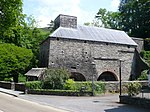 |
| Church of Saint Ilar, Llanilar | Llanilar SN6237975101 52°21′24″N 4°01′20″W / 52.356655591496°N 4.022233721155°W / 52.356655591496; -4.022233721155 (Church of Saint Ilar, Llanilar) | 21 January 1964 | Church | Situated in large churchyard in the centre of the village. | 9840 |  See more images |
| Mabws Hall | Llanrhystyd SN5653468549 52°17′47″N 4°06′19″W / 52.29628987073°N 4.1052016239331°W / 52.29628987073; -4.1052016239331 (Mabws Hall) | 21 October 1964 | House | In Cwm Mabws. Reached at end of driveway off E side of road, 1km NE of Rhyd-Rosser.[3][4] | 9842 |  |
| St Michael's Church, Llanfihangel y Creuddyn | Trawsgoed SN6650876051 52°21′58″N 3°57′43″W / 52.366214527794°N 3.9620215507011°W / 52.366214527794; -3.9620215507011 (St Michael's Church, Llanfihangel y Creuddyn) | 21 January 1964 | Church | Situated in centre of the village in large churchyard. | 9850 |  See more images |
| Eglwys Newydd Church | Pontarfynach SN7685573639 52°20′49″N 3°48′33″W / 52.346969320766°N 3.8092555670892°W / 52.346969320766; -3.8092555670892 (Eglwys Newydd Church) | 21 January 1964 | Church | On the S side of the B4574 and the N side of the Ystwyth valley some 1km NE of the site of Hafod Mansion. | 9867 |  See more images |
| Devil's Bridge, Ceredigion | Pontarfynach SN7417377026 52°22′36″N 3°51′00″W / 52.376792878038°N 3.8498777325241°W / 52.376792878038; -3.8498777325241 (Devil's Bridge, Ceredigion) | 21 January 1964 | Bridge | Carrying the A4120 across the gorge of the Afon Mynach on the E side of Devil's Bridge. | 9870 |  |
| Newcastle Emlyn Bridge | Llandyfriog SN3091340867 52°02′25″N 4°28′00″W / 52.040343404503°N 4.4667565696593°W / 52.040343404503; -4.4667565696593 (Newcastle Emlyn Bridge) | 21 September 1964 | Bridge | Situated between Adpar and Newcastle Emlyn, spanning River Teifi (parish and old county boundary) | 9880 |  |
| Cenarth Bridge | Beulah SN2691641581 52°02′44″N 4°31′31″W / 52.045519585413°N 4.5253351810248°W / 52.045519585413; -4.5253351810248 (Cenarth Bridge) | 21 September 1964 | Bridge | Situated on A484, spanning Teifi at Cenarth Falls | 9881 |  |
| Penylan | Beulah SN2358043813 52°03′52″N 4°34′30″W / 52.064511550204°N 4.5750814145018°W / 52.064511550204; -4.5750814145018 (Penylan) | 21 September 1964 | Situated down drive from formal entry some 400m NE of Llechryd Water Works, on E side of lane to Neuadd Cross from A 484. | 9884 |  | |
| Church of St Cynllo, Llangoedmor | Llangoedmor SN1994445802 52°04′52″N 4°37′45″W / 52.08120151989°N 4.6291144584746°W / 52.08120151989; -4.6291144584746 (Church of St Cynllo, Llangoedmor) | 21 September 1964 | Church | Situated on lane between A484 and B4570 some 500m N of Croesllan crossroads. | 9890 |  |
| Plas Llangoedmore | Llangoedmor SN1969245957 52°04′57″N 4°37′58″W / 52.082511314161°N 4.6328698624883°W / 52.082511314161; -4.6328698624883 (Plas Llangoedmore) | 21 September 1964 | House | Situated some 700m E of junction of B4570 with A484 to E of Cardigan | 9891 | Upload Photo |
| Treforgan | Treforgan, Llangoedmor SN2011446062 52°05′01″N 4°37′36″W / 52.083592030825°N 4.6267735271437°W / 52.083592030825; -4.6267735271437 (Treforgan) | 21 September 1964 | House | Situated above road, approached by drive opposite lane from Llangoedmor Church.[5][6] | 9892 | Upload Photo |
| Pantgwyn | Llangoedmor SN2394145955 52°05′02″N 4°34′15″W / 52.08386509427°N 4.5709264484153°W / 52.08386509427; -4.5709264484153 (Pantgwyn) | 21 September 1964 | Situated down short drive beginning some 40m N of B4570 crossroads at Penllwyndu. | 9893 | Upload Photo | |
| Llechryd Bridge | Llangoedmor SN2179743627 52°03′44″N 4°36′03″W / 52.062268626237°N 4.6009663352119°W / 52.062268626237; -4.6009663352119 (Llechryd Bridge) | 21 September 1964 | Bridge | Situated across Afon Teifi between Llechryd and Castell Malgwyn lodge. | 9895 |  |
| Great Abbey Farmhouse including front garden wall | Ystrad Fflur SN7466265688 52°16′30″N 3°50′18″W / 52.275027244931°N 3.8384683644107°W / 52.275027244931; -3.8384683644107 (Great Abbey Farmhouse including front garden wall) | 12 May 1963 | Farmhouse | Situated next to Strata Florida Abbey. | 9914 | Upload Photo |
| Edward Richard Old Grammar School | Ystrad Meurig SN7036867670 52°17′31″N 3°54′08″W / 52.291838285898°N 3.9021300960167°W / 52.291838285898; -3.9021300960167 (Edward Richard Old Grammar School) | 12 May 1963 | School | Situated set back from road to W of St John's Church. | 9916 |  |
| Capel Gwynfil | Llangeitho SN6204259792 52°13′08″N 4°01′15″W / 52.219025188124°N 4.0209072329964°W / 52.219025188124; -4.0209072329964 (Capel Gwynfil) | 12 May 1963 | Chapel | Situated some 200m NE of centre of Llangeitho, on E side of road. | 9917 | 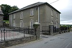 See more images |
| Church of Saint David, Llanddewi Brefi | Llanddewi Brefi SN6638355311 52°10′47″N 3°57′20″W / 52.179835263046°N 3.9556339120281°W / 52.179835263046; -3.9556339120281 (Church of Saint David, Llanddewi Brefi) | 12 May 1963 | Church | Situated in centre of Llanddewi Brefi. | 9920 |  See more images |
| Pont Gogoyan | Llanddewi Brefi SN6418054471 52°10′18″N 3°59′15″W / 52.171748707782°N 3.9874964101805°W / 52.171748707782; -3.9874964101805 (Pont Gogoyan) | 12 May 1963 | Bridge | Situated some 2.25 km WSW of Llanddewi Brefi, on minor road between B4343 and A485. | 9921 |  |
| No. 10 Alban Square | Aberaeron SN4597062927 52°14′35″N 4°15′27″W / 52.242918822708°N 4.257416922734°W / 52.242918822708; -4.257416922734 (No. 10 Alban Square) | 28 September 1961 | 9939 |  | ||
| No. 11 Alban Square | Aberaeron SN4597462922 52°14′34″N 4°15′26″W / 52.242875028312°N 4.2573561056321°W / 52.242875028312; -4.2573561056321 (No. 11 Alban Square) | 28 September 1961 | House (Pale yellow) | 9940 | 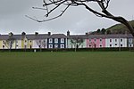 | |
| No. 12 Alban Square | Aberaeron SN4597762916 52°14′34″N 4°15′26″W / 52.242821970039°N 4.2573094666338°W / 52.242821970039; -4.2573094666338 (No. 12 Alban Square) | 28 September 1961 | House (white) | 9941 | | |
| No. 13 Alban Square | Aberaeron SN4598362910 52°14′34″N 4°15′26″W / 52.242769753314°N 4.2572189255231°W / 52.242769753314; -4.2572189255231 (No. 13 Alban Square) | 28 September 1961 | House (Yellow) | Part of NE side of planned square between the Midland Bank (north Road) forming the NW end pavilion, and no 15 the central pavilion. | 9942 | |
| No. 14 Alban Square | Aberaeron SN4598762904 52°14′34″N 4°15′26″W / 52.242716975495°N 4.2571576527426°W / 52.242716975495; -4.2571576527426 (No. 14 Alban Square) | 28 September 1961 | House (White) | 9943 |  | |
| No. 15 Alban Square | Aberaeron SN4599262898 52°14′34″N 4°15′25″W / 52.242664478146°N 4.2570817460665°W / 52.242664478146; -4.2570817460665 (No. 15 Alban Square) | 28 September 1961 | House (Dark Blue/Green) | 9944 |  | |
| No. 16 Alban Square | Aberaeron SN4599962889 52°14′33″N 4°15′25″W / 52.242585591781°N 4.2569752033979°W / 52.242585591781; -4.2569752033979 (No. 16 Alban Square) | 28 September 1961 | House (pale green) | 9945 |  | |
| No. 17 Alban Square | Aberaeron SN4600662882 52°14′33″N 4°15′25″W / 52.242524671945°N 4.2568695731431°W / 52.242524671945; -4.2568695731431 (No. 17 Alban Square) | 28 September 1961 | House (pink) | 9946 | | |
| No. 18 Alban Square | Aberaeron SN4601162876 52°14′33″N 4°15′24″W / 52.2424721744°N 4.2567936671368°W / 52.2424721744; -4.2567936671368 (No. 18 Alban Square) | 28 September 1961 | House (grey-green) | 9947 | | |
| No. 19 Alban Square | Aberaeron SN4601662868 52°14′33″N 4°15′24″W / 52.24240171017°N 4.2567168493404°W / 52.24240171017; -4.2567168493404 (No. 19 Alban Square) | 28 September 1961 | House (blue) | 9948 | | |
| No. 20 Alban Square (Barclay's Bank) | Aberaeron SN4602162860 52°14′32″N 4°15′24″W / 52.242331245885°N 4.2566400317894°W / 52.242331245885; -4.2566400317894 (No. 20 Alban Square (Barclay's Bank)) | 28 September 1961 | Bank | 9949 | 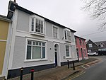 | |
| No. 9 Alban Square (HSBC Bank) | Aberaeron SN4596562932 52°14′35″N 4°15′27″W / 52.242962336518°N 4.2574923740922°W / 52.242962336518; -4.2574923740922 (No. 9 Alban Square (HSBC Bank)) | 28 September 1961 | Bank | 10077 |  | |
| No. 1 Portland Place | Aberaeron SN4579162808 52°14′30″N 4°15′36″W / 52.241799563699°N 4.2599820856508°W / 52.241799563699; -4.2599820856508 (No. 1 Portland Place) | 28 September 1961 | House (cream) | 10080 |  | |
| No. 2 Portland Place (formerly the customs house) | Aberaeron SN4578362803 52°14′30″N 4°15′36″W / 52.241752400274°N 4.2600968721849°W / 52.241752400274; -4.2600968721849 (No. 2 Portland Place (formerly the customs house)) | 28 September 1961 | House (pink) | 10081 |  | |
| No. 3 Portland Place | Aberaeron SN4577662797 52°14′30″N 4°15′37″W / 52.24169653433°N 4.2601965681026°W / 52.24169653433; -4.2601965681026 (No. 3 Portland Place) | 28 September 1961 | House (magenta) | 10082 | | |
| No. 4 Portland Place | Aberaeron SN4576962792 52°14′30″N 4°15′37″W / 52.241649651599°N 4.2602967204644°W / 52.241649651599; -4.2602967204644 (No. 4 Portland Place) | 28 September 1961 | House (dark blue) | 10083 | | |
| No. 5 Portland Place | Aberaeron SN4576162787 52°14′30″N 4°15′37″W / 52.241602487873°N 4.2604115062732°W / 52.241602487873; -4.2604115062732 (No. 5 Portland Place) | 28 September 1961 | House (pale purple) | 10084 |  | |
| No. 6 Portland Place | Aberaeron SN4575362783 52°14′30″N 4°15′38″W / 52.241564307332°N 4.2605267485768°W / 52.241564307332; -4.2605267485768 (No. 6 Portland Place) | 28 September 1961 | House (pale green) | 10085 | | |
| No. 7 Portland Place | Aberaeron SN4574662778 52°14′29″N 4°15′38″W / 52.241517424326°N 4.2606269002884°W / 52.241517424326; -4.2606269002884 (No. 7 Portland Place) | 28 September 1961 | House | 10086 | 
| |
| Assembly Rooms, Laura Place | Aberystwyth SN5810981590 52°24′50″N 4°05′16″W / 52.413862439742°N 4.0876389186921°W / 52.413862439742; -4.0876389186921 (Assembly Rooms, Laura Place) | 21 July 1961 | Assembly rooms | At the west end of the street with rear elevation overlooking Laura Place and the Parish Church. | 10242 |  |
| No. 1 Laura Place | Aberystwyth SN5809181690 52°24′53″N 4°05′17″W / 52.414756166138°N 4.0879458318117°W / 52.414756166138; -4.0879458318117 (No. 1 Laura Place) | 21 July 1961 | Planned terrace overlooking Laura Gardens and the Parish Church to W; stepped in the slope between King Street and New Street. Named after Laura Powell, nee. Phelps, who married W E Powell of Nanteos. | 10257 |  | |
| No. 2 Laura Place | Aberystwyth SN5809581680 52°24′53″N 4°05′16″W / 52.414667365569°N 4.0878828162991°W / 52.414667365569; -4.0878828162991 (No. 2 Laura Place) | 21 July 1961 | House | Planned terrace overlooking Laura Gardens and the Parish church to W; stepped in the slope between King Street and New Street. Named after Laura Powell, nee. Phelps, who married W E Powell of Nanteos. | 10258 |  |
| No. 3 Laura Place | Aberystwyth SN5809881672 52°24′53″N 4°05′16″W / 52.414596273085°N 4.0878353425805°W / 52.414596273085; -4.0878353425805 (No. 3 Laura Place) | 21 July 1961 | House | Planned terrace overlooking Laura Gardens and the Parish church to W; stepped in the slope between King Street and New Street. Named after Laura Powell, nee. Phelps, who married W E Powell of Nanteos. | 10259 |  |
| No. 4 Laura Place | Aberystwyth SN5810281664 52°24′52″N 4°05′16″W / 52.414525440575°N 4.0877731765088°W / 52.414525440575; -4.0877731765088 (No. 4 Laura Place) | 21 July 1961 | House | Planned terrace overlooking Laura Gardens and the Parish church to W; stepped in the slope between King Street and New Street. Named after Laura Powell, nee. Phelps, who married W E Powell of Nanteos. | 10260 | 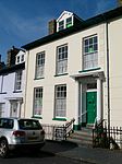 |
| No. 5 Laura Place | Aberystwyth SN5810681655 52°24′52″N 4°05′16″W / 52.414445623966°N 4.0877105861605°W / 52.414445623966; -4.0877105861605 (No. 5 Laura Place) | 21 July 1961 | House | Planned terrace overlooking Laura Gardens and the Parish church to W; stepped in the slope between King Street and New Street. Named after Laura Powell, nee. Phelps, who married W E Powell of Nanteos. | 10261 |  |
| No. 6 Laura Place | Aberystwyth SN5810981647 52°24′52″N 4°05′16″W / 52.414374531405°N 4.0876631129653°W / 52.414374531405; -4.0876631129653 (No. 6 Laura Place) | 21 July 1961 | House | Planned terrace overlooking Laura Gardens and the Parish church to W; stepped in the slope between King Street and New Street. Named after Laura Powell, nee. Phelps, who married W E Powell of Nanteos. | 10262 |  |
| No. 7 Laura Place (the rectory) | Aberystwyth SN5811881632 52°24′51″N 4°05′15″W / 52.414242110178°N 4.0875245142375°W / 52.414242110178; -4.0875245142375 (No. 7 Laura Place (the rectory)) | 21 July 1961 | House | 10263 |  | |
| No. 8 Laura Place | Aberystwyth SN5811981623 52°24′51″N 4°05′15″W / 52.414161513554°N 4.0875060019222°W / 52.414161513554; -4.0875060019222 (No. 8 Laura Place) | 21 July 1961 | House | 10264 |  | |
| No. 9 Laura Place (staff house) | Aberystwyth SN5812581611 52°24′51″N 4°05′15″W / 52.414055264489°N 4.0874127546215°W / 52.414055264489; -4.0874127546215 (No. 9 Laura Place (staff house)) | 21 July 1961 | House | 10265 |  | |
| No. 11 Laura Place | Aberystwyth SN5808981577 52°24′49″N 4°05′17″W / 52.413740447057°N 4.0879272457758°W / 52.413740447057; -4.0879272457758 (No. 11 Laura Place) | 21 July 1961 | House | To W of the former Assembly Rooms, above and to the S of the Parish church; on sloping ground. At one time the town house and estate office of the Powells of Nanteos. | 10266 |  |
| No. 12 Laura Place | Aberystwyth SN5808081574 52°24′49″N 4°05′17″W / 52.413711154701°N 4.0880582023716°W / 52.413711154701; -4.0880582023716 (No. 12 Laura Place) | 21 July 1961 | To W of the former Assembly Rooms, above and to the S of the Parish church; on sloping ground. At one time the town house and estate office of the Powells of Nanteos. | 10267 | | |
| No. 46 Marine Terrace | Aberystwyth SN5836582084 52°25′06″N 4°05′03″W / 52.418367069834°N 4.0840870159467°W / 52.418367069834; -4.0840870159467 (No. 46 Marine Terrace) | 24 November 1987 | House | Royal Commission on the Ancient and Historical Monuments of Wales | 10291 |  |
| National Library of Wales | Aberystwyth SN5941581622 52°24′52″N 4°04′06″W / 52.414487896657°N 4.0684640561748°W / 52.414487896657; -4.0684640561748 (National Library of Wales) | 21 July 1961 | Library | Prominent elevated site facing W above the town centre, reached by a road off Penglais Hill. | 10417 |  See more images |
| St David's Building, University of Wales Trinity Saint David | Lampeter SN5791648221 52°06′50″N 4°04′35″W / 52.114014509725°N 4.0764154658872°W / 52.114014509725; -4.0764154658872 (St David's Building, University of Wales Trinity Saint David) | 21 September 1964 | University | 10431 |  See more images | |
| Cardigan Bridge | Cardigan SN1777845818 52°04′50″N 4°39′39″W / 52.080634357804°N 4.6606964467955°W / 52.080634357804; -4.6606964467955 (Cardigan Bridge) | 14 April 1992 | Bridge | 10456 |  | |
| Castle Green House | Cardigan SN1779845947 52°04′54″N 4°39′38″W / 52.081799487742°N 4.6604738512174°W / 52.081799487742; -4.6604738512174 (Castle Green House) | 16 June 1961 | House | 10459 |  See more images | |
| Parish church of St Mary, Cardigan | Cardigan SN1810246043 52°04′58″N 4°39′22″W / 52.082761927055°N 4.6560936591926°W / 52.082761927055; -4.6560936591926 (Parish church of St Mary, Cardigan) | 16 June 1961 | Church | 10476 |  See more images | |
| Cardigan Guildhall and markets | Cardigan SN1777146164 52°05′01″N 4°39′40″W / 52.083739412491°N 4.6609834192966°W / 52.083739412491; -4.6609834192966 (Cardigan Guildhall and markets) | 16 June 1961 | Guildhall | 10479 |  | |
| The old Shire Hall | Cardigan SN1773145978 52°04′55″N 4°39′41″W / 52.082055770225°N 4.6614670802664°W / 52.082055770225; -4.6614670802664 (The old Shire Hall) | 16 June 1961 | Shire Hall | South end of High Street[7][8] | 10488 |  |
| No. 7 St Mary's Street | Cardigan SN1781546021 52°04′57″N 4°39′37″W / 52.082469681231°N 4.6602655859432°W / 52.082469681231; -4.6602655859432 (No. 7 St Mary's Street) | 16 June 1961 | House | 10529 | Upload Photo | |
| No. 40 St Mary's Street (Avondale) | Cardigan SN1786446005 52°04′56″N 4°39′34″W / 52.082342161089°N 4.6595427556286°W / 52.082342161089; -4.6595427556286 (No. 40 St Mary's Street (Avondale)) | 14 April 1992 | House | 10539 | Upload Photo | |
| Bethania Baptist Chapel | Cardigan SN1790446187 52°05′02″N 4°39′33″W / 52.083989873006°N 4.6590568825366°W / 52.083989873006; -4.6590568825366 (Bethania Baptist Chapel) | 14 April 1992 | Chapel | 10545 |  See more images | |
| Railings, gates and gatepiers at Bethania Baptist Chapel | Cardigan SN1790546201 52°05′03″N 4°39′33″W / 52.084115934686°N 4.659049783132°W / 52.084115934686; -4.659049783132 (Railings, gates and gatepiers at Bethania Baptist Chapel) | 14 April 1992 | 10546 |  See more images | ||
| Bryn-y-Mor | Cardigan SN1689647352 52°05′39″N 4°40′28″W / 52.094118882021°N 4.6743769816231°W / 52.094118882021; -4.6743769816231 (Bryn-y-Mor) | 22 August 1986 | House | 10547 |  | |
| Albro Castle | Cardigan SN1604046729 52°05′18″N 4°41′11″W / 52.088239164121°N 4.6865217332204°W / 52.088239164121; -4.6865217332204 (Albro Castle) | 14 April 1992 | Workhouse | Situated down track running west off Poppit Road, just on St Dogmael's north boundary. | 10556 |  |
| Church of St Tysul | Llandysul SN4190340692 52°02′31″N 4°18′24″W / 52.042022981557°N 4.3065834386742°W / 52.042022981557; -4.3065834386742 (Church of St Tysul) | 21 September 1964 | Church | Situated by River Teifi in large churchyard. | 10574 |  |
| Alltyrodyn Hall | Llandysul SN4499144240 52°04′29″N 4°15′48″W / 52.074770907245°N 4.2632077700164°W / 52.074770907245; -4.2632077700164 (Alltyrodyn Hall) | 13 January 1993 | Includes rear courtyard and bell tower[9] | 10643 | Upload Photo | |
| Capel Llwynrhydowen | Llandysul SN4436545211 52°05′00″N 4°16′22″W / 52.083317822622°N 4.2727774445371°W / 52.083317822622; -4.2727774445371 (Capel Llwynrhydowen) | 21 September 1964 | Chapel | 10655 | Upload Photo | |
| Gelli, Nantcwnlle | Nantcwnlle SN5460657302 52°11′41″N 4°07′43″W / 52.194737957924°N 4.1286090537722°W / 52.194737957924; -4.1286090537722 (Gelli, Nantcwnlle) | 14 January 1977 | Situated some 400m NW of Trefilan, approached by two drives off minor lane to Cilcennin. | 10689 | Upload Photo | |
| Plas Abermad | Llanilar SN6002476089 52°21′54″N 4°03′26″W / 52.364934467106°N 4.0572025968812°W / 52.364934467106; -4.0572025968812 (Plas Abermad) | 20 December 1989 | House | Set in its own grounds on the floor of the Ystwyth Valley. Reached by short drive curving N off the A485 midway between Llanfarian and Llanilar.[10][11] | 10710 |  |
| Church of St Peter, Ceulanamaesmawr | Ceulanamaesmawr SN6841286457 52°27′37″N 3°56′17″W / 52.460172956618°N 3.9381714021979°W / 52.460172956618; -3.9381714021979 (Church of St Peter, Ceulanamaesmawr) | 18 July 1990 | Church | Situated in village on S side of lane running ENE from main valley road, about 150m E of junction.[12][13] | 10712 |  |
| Billiard Room at Llanerchaeron | Ciliau Aeron SN4795460219 52°13′09″N 4°13′38″W / 52.219144482985°N 4.2271638619405°W / 52.219144482985; -4.2271638619405 (Billiard Room at Llanerchaeron) | 6 March 1964 | Billiard room | Detached building situated on E side of rear approach to main house, some 10m NE of entry to rear court. | 10716 | Upload Photo |
| Edward Davies memorial chemical laboratories | Aberystwyth SN5880781537 52°24′49″N 4°04′39″W / 52.413567296952°N 4.0773612605924°W / 52.413567296952; -4.0773612605924 (Edward Davies memorial chemical laboratories) | 19 December 1986 | Art school | Elevated above the town on Buarth Mawr; set into the hillside. | 10729 |  See more images |
| Hafod Arms Hotel | Pontarfynach SN7410577044 52°22′37″N 3°51′03″W / 52.376938958403°N 3.8508828785425°W / 52.376938958403; -3.8508828785425 (Hafod Arms Hotel) | 30 July 1991 | Hotel | Facing N on the bend in the road immediately W of the famous Devil's Bridge and Mynach Falls and at the junction with the B4574. | 10734 |  |
| Church of St Cynllo | Llangynllo (in Troedyraur) SN3518743946 52°04′09″N 4°24′22″W / 52.06929154686°N 4.4059867860245°W / 52.06929154686; -4.4059867860245 (Church of St Cynllo) | 2 October 1994 | Church | Situated by Glebe Farm, some 1km SSW of Coedybryn [14][15] and some 4 km SW of Ffostrasol, off B4334 running SE. | 10831 |  |
| Pontbrenmydyr | Henfynyw SN4761160100 52°13′05″N 4°13′56″W / 52.217980435633°N 4.2321271493084°W / 52.217980435633; -4.2321271493084 (Pontbrenmydyr) | 3 August 1994 | Set into the slope above Afon Mydyr, in sight of Llanerchaeron House. Reached off the E side of the A482 down a short lane past Minafon. | 14427 | Upload Photo | |
| St Michael's Church, Tremain | Y Ferwig SN2353848633 52°06′28″N 4°34′41″W / 52.107788605012°N 4.5781888716532°W / 52.107788605012; -4.5781888716532 (St Michael's Church, Tremain) | 3 June 1995 | Church | Situated near a minor road 200m S of A487 at Tremain.[16][17] | 15871 | 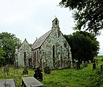 See more images |
| Tre-berfedd including kitchen wing forward on right | Llanfihangel Ystrad SN5031654622 52°10′10″N 4°11′25″W / 52.16951066035°N 4.1901411116876°W / 52.16951066035; -4.1901411116876 (Tre-berfedd including kitchen wing forward on right) | 20 March 1996 | Farmhouse | Farm at end of short track off E side of Cribyn-Dihewyd by-road. Situated approximately 0.75km SE of Dihewyd. | 16591 | Upload Photo |
| Trawsgoed House | Trawsgoed SN6707073076 52°20′23″N 3°57′09″W / 52.339621353003°N 3.9525938206642°W / 52.339621353003; -3.9525938206642 (Trawsgoed House) | 9 June 1996 | Country House | Situated in own grounds on E side of Afon Ystwyth, approached by drive from lodge some 150m N of Pont Trawsgoed. | 17258 | 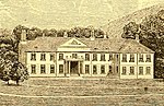 See more images |
| Felin-hafodwen | Llanfihangel Ystrad SN5159750916 52°08′12″N 4°10′11″W / 52.136562839429°N 4.1698043911203°W / 52.136562839429; -4.1698043911203 (Felin-hafodwen) | 18 October 1996 | Mill | Situated on E side of by-road, some 0.5km SW of Cribyn. | 17436 | Upload Photo |
| Ynys-felen | Llanfihangel Ystrad SN4957954523 52°10′06″N 4°12′03″W / 52.168420389014°N 4.2008652190058°W / 52.168420389014; -4.2008652190058 (Ynys-felen) | 18 October 1996 | House | At end of track off E side of Dihewyd-Troedyrhiw by-road, 1.8km SE of Dihewyd. | 17442 | Upload Photo |
| Ty Glyn including attached wings to main gable ends | Dyffryn Arth SN4986459896 52°13′00″N 4°11′57″W / 52.216767891767°N 4.1990832051739°W / 52.216767891767; -4.1990832051739 (Ty Glyn including attached wings to main gable ends) | 6 March 1964 | House | Situated about 1 km N of Ciliau Aeron by junction of roads to Aberarth and to Pennant. | 17509 | Upload Photo |
| Capel Eidalwyr | Llandyfriog SN3566740177 52°02′08″N 4°23′50″W / 52.035578755374°N 4.3971766321054°W / 52.035578755374; -4.3971766321054 (Capel Eidalwyr) | 6 April 1996 | Detached utilitarian building towards SE corner of caravan park, which is located on the E side of the B4334, 0.3 km SW of Henllan. | 17608 | Upload Photo | |
| Pont Allt-y-Cafan | Llandyfriog SN3867539209 52°01′40″N 4°21′10″W / 52.027768819225°N 4.3529075533091°W / 52.027768819225; -4.3529075533091 (Pont Allt-y-Cafan) | 6 April 1996 | Bridge | Deep valley setting, carrying Horeb to Pentre-cwrt by-road over River Teifi (parish and old county boundary). 0.3km S of Pentre-cwrt. Also in Carmarthenshire. | 17613 |  |
| Dolwerdd | Nantcwnlle SN5656756955 52°11′32″N 4°05′59″W / 52.192135227208°N 4.0997926994019°W / 52.192135227208; -4.0997926994019 (Dolwerdd) | 26 November 1996 | Situated behind farm-buildings of Gwastod, some 0.5 km NE of Abermeurig house. | 17797 | Upload Photo | |
| Llanon Cottage | Llansantffraid SN5147366845 52°16′47″N 4°10′43″W / 52.27963345674°N 4.1786070472251°W / 52.27963345674; -4.1786070472251 (Llanon Cottage) | 30 April 1996 | House | Situated some 50m off the E side of Bridge Street, Llanon, on the E side of Heol Non. | 17894 |  |
| Felin Geri | Beulah SN3004042306 52°03′11″N 4°28′49″W / 52.053001058761°N 4.4801882395888°W / 52.053001058761; -4.4801882395888 (Felin Geri) | 15 March 1996 | Mill | Situated about 1 km E of Cwm Cou, in Ceri valley, on S side of lane. | 17953 | Upload Photo |
| Noyadd Trefawr | Beulah SN2583946224 52°05′13″N 4°32′36″W / 52.086883320872°N 4.5433930754309°W / 52.086883320872; -4.5433930754309 (Noyadd Trefawr) | 21 September 1964 | Situated some 400m N of Neuadd Cross, on E side of lane to Blaenannerch. | 17967 | Upload Photo | |
| Church of St Michael, Eglwys Fach | Ysgubor y Coed SN6856295528 52°32′30″N 3°56′22″W / 52.541709922494°N 3.9395502326449°W / 52.541709922494; -3.9395502326449 (Church of St Michael, Eglwys Fach) | 17 February 1997 | Church | Situated at S end of village in large churchyard, with lych-gate to road. | 18242 |  See more images |
| Crugiau | Llanfarian SN5913879406 52°23′40″N 4°04′18″W / 52.39450755923°N 4.0716006558621°W / 52.39450755923; -4.0716006558621 (Crugiau) | 17 September 1987 | Situated down drive leading W from the A487 at Rhydyfelin from Crugiau Lodge. | 18288 | Upload Photo | |
| Rhiwson Uchaf house-and-byre | Llanwenog SN5047346815 52°05′58″N 4°11′04″W / 52.099415911065°N 4.1844120029562°W / 52.099415911065; -4.1844120029562 (Rhiwson Uchaf house-and-byre) | 25 April 1997 | Situated some 600m NNE of Drefach, reached by minor lane running NNE of B4338, and down drive from right angle bend at Rhiwson Isaf. | 18374 | Upload Photo | |
| Ceulan Mills | Ceulanamaesmawr SN6558489413 52°29′10″N 3°58′51″W / 52.486041156036°N 3.9809605336154°W / 52.486041156036; -3.9809605336154 (Ceulan Mills) | 19 September 1997 | Mill | Situated behind houses on main road, on W bank of Ceulan, approached through grounds of Glenydd and Wern. | 18885 | Upload Photo |
| Bethel Independent Chapel, Ceulanamaesmawr | Tal-y-bont, Ceulanamaesmawr SN6549689557 52°29′14″N 3°58′56″W / 52.487313196564°N 3.9823138463365°W / 52.487313196564; -3.9823138463365 (Bethel Independent Chapel, Ceulanamaesmawr) | 19 September 1997 | Chapel | Situated towards N end of Talybont, adjoining and to N of Tabernacle Chapel, both behind matching iron railings. | 18891 |  See more images |
| Capel Soar and attached house | Llanddewi Brefi SN7846953283 52°09′52″N 3°46′42″W / 52.164412497444°N 3.778240260144°W / 52.164412497444; -3.778240260144 (Capel Soar and attached house) | 30 September 1997 | Chapel | Situated in extreme isolation on W bank of the Camddwr some 13 km from Tregaron, reached via the Abergwesyn road to Nant-y-maen and then the road S towards Llyn Brianne reservoir.[18][19] | 18943 |  See more images |
| All Saints' Church, Llangorwen | Llangorwen, Tirymynach SN6033883832 52°26′04″N 4°03′21″W / 52.434580017326°N 4.0558265320719°W / 52.434580017326; -4.0558265320719 (All Saints' Church, Llangorwen) | 11 December 1997 | Church | Situated in Clarach valley, on E side of B 4572 just S of Clarach crossroads and just N of Pont Llangorwen. | 19068 |  See more images |
| St David's Church, Capel Bangor | Capel Bangor, Melindwr SN6561280129 52°24′09″N 3°58′37″W / 52.402634788928°N 3.9768092696881°W / 52.402634788928; -3.9768092696881 (St David's Church, Capel Bangor) | 1 February 1998 | Church | Situated just S of A44 about 50m down road to Cwm Rheidol on W side of road. | 19170 |  |
| Stable court at Nanteos, including attached outbuilding to S | Llanfarian SN6206278639 52°23′18″N 4°01′42″W / 52.388362783345°N 4.0283417309579°W / 52.388362783345; -4.0283417309579 (Stable court at Nanteos, including attached outbuilding to S) | 24 February 2004 | Stables | Situated on rising ground to the north east of Nanteos Mansion, with entrance on E side. | 82510 |  |
| Barn above Dyfi Furnace | Ysgubor y Coed SN6849495099 52°32′16″N 3°56′25″W / 52.53783903842°N 3.9403822674657°W / 52.53783903842; -3.9403822674657 (Barn above Dyfi Furnace) | 23 November 2004 | Barn | Situated on slope behind the Dyfi Furnace, reached by footpath. | 83255 | Upload Photo |
| Ynys Greigiog | Ysgubor y Coed SN6734394809 52°32′06″N 3°57′26″W / 52.534953755244°N 3.9572261596862°W / 52.534953755244; -3.9572261596862 (Ynys Greigiog) | 23 November 2004 | Situated down drive of some 600m running N from A487 opposite Ty-hir, 1.5 km SW of Furnace. | 83276 | Upload Photo | |
| The Jubilee Arch | Hafod estate, Pontarfynach SN7651975561 52°21′51″N 3°48′54″W / 52.36416396602°N 3.8148931685929°W / 52.36416396602; -3.8148931685929 (The Jubilee Arch) | 16 March 2005 | Bridge | Crossing the B4574 some 2.8km SE of Devil's Bridge. | 84267 | 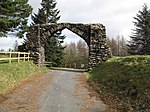 |
Notes
- ^ Sometimes known as OSGB36, the grid reference is based on the British national grid reference system used by the Ordnance Survey.
See also
 Wales portal

- Grade I listed buildings in Ceredigion
- Scheduled monuments in Ceredigion
- Registered historic parks and gardens in Ceredigion
References
- ^ "Buildings & Conservation Areas". Cadw. Retrieved 18 June 2013.
- ^ "Planning (Listed Buildings and Conservation Areas) Act 1990". The National Archives. Retrieved 18 June 2013.
- ^ Cadw. "Mabws Hall (9842)". National Historic Assets of Wales. Retrieved 8 April 2019.
- ^ "Mabws Hall". British Listed Buildings. Retrieved 8 April 2019.
- ^ Cadw. "Treforgan (9892)". National Historic Assets of Wales. Retrieved 8 April 2019.
- ^ "Treforgan". British Listed Buildings. Retrieved 8 April 2019.
- ^ Cadw. "The Old Shire Hall (10488)". National Historic Assets of Wales. Retrieved 8 April 2019.
- ^ "The Old Shire Hall". British Listed Buildings. Retrieved 8 April 2019.
- ^ "Inside one of Wales' most important Georgian country mansions that comes with outbuildings and 30 acres of land". Wales OnLine. Retrieved 20 November 2023.
- ^ Cadw. "Plas Abermad (10710)". National Historic Assets of Wales. Retrieved 8 April 2019.
- ^ "Plas Abermad". British Listed Buildings. Retrieved 8 April 2019.
- ^ Cadw. "Church of St Peter (10712)". National Historic Assets of Wales. Retrieved 8 April 2019.
- ^ "Church of St Peter". British Listed Buildings. Retrieved 8 April 2019.
- ^ Cadw. "Church of St Cynllo (10831)". National Historic Assets of Wales. Retrieved 8 April 2019.
- ^ "Church of St Cynllo". British Listed Buildings. Retrieved 8 April 2019.
- ^ Cadw. "Church of St Michael (15871)". National Historic Assets of Wales. Retrieved 8 April 2019.
- ^ "Church of St Michael". British Listed Buildings. Retrieved 8 April 2019.
- ^ Cadw. "Capel Soar and attached house (18943)". National Historic Assets of Wales. Retrieved 8 April 2019.
- ^ "Capel Soar and attached house". British Listed Buildings. Retrieved 8 April 2019.
External links
![]() Media related to Grade II* listed buildings in Ceredigion at Wikimedia Commons
Media related to Grade II* listed buildings in Ceredigion at Wikimedia Commons
- v
- t
- e
 Architecture
 Wales
Wales


