Grade I and II* listed buildings in the London Borough of Brent
Map all coordinates using OpenStreetMap
Download coordinates as:
- KML
- GPX (all coordinates)
- GPX (primary coordinates)
- GPX (secondary coordinates)
There are over 9,000 Grade I listed buildings and 20,000 Grade II* listed buildings in England. This page is a list of these buildings in the London Borough of Brent.
Grade I
| Name | Location | Type | Completed [note 1] | Date designated | Grid ref.[note 2] Geo-coordinates | Entry number [note 3] | Image |
|---|---|---|---|---|---|---|---|
| Old St Andrew's Church, Kingsbury | Brent | Church | 12th century | 6 October 1952 | TQ2063586864 51°34′05″N 0°15′42″W / 51.5680°N 0.2618°W / 51.5680; -0.2618 (Old St Andrew's Church, Kingsbury) | 1188676 | 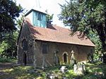 More images |
Grade II*
| Name | Location | Type | Completed [note 1] | Date designated | Grid ref.[note 2] Geo-coordinates | Entry number [note 3] | Image |
|---|---|---|---|---|---|---|---|
| Church of All Souls | Harlesden | Church | 1879 | 23 January 1974 | TQ2160883276 51°32′07″N 0°14′53″W / 51.535299°N 0.248074°W / 51.535299; -0.248074 (Church of All Souls) | 1359000 |  More images |
| Church of St Andrew | Willesden | Church | 1885 | 26 July 1951 | TQ2271584597 51°32′49″N 0°13′54″W / 51.546932°N 0.231661°W / 51.546932; -0.231661 (Church of St Andrew) | 1078881 |  More images |
| Church of St Mary | Willesden | Church | 13th century | 26 July 1951 | TQ2144684798 51°32′56″N 0°15′00″W / 51.549013°N 0.249883°W / 51.549013; -0.249883 (Church of St Mary) | 1359036 |  More images |
| Hundred Elms Farm Outbuilding | Sudbury | Outbuilding | Early 16th century | 6 October 1952 | TQ1644385882 51°33′35″N 0°19′18″W / 51.559809°N 0.321645°W / 51.559809; -0.321645 (Hundred Elms Farm Outbuilding) | 1078876 |  Upload Photo |
| Mecca Bingo | Kilburn | Cinema | 1936–37 | 10 October 1980 | TQ2504584032 51°32′29″N 0°11′54″W / 51.541343°N 0.198277°W / 51.541343; -0.198277 (Mecca Bingo) | 1078889 |  More images |
| New Parish Church of St Andrew | Kingsbury | Church | 1844–47 | 6 October 1952 | TQ2057086894 51°34′05″N 0°15′42″W / 51.568037°N 0.261793°W / 51.568037; -0.261793 (New Parish Church of St Andrew) | 1078874 |  More images |
| Sudbury Town Underground station | Sudbury | Underground station | 1930–31 | 19 February 1971 | TQ1688884888 51°33′03″N 0°18′56″W / 51.550783°N 0.315558°W / 51.550783; -0.315558 (Sudbury Town Underground station) | 1294594 |  More images |
| The Old Oxgate | Cricklewood | Farmhouse | 16th century | 26 July 1951 | TQ2247386845 51°34′02″N 0°14′04″W / 51.567187°N 0.234367°W / 51.567187; -0.234367 (The Old Oxgate) | 1078875 | Upload Photo |
Notes
- ^ a b The date given is the date used by Historic England as significant for the initial building or that of an important part in the structure's description.
- ^ a b Sometimes known as OSGB36, the grid reference is based on the British national grid reference system used by the Ordnance Survey.
- ^ a b The "List Entry Number" is a unique number assigned to each listed building and scheduled monument by Historic England.
External links
 Media related to Grade I listed buildings in the London Borough of Brent at Wikimedia Commons
- Media related to Grade II* listed buildings in the London Borough of Brent at Wikimedia Commons
- v
- t
- e
- Alperton
- Brondesbury Park
- Dollis Hill
- Harlesden
- Kensal Green
- Kilburn / Brondesbury
- Kingsbury
- Neasden (including Brent Park)
- North Wembley
- Park Royal
- Preston
- Stonebridge and Tokyngton
- Wembley and Wembley Park
- Willesden (including Church End)
| Partly in Brent |
|---|


- Brent North
- Brent Central
- Hampstead and Kilburn
 Alperton
 Brondesbury
- Brondesbury Park
- Dollis Hill
- Harlesden
- Kensal Green
- Kensal Rise
- Kenton
- Kilburn
- Kilburn Park
- Kingsbury
- Neasden
- North Wembley
- Northwick Park
- Preston Road
- Queen's Park
- Queensbury
- South Kenton
- Stonebridge Park
- Sudbury & Harrow Road
- Sudbury Town
- Wembley Central
- Wembley Park
- Wembley Stadium
- Willesden Green
- Willesden Junction

- Coat of arms
- Council
- Grade I and II* listed buildings
- Parks and open spaces
- People
- Public art
- Schools
 Category
- Commons

Portals:
 London
 Architecture


