Guanshan, Taitung
Urban township in Taiwan
You can help expand this article with text translated from the corresponding article in Chinese. (January 2022) Click [show] for important translation instructions.
- Machine translation, like DeepL or Google Translate, is a useful starting point for translations, but translators must revise errors as necessary and confirm that the translation is accurate, rather than simply copy-pasting machine-translated text into the English Wikipedia.
- Do not translate text that appears unreliable or low-quality. If possible, verify the text with references provided in the foreign-language article.
- You must provide copyright attribution in the edit summary accompanying your translation by providing an interlanguage link to the source of your translation. A model attribution edit summary is
Content in this edit is translated from the existing Chinese Wikipedia article at [[:zh:關山鎮]]; see its history for attribution. - You may also add the template
{{Translated|zh|關山鎮}}to the talk page. - For more guidance, see Wikipedia:Translation.
23°01′05″N 121°11′38″E / 23.01806°N 121.19389°E / 23.01806; 121.19389
Urban township
Guanshan Township 關山鎮 Kanzan | |
|---|---|
Urban township | |
 | |
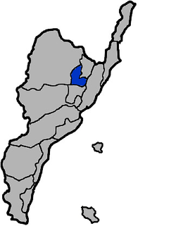 Guanshan Township in Taitung County | |
| Location | Taitung County, Taiwan |
| Area | |
| • Total | 59 km2 (23 sq mi) |
| Population (February 2023) | |
| • Total | 8,160 |
| • Density | 140/km2 (360/sq mi) |
Guanshan Township (Chinese: 關山鎮; pinyin: Guānshān Zhèn; Wade–Giles: Kuan1-shan1 Chen4) is an urban township in northern Taitung County, Taiwan.
History


Formerly called Lilong, which is from the Amis word meaning "red worms" and rendered in Hokkien as A-lí-lóng (阿里壟). By 1920, the town was called Kanzan Town under Kanzan District, Taitō Prefecture.
Geography
It is located in the Huatung Valley South segment. Beinan River flows through. In the east it is bordered by the Hai'an Range and in the west by the Central Mountain Range. Guanshan has a Tropical Monsoon Climate. Annual rainfall is 2,000 mm with an average temperature of 23.7 degrees Celsius.
Covering an area of 58.735 km2, Guanshan has a population of 8,160 people (as of February 2023).
Administrative divisions
Guanshan Township consists of 7 villages, namely Chungfu, Fengchuan, Hsinfu, Lilong, Tekao, Tienkuan and Yuemei, and 135 neighborhoods.
Economy
Rice is the most important crop in the township due to its relatively flat terrain suitable for paddy field.[1]
Tourist attractions

- Guanshan Bike Trail
- Guanshan Hongshi Trail
- Guanshan Waterfront Park[2]
- Guanshan Tianho Temple
- Nanshan Temple
- Old Guanshan Rail Station
Transportation

Guanshan Township is accessible from Guanshan Station and Haiduan Station of the Taiwan Railways.
Notable natives
- Donna Chiu, singer
- Kong Jaw-sheng, Chairperson of Financial Supervisory Commission (2004-2006)
- Lo Hsien-che, spy
- Tseng Li-cheng, taekwondo athlete
References
External links
Wikimedia Commons has media related to Guanshan Township, Taitung.
- Guanshan Township Office, Taitung County (in English)
- v
- t
- e
Cities and townships of Taitung County

- Chenggong
- Guanshan
Taiwanese Indigenous Areas | ||||||||||||||||||||||||||
|---|---|---|---|---|---|---|---|---|---|---|---|---|---|---|---|---|---|---|---|---|---|---|---|---|---|---|
| Highland indigenous Townships and Districts |
|  | ||||||||||||||||||||||||
| Plains indigenous Townships and County-Administered Cities |
| |||||||||||||||||||||||||
Note: On the map, "Mountain Indigenous Areas" are in dark green and "Plains Indigenous Areas" are in light green. | ||||||||||||||||||||||||||
| Authority control databases: Geographic |
|
|---|


