Taoyuan District, Kaohsiung
23°14′20″N 120°50′03″E / 23.238822°N 120.834289°E / 23.238822; 120.834289
Mountain Indigenous District in Kaohsiung City, Taiwan
Taoyuan 桃源區 | |
|---|---|
Mountain Indigenous District | |
| Taoyuan District[1] | |
 | |
 Taoyuan District in Kaohsiung City | |
| Country | Taiwan |
| Municipality | Kaohsiung City |
| Boroughs | List
|
| Government | |
| • Type | District government |
| • District chief | Xie Ying-xiong (KMT) |
| Area | |
| • Total | 928.98 km2 (358.68 sq mi) |
| Population (October 2023) | |
| • Total | 4,249 |
| Website | tauyuan-en |
Taoyuan District (Bunun: Ngani; Chinese: 桃源區; pinyin: Táoyuán Qū) is a mountain indigenous district of Kaohsiung City, Taiwan. It is the largest district in Kaohsiung City by area and the least densely populated district in Taiwan.
The population is mainly the indigenous Bunun people and Saaroa people.
Name
The same Pinyin form, Taoyuan District, exists in two different districts in Taiwan: one is 桃源區 in Kaohsiung, the other is 桃園區 in Taoyuan City.
Geography
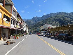
It is the district that is most mountainous and most distant from the city center. The population density in Taoyuan District is one of the least in Taiwan, but the area of the district is the sixth largest. Both Yushan National Park and Maolin National Scenic Area are situated in this district. Taoyuan District is very mountainous with very little flat land. Laonong River passes through Taoyuan District and is an important water source for Kaohsiung. The climate of the Taoyuan district is a tropical monsoon climate.
History
During the period of Japanese rule, Taoyuan was grouped with modern-day Namasia and Maolin districts and classified as "Aboriginal Areas" (蕃地), which was governed under Kizan District (旗山郡) of Takao Prefecture. After the war, the aboriginal area was renamed Yani Township (雅爾鄉, also spelled as 雅你).
On 1 July 1957, Yani Township was renamed Taoyuan Township.
In 2010, Taoyuan Township was elevated to Taoyuan District.[2]
Quick facts
- Area: 928.98 km2.
- Population: 4,249 people (October 2023)
- Divisions: 8 urban villages and 39 neighborhoods
- Postal Code: 848
- Households: 1,383 (October 2023)
Administrative divisions
| Taoyuan District administrative divisions[3] | ||||||
|---|---|---|---|---|---|---|
 Meishan Village Baoshan Village a b c d e f a: Lafuran Village b: Fushing Village c: Cinghe Village d: Taoyuan Village e: Gaojhong Village f: Jianshan Village |
Economy
Agriculture produces of the district are vegetables, fruits, processed agricultural products, prunes, jelly fig products and flowers.[4]
Tourist attractions
Notable natives
- Tseng Shu-o, famous football player
See also
References
- ^ "Administrative Districts". 高雄市政府. 30 September 2016. Retrieved 4 April 2017.
- ^ "桃源區公所-區名緣由". 桃源區公所 (in Traditional Chinese). Retrieved 2022-04-08.
- ^ "Tauyuan Township Office Web Site". 2 December 2010. Archived from the original on 16 July 2015.
- ^ "Agricultural Products". Taoyuan District Office, Kaohsiung City. Retrieved 19 April 2018.
External links
Wikimedia Commons has media related to Taoyuan District, Kaohsiung.
- Official website

- v
- t
- e
| Public universities |
|
|---|---|
| Other schools |
¹ — Mountain indigenous district
Taiwanese Indigenous Areas | ||||||||||||||||||||||||||
|---|---|---|---|---|---|---|---|---|---|---|---|---|---|---|---|---|---|---|---|---|---|---|---|---|---|---|
| Highland indigenous Townships and Districts |
| 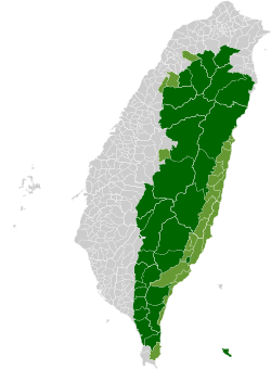 | ||||||||||||||||||||||||
| Plains indigenous Townships and County-Administered Cities |
| |||||||||||||||||||||||||
Note: On the map, "Mountain Indigenous Areas" are in dark green and "Plains Indigenous Areas" are in light green. | ||||||||||||||||||||||||||


