Chenggong, Taitung
You can help expand this article with text translated from the corresponding article in Chinese. (January 2022) Click [show] for important translation instructions.
- Machine translation, like DeepL or Google Translate, is a useful starting point for translations, but translators must revise errors as necessary and confirm that the translation is accurate, rather than simply copy-pasting machine-translated text into the English Wikipedia.
- Do not translate text that appears unreliable or low-quality. If possible, verify the text with references provided in the foreign-language article.
- You must provide copyright attribution in the edit summary accompanying your translation by providing an interlanguage link to the source of your translation. A model attribution edit summary is
Content in this edit is translated from the existing Chinese Wikipedia article at [[:zh:成功鎮]]; see its history for attribution. - You should also add the template
{{Translated|zh|成功鎮}}to the talk page. - For more guidance, see Wikipedia:Translation.
23°7′0″N 121°21′0″E / 23.11667°N 121.35000°E / 23.11667; 121.35000
Urban township
Chenggong Township 成功鎮 Shinkō, Moalaulau | |
|---|---|
Urban township | |
 | |
 Chenggong Township in Taitung County | |
| Location | Taitung County, Taiwan |
| Area | |
| • Total | 144 km2 (56 sq mi) |
| Population (February 2023) | |
| • Total | 13,193 |
| • Density | 92/km2 (240/sq mi) |
Chenggong Township or Chengkung Township (Chinese: 成功鎮; pinyin: Chénggōng Zhèn; Wade–Giles: Ch'eng2-kung1 Chen4; Pe̍h-ōe-jī: Sêng-kong-tìn) is an urban township in Taitung County, Taiwan. It is a coastal town facing the Pacific Ocean. Chenggong Fish Harbor is just west of downtown.
History
Chenggong was originally an Amis settlement from which came the Hokkien name Moalaulau (Chinese: 麻荖漏; Pe̍h-ōe-jī: Môa-láu-lāu).[1] During Japanese rule, it was renamed to Shinkō Town (Japanese: 新港街) of Taitō Prefecture. After 1945, to avoid confusion with Singang Township of Chiayi County and to distinguish it from Tainan's Sinckan (now called Sinshih), it was changed to Chenggong, which commemorates the eponymous general Koxinga (Cheng Ch'eng-kung) who expelled the Dutch from Taiwan.
Geography
The township has 13,193 inhabitants and its total area is 144.9938 km².[2]
Climate
Along with the most of the rest of Taitung County, Chenggong has a Tropical rainforest climate.
| Climate data for Chenggong (1991–2020 normals, extremes 1940–present) | |||||||||||||
|---|---|---|---|---|---|---|---|---|---|---|---|---|---|
| Month | Jan | Feb | Mar | Apr | May | Jun | Jul | Aug | Sep | Oct | Nov | Dec | Year |
| Record high °C (°F) | 28.7 (83.7) | 29.5 (85.1) | 32.5 (90.5) | 33.1 (91.6) | 35.8 (96.4) | 35.7 (96.3) | 38.1 (100.6) | 39.1 (102.4) | 37.5 (99.5) | 38.5 (101.3) | 31.5 (88.7) | 30.2 (86.4) | 39.1 (102.4) |
| Mean daily maximum °C (°F) | 22.4 (72.3) | 22.9 (73.2) | 24.3 (75.7) | 26.7 (80.1) | 29.0 (84.2) | 30.7 (87.3) | 31.8 (89.2) | 31.6 (88.9) | 30.7 (87.3) | 28.8 (83.8) | 26.4 (79.5) | 23.5 (74.3) | 27.4 (81.3) |
| Daily mean °C (°F) | 19.0 (66.2) | 19.4 (66.9) | 20.9 (69.6) | 23.2 (73.8) | 25.4 (77.7) | 27.3 (81.1) | 28.1 (82.6) | 27.9 (82.2) | 27.0 (80.6) | 25.2 (77.4) | 22.9 (73.2) | 20.2 (68.4) | 23.9 (75.0) |
| Mean daily minimum °C (°F) | 16.5 (61.7) | 16.9 (62.4) | 18.3 (64.9) | 20.6 (69.1) | 22.8 (73.0) | 24.6 (76.3) | 25.2 (77.4) | 25.0 (77.0) | 24.2 (75.6) | 22.6 (72.7) | 20.4 (68.7) | 17.8 (64.0) | 21.2 (70.2) |
| Record low °C (°F) | 6.9 (44.4) | 9.9 (49.8) | 9.8 (49.6) | 11.8 (53.2) | 16.3 (61.3) | 17.6 (63.7) | 21.3 (70.3) | 21.4 (70.5) | 17.4 (63.3) | 15.1 (59.2) | 12.0 (53.6) | 9.5 (49.1) | 6.9 (44.4) |
| Average precipitation mm (inches) | 67.3 (2.65) | 70.1 (2.76) | 70.1 (2.76) | 88.3 (3.48) | 159.8 (6.29) | 170.8 (6.72) | 245.5 (9.67) | 342.2 (13.47) | 329.3 (12.96) | 283.1 (11.15) | 153.3 (6.04) | 87.2 (3.43) | 2,067 (81.38) |
| Average precipitation days (≥ 0.1 mm) | 15.0 | 15.0 | 15.5 | 14.6 | 16.9 | 12.1 | 9.8 | 11.8 | 15.2 | 15.6 | 14.5 | 14.1 | 170.1 |
| Average relative humidity (%) | 74.7 | 76.5 | 77.7 | 79.5 | 81.5 | 82.2 | 79.7 | 79.8 | 78.5 | 74.3 | 75.2 | 73.9 | 77.8 |
| Mean monthly sunshine hours | 69.4 | 62.2 | 74.8 | 88.3 | 124.4 | 188.1 | 237.3 | 209.8 | 161 | 140.1 | 101.4 | 80.3 | 1,537.1 |
| Source: Central Weather Bureau[3][4][5][6][7] | |||||||||||||
Administrative divisions
- Bo'ai Village 博愛村
- Heping Village 和平村
- Sanmin Village 三民村
- Sanxian Village 三仙村
- Xinyi Village 信義村
- Zhongren Village 忠仁村
- Zhongxiao Village 忠孝村
- Zhongzhi Village 忠智村
Demographics
The majority inhabitants of the township are the Amis people which makes up to 53% of the population.[8]
Notable people
- Teruo Nakamura (1919-1979, Attun Palalin or Lee Guang-Hui) last known Japanese hold-out to surrender after the end of hostilities in 1945
Economy
- Agriculture
- Fisheries
- Forestry
Tourist attractions

- Amis Folk Center[9]
- Chengkung Aquarium
- Chengkuankao Cultural Landscape[10]
- Chengkuankao Matsu Temple[11]
- Chong-an Waterfall
- East Coast National Scenic Area
- Jiaping Beach
- Old Donghe Bridge
- Oceanarium
- Sanxiantai
- Shihyusan (Awana, or the Stone Umbrella)
- Siaoma Tunnel
- Singang Harbor
- Singang Waterfall
- Taitung County Museum of Natural History
- Taitung Museum of Marine Biology and Aquarium[12]
Transportation
- Provincial Highway No.11
- Chenggong Fish Harbor
- Singang Port
References
- ^ "Entry #40174 (麻荖漏)". 臺灣閩南語常用詞辭典 [Dictionary of Frequently-Used Taiwan Minnan]. (in Chinese and Hokkien). Ministry of Education, R.O.C. 2011.
- ^ "Taitung County Government English". Archived from the original on 2018-07-22. Retrieved 2014-02-28.
- ^ "Monthly Mean". Central Weather Bureau. Retrieved 29 November 2022.
- ^ "氣象站各月份最高氣溫統計" (PDF) (in Chinese). Central Weather Bureau. Retrieved 29 November 2022.
- ^ "氣象站各月份最高氣溫統計(續)" (PDF) (in Chinese). Central Weather Bureau. Retrieved 29 November 2022.
- ^ "氣象站各月份最低氣溫統計" (PDF) (in Chinese). Central Weather Bureau. Retrieved 29 November 2022.
- ^ "氣象站各月份最低氣溫統計(續)" (PDF) (in Chinese). Central Weather Bureau. Retrieved 29 November 2022.
- ^ "About Taitung". Archived from the original on 2018-07-22. Retrieved 2014-02-28.
- ^ "臺東縣觀光旅遊網". Archived from the original on 2017-07-06. Retrieved 2014-01-29.
- ^ "臺東縣觀光旅遊網". Archived from the original on 2014-02-02. Retrieved 2014-01-29.
- ^ "臺東縣觀光旅遊網". Archived from the original on 2017-07-06. Retrieved 2014-01-29.
- ^ "臺東縣觀光旅遊網". Archived from the original on 2017-07-06. Retrieved 2014-01-29.
Wikimedia Commons has media related to Chenggong Township, Taitung.
- v
- t
- e
Cities and townships of Taitung County

- Chenggong
- Guanshan
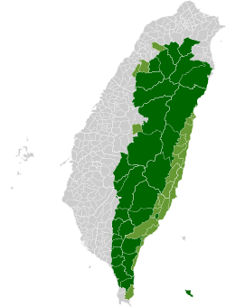
Taiwanese Indigenous Areas | ||||||||||||||||||||||||||
|---|---|---|---|---|---|---|---|---|---|---|---|---|---|---|---|---|---|---|---|---|---|---|---|---|---|---|
| Highland indigenous Townships and Districts |
|  | ||||||||||||||||||||||||
| Plains indigenous Townships and County-Administered Cities |
| |||||||||||||||||||||||||
Note: On the map, "Mountain Indigenous Areas" are in dark green and "Plains Indigenous Areas" are in light green. | ||||||||||||||||||||||||||


